Burghblizz
-
Posts
1,525 -
Joined
-
Last visited
Content Type
Profiles
Blogs
Forums
American Weather
Media Demo
Store
Gallery
Everything posted by Burghblizz
-
Sittin pretty
-

Pittsburgh, Pa Winter 2023-24 Thread.
Burghblizz replied to meatwad's topic in Upstate New York/Pennsylvania
Euro isn’t necessarily south like the NAM - it’s just a touch too warm in changing over the intial slug of moisture. It’s still close to being decent. -
Pittsburgh, Pa Winter 2023-24 Thread.
Burghblizz replied to meatwad's topic in Upstate New York/Pennsylvania
Calendar day is misleading. The 2 15”+ storms after 94 straddled calendar days. 2.5 and 2.6 of 2010 got 10+” each day I think. Also, most of us got real close to a foot 12.20 during the same day. I also got 13” in 12.03 (living in Penn Hills) during a single calendar day. Official total fell short, but eastern AGC got walloped in about 8 hours. We don’t always knock those out of the park, but they get a lot leaner as you head southwest down the Ohio river. -
Pittsburgh, Pa Winter 2023-24 Thread.
Burghblizz replied to meatwad's topic in Upstate New York/Pennsylvania
The average snow here is substantially more, but the big storm frequency is more than places to the south and west. It isn’t just the lake enhancement. Some of you guys are always looking to the ridges, the snow belt, and New England and saying woe is us. But we get substantially more synomptic snow than places to the south and places at this latitude to the west. So the criteria is appropriate even if the last 2 years have sucked. -
Pittsburgh, Pa Winter 2023-24 Thread.
Burghblizz replied to meatwad's topic in Upstate New York/Pennsylvania
GFS another a tick better. -
Pittsburgh, Pa Winter 2023-24 Thread.
Burghblizz replied to meatwad's topic in Upstate New York/Pennsylvania
Congrats Morgantown I guess… -
Pittsburgh, Pa Winter 2023-24 Thread.
Burghblizz replied to meatwad's topic in Upstate New York/Pennsylvania
With all the uncertainty, let’s go with a blend for now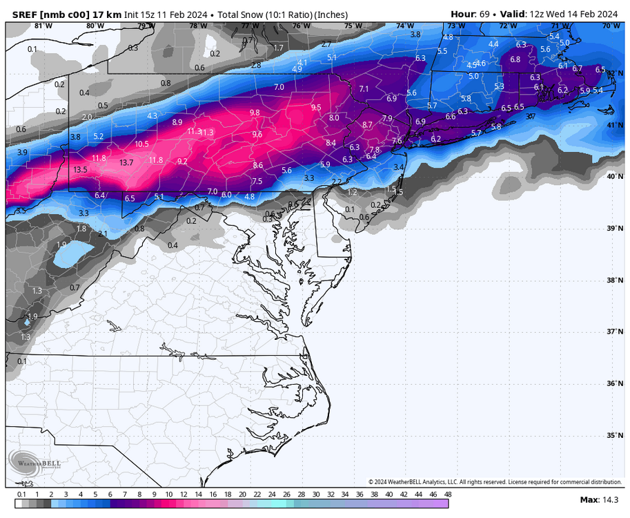
-
Pittsburgh, Pa Winter 2023-24 Thread.
Burghblizz replied to meatwad's topic in Upstate New York/Pennsylvania
I guess I’m right on their 3” line- but honestly this is easily the most nowcast event of the year. The NAM also looks like it’s going to slide a little too far SE, but the GFS will be along shortly with it’s too far NW solution. -
Pittsburgh, Pa Winter 2023-24 Thread.
Burghblizz replied to meatwad's topic in Upstate New York/Pennsylvania
I think that’s the UK with the legend off as well. I think that light blue is really 2-4 not 4-6 (and so on) -
Pittsburgh, Pa Winter 2023-24 Thread.
Burghblizz replied to meatwad's topic in Upstate New York/Pennsylvania
The NWS discussion from yesterday said something to the effect that the eventual forecast might be more of a “middle ground” as opposed to the “most likely”. I’m not sure if that spread has closed that much in the last 24 hours. I’d probably put up something like “2-5 inches, but possibly less to the south and in lower elevations where there could be more rain”. When we talk elevation in this area, forecasters love to just say ridges versus non ridges. In reality it’s more nuanced with borderline P types. I think you’ll see some differences in the metro area between 800’ and 1200’ -
Pittsburgh, Pa Winter 2023-24 Thread.
Burghblizz replied to meatwad's topic in Upstate New York/Pennsylvania
GFS looks like it might suck slightly less -
Pittsburgh, Pa Winter 2023-24 Thread.
Burghblizz replied to meatwad's topic in Upstate New York/Pennsylvania
The NWS has a HWO for Butler, Armstrong, Lawrence counties, noting that an advisory or warning might be needed in the next 36 hours. They noted too much uncertainty for right now. Thats fair and is a better strategy than CTPs “WSW kind of” strategy.I bet they are waiting for the rest of 12Z to make a call for watches for the northern metro area. I think they wait on AGC regardless, and add it if things trend well by tonight. Just too many red flags still. -
Pittsburgh, Pa Winter 2023-24 Thread.
Burghblizz replied to meatwad's topic in Upstate New York/Pennsylvania
Looks like a more realistic depiction of the NAM. Totals moderated a bit, and scaled way back in the Mon valley. -
Pittsburgh, Pa Winter 2023-24 Thread.
Burghblizz replied to meatwad's topic in Upstate New York/Pennsylvania
The other interesting thing is that it also has a different orientation of the precip shield. Has precip into NW PA, where 12k is dry. In upstate NY, you have some areas that have 12+, but zero in the 12k. Not sure that is too common. I would expect the differences to be more in micro details. Not sure I understand why that would be the case, but the models can’t even agree with themselves. -
Pittsburgh, Pa Winter 2023-24 Thread.
Burghblizz replied to meatwad's topic in Upstate New York/Pennsylvania
The thermals really create the boom or bust scenario. Probably more of a tapered look to totals if we were just worried about precip. I do feel a little better about middle of the night/early morning in February versus if it were middle of the day in March. -
Pittsburgh, Pa Winter 2023-24 Thread.
Burghblizz replied to meatwad's topic in Upstate New York/Pennsylvania
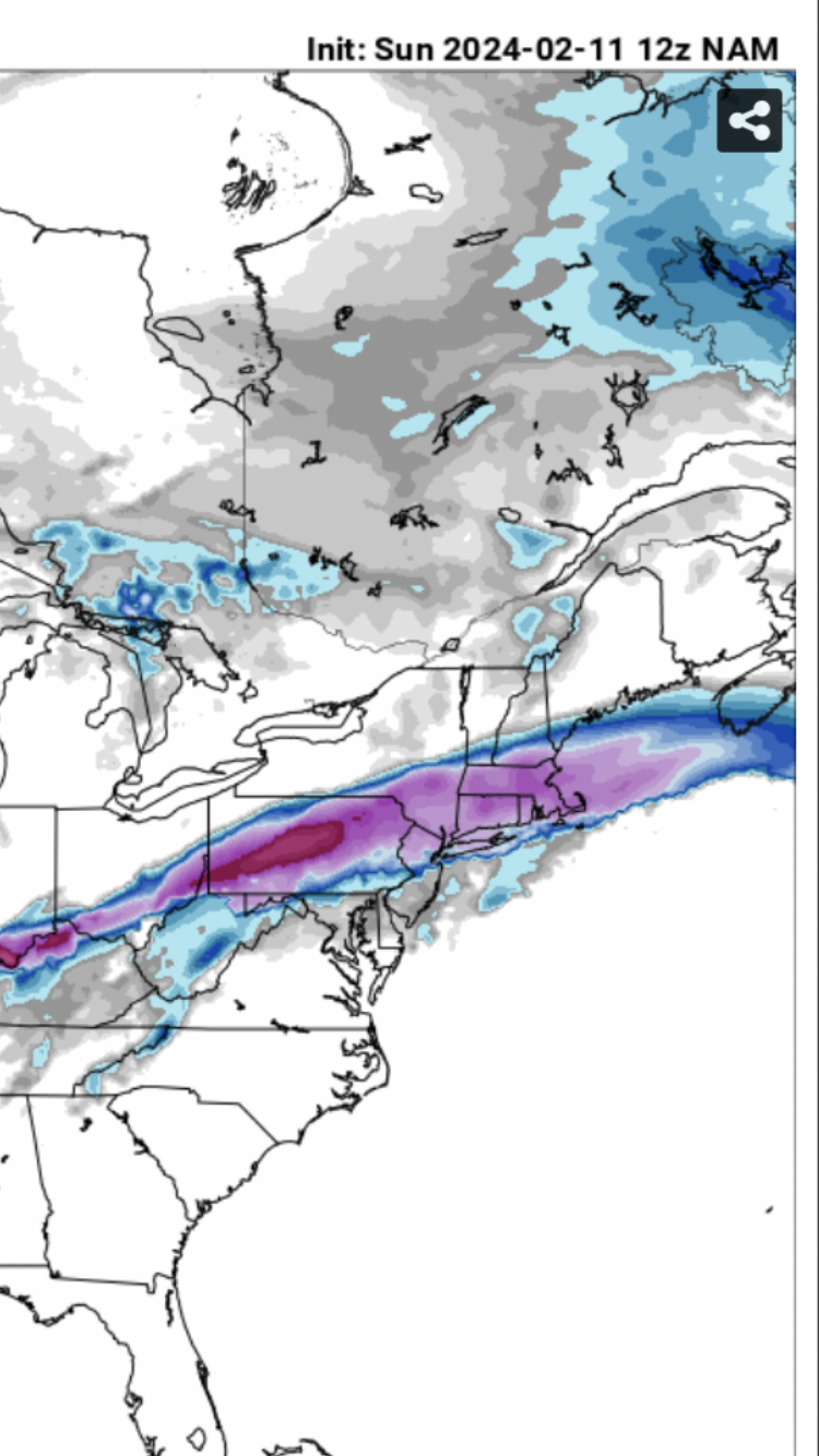
12Z NAM 10:1 strip of 12+ just for fun. I think we would gladly take the old “cut in half rule” here: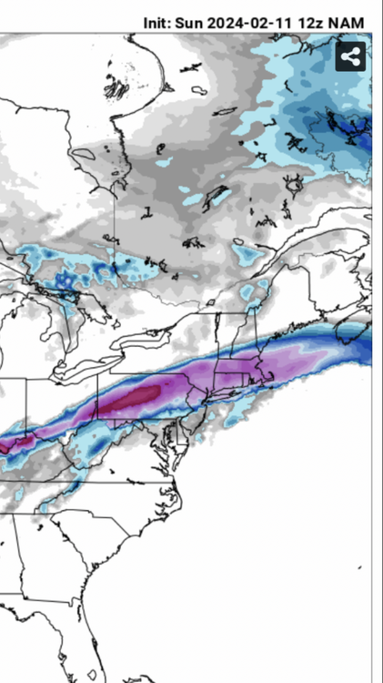
-
Pittsburgh, Pa Winter 2023-24 Thread.
Burghblizz replied to meatwad's topic in Upstate New York/Pennsylvania
NAM not giving up - in fact its better for SW PA -
Pittsburgh, Pa Winter 2023-24 Thread.
Burghblizz replied to meatwad's topic in Upstate New York/Pennsylvania
It’s certainly shifted south away from us enough times -
Pittsburgh, Pa Winter 2023-24 Thread.
Burghblizz replied to meatwad's topic in Upstate New York/Pennsylvania
Kuchera actually a little more robust. Brutal cutoff though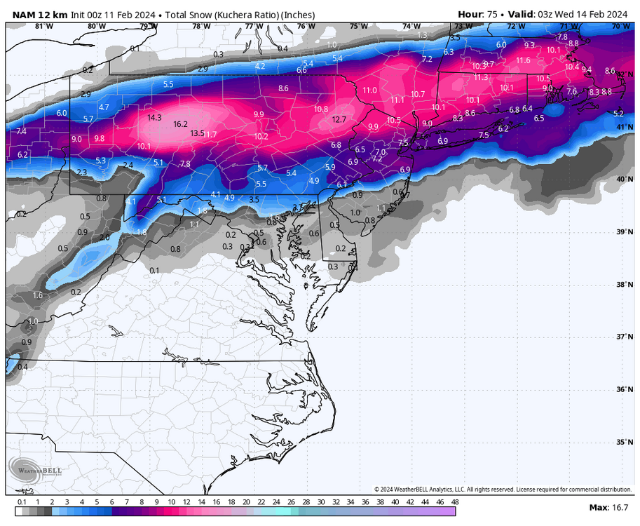
-
Pittsburgh, Pa Winter 2023-24 Thread.
Burghblizz replied to meatwad's topic in Upstate New York/Pennsylvania
NAM isn’t great for central and southern AGC - but not a complete disaster. Still looking decent northern AGC and Butler. Southern Border counties look in trouble. The one improvement was more moisture to the west, so anyone on the good side of the changeover has a little more time to work. (I know - could just mean staying sucked in longer) -
Pittsburgh, Pa Winter 2023-24 Thread.
Burghblizz replied to meatwad's topic in Upstate New York/Pennsylvania
Wanna see if the NAM holds on before completely throwing it in. -
Pittsburgh, Pa Winter 2023-24 Thread.
Burghblizz replied to meatwad's topic in Upstate New York/Pennsylvania
Good write up. The only thing that feels different to me is how far south the NAM and Ukie are (with Canadian being a non storm). Gives me at least some hope that the final solution ticks back south instead of the other way. -
Pittsburgh, Pa Winter 2023-24 Thread.
Burghblizz replied to meatwad's topic in Upstate New York/Pennsylvania
Euro looking like the GFS did yesterday. 8” IMBY….but AGC is the battleground with a rapid drop off. -
Pittsburgh, Pa Winter 2023-24 Thread.
Burghblizz replied to meatwad's topic in Upstate New York/Pennsylvania
Was just looking at that. Could be another sign that the it’s GFS Op versus the world. -
Pittsburgh, Pa Winter 2023-24 Thread.
Burghblizz replied to meatwad's topic in Upstate New York/Pennsylvania
That was the Canadian being contrasted to the GFS. GFS is just too amped up.