

Burghblizz
-
Posts
1,525 -
Joined
-
Last visited
Content Type
Profiles
Blogs
Forums
American Weather
Media Demo
Store
Gallery
Everything posted by Burghblizz
-

Pittsburgh, Pa Winter 2023-24 Thread.
Burghblizz replied to meatwad's topic in Upstate New York/Pennsylvania
Wouldn’t be shocked to see an inch or two along the I70 corridor this morning. Healthy little batch of steady snow. That was modeled way south a few days ago -
Pittsburgh, Pa Winter 2023-24 Thread.
Burghblizz replied to meatwad's topic in Upstate New York/Pennsylvania
He still has this as his “pinned tweet”. Kind of silly at this point. Have to hope for a strong March. -
Pittsburgh, Pa Winter 2023-24 Thread.
Burghblizz replied to meatwad's topic in Upstate New York/Pennsylvania
Rippin here right now. Heaviest I’ve personally seen since yesterday. Great morning (although, not gonna lie, jealous of 6-7” 20 miles away) -
Pittsburgh, Pa Winter 2023-24 Thread.
Burghblizz replied to meatwad's topic in Upstate New York/Pennsylvania
Seeing also 6+ in Plum too. Which basically means that band…cutting through the center of the entire length of Allegheny County will wind up dropping 6-8”. Even though that cuts through a pretty populated swath, not sure we have a ton of posters that got to enjoy it full on. But still a pretty remarkable event. -
Pittsburgh, Pa Winter 2023-24 Thread.
Burghblizz replied to meatwad's topic in Upstate New York/Pennsylvania
It was kind of fringed, and the NWS is on Shafer road with is even a touch north from there. -
Pittsburgh, Pa Winter 2023-24 Thread.
Burghblizz replied to meatwad's topic in Upstate New York/Pennsylvania
Imperial - literally 5 miles from the airport. 6.5”. If I recall, they got the lake band too. People there are probably thinking it ain’t a bad winter -
It’s a pretty narrow band, it just happens to be going right through the city. Places west of the city into eastern Ohio have 6-10”. Outside of the mega band, I think we are looking at more like a widespread 2-4”.
-
Pittsburgh, Pa Winter 2023-24 Thread.
Burghblizz replied to meatwad's topic in Upstate New York/Pennsylvania
The mesos did have some weenie bands, but not in that area. Was further south and east. -
Pittsburgh, Pa Winter 2023-24 Thread.
Burghblizz replied to meatwad's topic in Upstate New York/Pennsylvania
Correction - 7” already in Steubenville -
Pittsburgh, Pa Winter 2023-24 Thread.
Burghblizz replied to meatwad's topic in Upstate New York/Pennsylvania
Airport looks like it’s been catching the northern fringe of the band. 1.5” in the last two hours, with 2” total. Steubenville/Wintersville area is about 25 miles southwest and is pushing 6”. Some of those types of totals will likely translate east. Definitely a nowcast storm. Certainly looked like the sweet spot would be further south. -
Pittsburgh, Pa Winter 2023-24 Thread.
Burghblizz replied to meatwad's topic in Upstate New York/Pennsylvania
Totals in eastern Ohio are going to be interesting. Places near Steubenville with 4” and a good bit to go. I saw about 2” downtown already but not a lot of reports from the western suburbs yet. Figure some folks there are doing well. -
Pittsburgh, Pa Winter 2023-24 Thread.
Burghblizz replied to meatwad's topic in Upstate New York/Pennsylvania
Band in Ohio getting thicker. Hoping that can swing north a little. I got into a little heavier snow, but mostly on the outside looking in still. About a half inch so far -
Pittsburgh, Pa Winter 2023-24 Thread.
Burghblizz replied to meatwad's topic in Upstate New York/Pennsylvania
Downtown getting drilled -
Pittsburgh, Pa Winter 2023-24 Thread.
Burghblizz replied to meatwad's topic in Upstate New York/Pennsylvania
Big fan of rates and daytime. Daytime is definitely out, but at least it looks like it won’t be in the middle of the night. I think south of the city still looks really good. I’m a little worried we northern people might not quite get the heavy stuff, but we’ll see. The 2:00 advisory update now advertising “3-5 with locally higher along route 70” -
Pittsburgh, Pa Winter 2023-24 Thread.
Burghblizz replied to meatwad's topic in Upstate New York/Pennsylvania
Models (and now radar) have shown this northern tongue of sorts that looks to get the precip going sooner. Will be interesting to see where this sets up, as it could help with some of the totals along the northern side of this. -
Pittsburgh, Pa Winter 2023-24 Thread.
Burghblizz replied to meatwad's topic in Upstate New York/Pennsylvania
Weenie band getting thicker. I still think the best energy is probably south of this depiction locally, but will be an interesting nowcast this evening. Westmoreland pounded on the run.p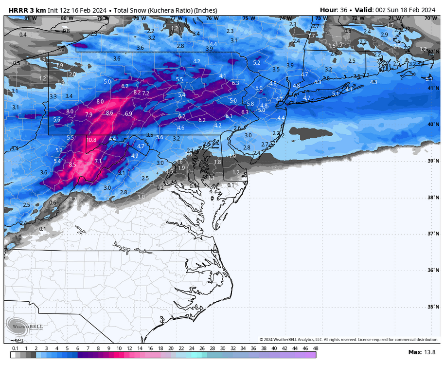
-
Pittsburgh, Pa Winter 2023-24 Thread.
Burghblizz replied to meatwad's topic in Upstate New York/Pennsylvania
HRRR Weenie band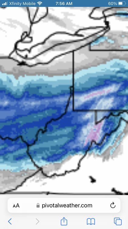
-
Pittsburgh, Pa Winter 2023-24 Thread.
Burghblizz replied to meatwad's topic in Upstate New York/Pennsylvania
I’m probably a touch north for this, but thinking there are some sweet spots (4”+) in the south hills or Westmoreland county. Basically far enough north to catch some better ratios, but far enough south to catch higher precip amounts. -
Pittsburgh, Pa Winter 2023-24 Thread.
Burghblizz replied to meatwad's topic in Upstate New York/Pennsylvania
03Z RAP depiction is in the north camp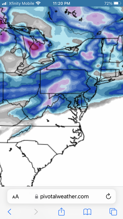
-
Pittsburgh, Pa Winter 2023-24 Thread.
Burghblizz replied to meatwad's topic in Upstate New York/Pennsylvania
Probably out to lunch with the totals, but that banding is interesting. Maybe some localized jackpot areas. -
Pittsburgh, Pa Winter 2023-24 Thread.
Burghblizz replied to meatwad's topic in Upstate New York/Pennsylvania
South of town looking good. -
Pittsburgh, Pa Winter 2023-24 Thread.
Burghblizz replied to meatwad's topic in Upstate New York/Pennsylvania
Great call outs. It’s easy to look at the surface and where the precip is depicted, but it’s the upper levels that drives it. -
Pittsburgh, Pa Winter 2023-24 Thread.
Burghblizz replied to meatwad's topic in Upstate New York/Pennsylvania
I’ve lived that scenario(figuratively), and this isn’t quite that. Dec 2000 and March 2001 in Harrisburg, I lost 3’ of predicted snow at nowcast time. Some of our WTODs had that vibe too This one always had red flags. I spent a lot of time on it because the modeling was so interesting and would have been a fun threading of the needle. -
Pittsburgh, Pa Winter 2023-24 Thread.
Burghblizz replied to meatwad's topic in Upstate New York/Pennsylvania
The funny thing is we got a rare SE shift, just the precip seemed to vanish on the NW side. Crazy -
You mean 2000? I was in Harrisburg at the time. Sunny skies.


