

Burghblizz
-
Posts
1,525 -
Joined
-
Last visited
Content Type
Profiles
Blogs
Forums
American Weather
Media Demo
Store
Gallery
Everything posted by Burghblizz
-

Pittsburgh/Western PA Winter 2024-2025 Thread
Burghblizz replied to Rd9108's topic in Upstate New York/Pennsylvania
Wouldn’t be shocked to see the same today, although the first batch got obliterated. -
Pittsburgh/Western PA Winter 2024-2025 Thread
Burghblizz replied to Rd9108's topic in Upstate New York/Pennsylvania
Looks like a general 2-3”. Not bad. Getting sleety/slushy here now. GFS was advertising a pretty thin but robust strip on the back end tomorrow, extending NE from southern Ohio. We’ll see if that sets up like that. https://www.pivotalweather.com/model.php?p=snku_acc-imp&rh=2025021512&fh=48 -
Pittsburgh/Western PA Winter 2024-2025 Thread
Burghblizz replied to Rd9108's topic in Upstate New York/Pennsylvania
Never loved knowing snow is going to get washed away - but real nice morning here. Mod snow and 1.5” on the ground so far. -
Pittsburgh/Western PA Winter 2024-2025 Thread
Burghblizz replied to Rd9108's topic in Upstate New York/Pennsylvania
Trend this year has been the lack of the usual north trend. Maybe that plays in our favor. -
Pittsburgh/Western PA Winter 2024-2025 Thread
Burghblizz replied to Rd9108's topic in Upstate New York/Pennsylvania
Had a bunch of thunder and (technically) mostly freezing rain. Tree limbs probably had .1”-.15”, but roads were mostly fine here. I feel like New Castle and Butler stayed snow for awhile but I didn’t look up reports. -
Pittsburgh/Western PA Winter 2024-2025 Thread
Burghblizz replied to Rd9108's topic in Upstate New York/Pennsylvania
I got woken up by thunder last night. Probably would have been an interesting spectacle if during the day, with freezing rain falling. Just slid above freezing, but looks like a pretty good coating of ice on cars outside here. -
Pittsburgh/Western PA Winter 2024-2025 Thread
Burghblizz replied to Rd9108's topic in Upstate New York/Pennsylvania
I have a really anti climatic Winter Storm Watch. Mostly for ice, and probably northern Butler county. I’ll take some front end snow and skip the ice. -
Pittsburgh/Western PA Winter 2024-2025 Thread
Burghblizz replied to Rd9108's topic in Upstate New York/Pennsylvania
It’s wild that it snowed at some point on Wed. Thought for sure that ended the streak. -
Pittsburgh/Western PA Winter 2024-2025 Thread
Burghblizz replied to Rd9108's topic in Upstate New York/Pennsylvania
I saw some PWS’s around me in the -14 to -17 range. Zeli is also about 7 or 8 miles away. Impressive cold! Today is looking like the first day of the month with zero snow. Would love to land a widespread big storm. A couple moderate ones so far, but they have been dissecting the area. -
Pittsburgh/Western PA Winter 2024-2025 Thread
Burghblizz replied to Rd9108's topic in Upstate New York/Pennsylvania
I think some of the rural areas get to -15. -
Pittsburgh/Western PA Winter 2024-2025 Thread
Burghblizz replied to Rd9108's topic in Upstate New York/Pennsylvania
-6 IMBY Seeing as low as -11 close by on WeatherBug. Curious to see what some of these rural places show tomorrow morning. -
Pittsburgh/Western PA Winter 2024-2025 Thread
Burghblizz replied to Rd9108's topic in Upstate New York/Pennsylvania
Got 3.5” total last night. Didn’t happen exactly the way I thought, but definitely did the job of freshening up the snowpack. -
Pittsburgh/Western PA Winter 2024-2025 Thread
Burghblizz replied to Rd9108's topic in Upstate New York/Pennsylvania
Another nice band dropping into SW Butler county and entering northern AGC. i got a coating of pixie dust off the initial system, but probably will be close to 3” total off these LES bands. -
Pittsburgh/Western PA Winter 2024-2025 Thread
Burghblizz replied to Rd9108's topic in Upstate New York/Pennsylvania
POUNDING here. 2” last hour -
Pittsburgh/Western PA Winter 2024-2025 Thread
Burghblizz replied to Rd9108's topic in Upstate New York/Pennsylvania
Mailman and Chalk Hill look to be getting the good stuff -
Pittsburgh/Western PA Winter 2024-2025 Thread
Burghblizz replied to Rd9108's topic in Upstate New York/Pennsylvania
This “higher end” product is something.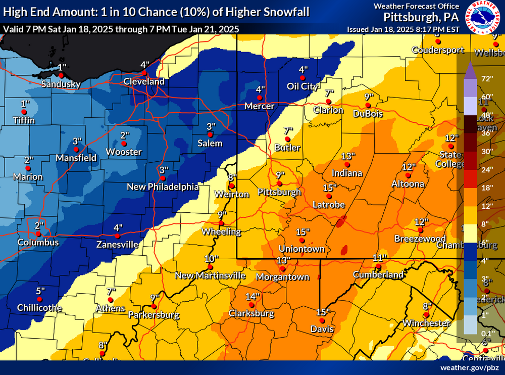
-
Pittsburgh/Western PA Winter 2024-2025 Thread
Burghblizz replied to Rd9108's topic in Upstate New York/Pennsylvania
NAM giving Mon Valley a chance. -
Pittsburgh/Western PA Winter 2024-2025 Thread
Burghblizz replied to Rd9108's topic in Upstate New York/Pennsylvania
So basically Canada against the world Sunday. Haven’t put a lot into that, so that would be a huge bonus if it verifies -
Pittsburgh/Western PA Winter 2024-2025 Thread
Burghblizz replied to Rd9108's topic in Upstate New York/Pennsylvania
Yeah - I saw some yellow popping on radar (then watched it slide south of me) -
Pittsburgh/Western PA Winter 2024-2025 Thread
Burghblizz replied to Rd9108's topic in Upstate New York/Pennsylvania
Is your house on one of the runways at the airport? There has been a lot of localized banding during this period, and one decent storm that had a sharp cutoff. I’m probably around 18-20” for the season here. -
Pittsburgh/Western PA Winter 2024-2025 Thread
Burghblizz replied to Rd9108's topic in Upstate New York/Pennsylvania
It going to pivot to be more snow showers and less uniform. Looks like the first decent band incoming. -
Pittsburgh/Western PA Winter 2024-2025 Thread
Burghblizz replied to Rd9108's topic in Upstate New York/Pennsylvania
Meanwhile - it’s thumping now -
Pittsburgh/Western PA Winter 2024-2025 Thread
Burghblizz replied to Rd9108's topic in Upstate New York/Pennsylvania
Good NWS discussion today. Basically saying that even though there may not be a widespread 3” average to meet advisory criteria, the cold temps along with Tuesdays road issues helped build the case. It should be flexible based on impact. I think we see a high floor with totals today(2+). Good ratios, and interested to see if there is banding later. -
Pittsburgh/Western PA Winter 2024-2025 Thread
Burghblizz replied to Rd9108's topic in Upstate New York/Pennsylvania
Nothing major, but daytime snow on snow is nice. -
Pittsburgh/Western PA Winter 2024-2025 Thread
Burghblizz replied to Rd9108's topic in Upstate New York/Pennsylvania
It has snowed every day in January so far.

