

Burghblizz
-
Posts
1,525 -
Joined
-
Last visited
Content Type
Profiles
Blogs
Forums
American Weather
Media Demo
Store
Gallery
Everything posted by Burghblizz
-

Western PA/Pittsburgh Winter 2021/22 Discussion
Burghblizz replied to meatwad's topic in Upstate New York/Pennsylvania
Dumping - back to all snow in Cranberry. 2.5” and .5” fresh during the 20 min I was just walking the dog -
Central PA - Winter 2021/2022
Burghblizz replied to Bubbler86's topic in Upstate New York/Pennsylvania
It’s ripping here, despite what K-weenie sells. Been occasionally mixing, but heavy snow at the moment and still early on. -
Western PA/Pittsburgh Winter 2021/22 Discussion
Burghblizz replied to meatwad's topic in Upstate New York/Pennsylvania
As far as actual weather and not the weenie fest… When you have a strong 925 jet advecting into cold air, you have the recipe for some intense rates. But might have to flirt with some sleet to get it. -
Western PA/Pittsburgh Winter 2021/22 Discussion
Burghblizz replied to meatwad's topic in Upstate New York/Pennsylvania
Heavy snow in Cranberry. 24 degrees. Wind driven smaller flakes have turned to big fatties -
Western PA/Pittsburgh Winter 2021/22 Discussion
Burghblizz replied to meatwad's topic in Upstate New York/Pennsylvania
More wind driven and powdery than I was expecting to begin with -
Western PA/Pittsburgh Winter 2021/22 Discussion
Burghblizz replied to meatwad's topic in Upstate New York/Pennsylvania
One cat basically so weenied out that it makes it MA thread vibe. But they have like 20 like that -
Western PA/Pittsburgh Winter 2021/22 Discussion
Burghblizz replied to meatwad's topic in Upstate New York/Pennsylvania
-
Western PA/Pittsburgh Winter 2021/22 Discussion
Burghblizz replied to meatwad's topic in Upstate New York/Pennsylvania
Keep those southern obs coming -
Western PA/Pittsburgh Winter 2021/22 Discussion
Burghblizz replied to meatwad's topic in Upstate New York/Pennsylvania
If we can avoid the snow cone, the blowing and drifting might be understated to this point -
Western PA/Pittsburgh Winter 2021/22 Discussion
Burghblizz replied to meatwad's topic in Upstate New York/Pennsylvania
That’s my plan too. Sleep during dry slot :-) -
Western PA/Pittsburgh Winter 2021/22 Discussion
Burghblizz replied to meatwad's topic in Upstate New York/Pennsylvania
That’s the plan! (but I plan on a fun night regardless) -
Western PA/Pittsburgh Winter 2021/22 Discussion
Burghblizz replied to meatwad's topic in Upstate New York/Pennsylvania
Yinz are going to drive yourselves nuts clicking on hourly increments of hourly models for the 8 hours, and checking where the pretty colors line up. I think E to W across central AGC will be the difference between 8 and 12 because of dry slot duration. And N to S along that axis will add or subtract ~2” from that range. Beaver /Lawrence/Butler certainly have a shot to pop a 15” total. -
Western PA/Pittsburgh Winter 2021/22 Discussion
Burghblizz replied to meatwad's topic in Upstate New York/Pennsylvania
And just for fun the “best case” experimental view. That dry slot on NAM is still pretty fierce where I could see a place like Wheeling doubling up Greensburg. But in general, the NAM seems to have lost the total shit show solution, which is one of things I wanted to see.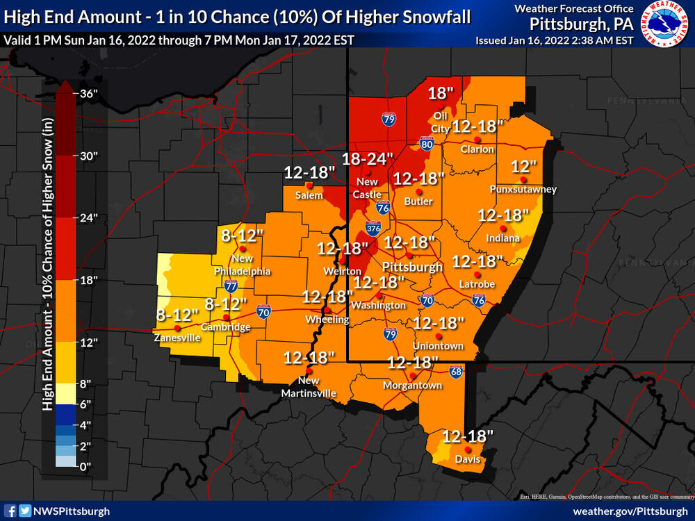
-
Central PA - Winter 2021/2022
Burghblizz replied to Bubbler86's topic in Upstate New York/Pennsylvania
Not sure how Tolleris is resolving the fact that the NW edge outside his sleet line is where the totals should ramp up - yet that’s where he has the totals drop off. Probably the single most important issue in terms of where big totals wind up. He tries to forecast for a wide area, and doesn’t put diligence into those areas. -
Western PA/Pittsburgh Winter 2021/22 Discussion
Burghblizz replied to meatwad's topic in Upstate New York/Pennsylvania
I’ll start to worry about the NAM at 0z. At that point, all the anecoctal, weather fan reasons to toss it become fewer. It will be an on hour run with the storm arriving within 24 hours. That’s usually where it’s considered good. -
Western PA/Pittsburgh Winter 2021/22 Discussion
Burghblizz replied to meatwad's topic in Upstate New York/Pennsylvania
Way different with low track. And mixing here means potential sig ice, not rain like in 1.19 -
Western PA/Pittsburgh Winter 2021/22 Discussion
Burghblizz replied to meatwad's topic in Upstate New York/Pennsylvania
If we can avoid the frozen snow cone…and I think most will to a large degree…they really might want to consider adding “bowing and drifting” to the forecast Monday. Could be 30 MPH winds with snow showers and a lot of snow on the ground. -
Western PA/Pittsburgh Winter 2021/22 Discussion
Burghblizz replied to meatwad's topic in Upstate New York/Pennsylvania
I wouldn’t worry about the exact orientation of pink and blue. I think that’s a 2” hour. -
Western PA/Pittsburgh Winter 2021/22 Discussion
Burghblizz replied to meatwad's topic in Upstate New York/Pennsylvania
I think this is why we all do well - but it’s like 5” to 12” well, as opposed to a nice tight range. Where it’s ripping it will be ripping. Where it’s not, it might be a light mix for while, which will further hold totals down. So any prolonged period with that gets you behind the game. So a deeper storm hurts - because of the warm air aloft. But it also can HELP with dynamic cooling. -
Western PA/Pittsburgh Winter 2021/22 Discussion
Burghblizz replied to meatwad's topic in Upstate New York/Pennsylvania
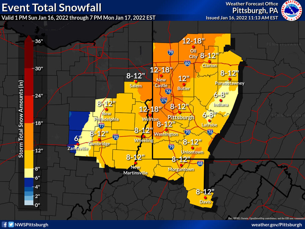
When the bad outlier for PIT is 7”, I’ll take it. It does really show the worst case scenario though for Fayette and Westmoreland (talking NAM) -
Western PA/Pittsburgh Winter 2021/22 Discussion
Burghblizz replied to meatwad's topic in Upstate New York/Pennsylvania
It’s good if you want to see if a you have some good rates in the next few hours - but I wouldn’t look at totals 30 hours before the storm. -
Western PA/Pittsburgh Winter 2021/22 Discussion
Burghblizz replied to meatwad's topic in Upstate New York/Pennsylvania
GFS looking nice and robust still at 18Z -
Central PA - Winter 2021/2022
Burghblizz replied to Bubbler86's topic in Upstate New York/Pennsylvania
Thanks for your thoughts. He was weenying out a bit -
Western PA/Pittsburgh Winter 2021/22 Discussion
Burghblizz replied to meatwad's topic in Upstate New York/Pennsylvania
If you are looking for a trend, it’s snowier than 12Z. Fills in a wider swath of 6”+ and gets that 12+ tail closer from the NW. Sure, Its the worst model for us still, but it’s better than it was. -
Western PA/Pittsburgh Winter 2021/22 Discussion
Burghblizz replied to meatwad's topic in Upstate New York/Pennsylvania
GFS looks fine. 12-15” city and points North and West. More mixing south and east, but still warning snows there too before any crap. That 119 corridor looks most susceptible. Seems to extend the backend a little too. A post storm snow globe day Monday would hit the spot.


