

Burghblizz
-
Posts
1,525 -
Joined
-
Last visited
Content Type
Profiles
Blogs
Forums
American Weather
Media Demo
Store
Gallery
Everything posted by Burghblizz
-

Western PA/Pittsburgh Winter 2021/22 Discussion
Burghblizz replied to meatwad's topic in Upstate New York/Pennsylvania
Some nice bands blowing up again in AGC. Almost like LES but coming from the SW. -
Western PA/Pittsburgh Winter 2021/22 Discussion
Burghblizz replied to meatwad's topic in Upstate New York/Pennsylvania
Yesterday was like watching paint dry. Wound up with ~.30 ice accretion with the snow line agonizingly close for hours in the evening. I’m catching some of that Northern Allegheny band now. Nice fat flakes. -
Western PA/Pittsburgh Winter 2021/22 Discussion
Burghblizz replied to meatwad's topic in Upstate New York/Pennsylvania
I have to think they have had some since then (seems as though they have cashed in on a lot of our snow over the years) But fair thought - our storms since that got close or over that (‘94, ‘96, ‘03, ‘10) were considerably lighter there. -
Hoping to see reports of cold racing east
-
Western PA/Pittsburgh Winter 2021/22 Discussion
Burghblizz replied to meatwad's topic in Upstate New York/Pennsylvania
Euro looks good NW of the city. Gives me about 8” (also about 20 miles from 4” and 20 miles from a foot ) -
Western PA/Pittsburgh Winter 2021/22 Discussion
Burghblizz replied to meatwad's topic in Upstate New York/Pennsylvania
They should manually smooth that out. Doubt it plays out that way -
Western PA/Pittsburgh Winter 2021/22 Discussion
Burghblizz replied to meatwad's topic in Upstate New York/Pennsylvania
There definitely is a good chunk of the area that has a combination of trees and above ground lines - not a great combo. But severe ice storms aren’t too frequent thankfully. -
Western PA/Pittsburgh Winter 2021/22 Discussion
Burghblizz replied to meatwad's topic in Upstate New York/Pennsylvania
NAM slightly colder and also develops another wave. Taken literally, the city is in icy hell in between, but dropped the bigger totals a little closer from the north, and then developed another band of 3-4” snows south -
Western PA/Pittsburgh Winter 2021/22 Discussion
Burghblizz replied to meatwad's topic in Upstate New York/Pennsylvania
I think there will be last minute shifts that will drive us nut - But this is the accurate story to me as well. Since I’m a bit NW of that line, hoping for more snow. Certainly support for 6”+ N of the city - just TBD if that starts at 5 miles or 50 miles. We’d be in better shape if we get a little more eastern progression before the main wave comes and tries to advect warm air. -
Western PA/Pittsburgh Winter 2021/22 Discussion
Burghblizz replied to meatwad's topic in Upstate New York/Pennsylvania
I wouldn’t feel great in the WV border counties, but rest of the area still has a shot. Obviously even better North and West of the city. -
Western PA/Pittsburgh Winter 2021/22 Discussion
Burghblizz replied to meatwad's topic in Upstate New York/Pennsylvania
Those areas aren’t staying in the waves of precip as long due to the slightly more progressive nature. So it was more timing as opposed to system strength. GFS has a chance to be the king here. I feel like others are trending to it more than it’s trending to others. But you still have to be concerned about a tick the wrong way. -
Western PA/Pittsburgh Winter 2021/22 Discussion
Burghblizz replied to meatwad's topic in Upstate New York/Pennsylvania
I weenied out a bit and looked at the soundings for my backyard (Cranberry). It was right on pivotals sleet line, but the soundings never went above freezing at any level. I’d love to see another model join the GFS though. Getting real close to something nice for northern AGC and points N. -
Western PA/Pittsburgh Winter 2021/22 Discussion
Burghblizz replied to meatwad's topic in Upstate New York/Pennsylvania
Maybe - but I would think they would manually adjust that for a public forecast -
Western PA/Pittsburgh Winter 2021/22 Discussion
Burghblizz replied to meatwad's topic in Upstate New York/Pennsylvania
Damn…and his foot line is IMBY. I wouldnt look too much into it even if he is a good met. Our locals lose attention to detail quickly when it’s out of the viewing area. -
Western PA/Pittsburgh Winter 2021/22 Discussion
Burghblizz replied to meatwad's topic in Upstate New York/Pennsylvania
They were taking victory laps left and right in the MLK storm, even though the total fell within every outlets range. If they want to score a win though, this might be the storm to do it. Somewhere from PGH to the NW figures to really cash in. But it would be a bold call at this point to slide 6”+ type totals into the city. -
Western PA/Pittsburgh Winter 2021/22 Discussion
Burghblizz replied to meatwad's topic in Upstate New York/Pennsylvania
Might not translate to snow output, but the high presses east a little quicker in NAM. Good trend. Verbatim still probably a helluva sleet storm. -
Western PA/Pittsburgh Winter 2021/22 Discussion
Burghblizz replied to meatwad's topic in Upstate New York/Pennsylvania
GEFS lookin better.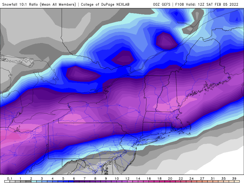
-
Western PA/Pittsburgh Winter 2021/22 Discussion
Burghblizz replied to meatwad's topic in Upstate New York/Pennsylvania
That counts a lot of sleet as 10:1 snow, especially in Kentucky and Southern Ohio. But if we can get that warm layer out.. -
Western PA/Pittsburgh Winter 2021/22 Discussion
Burghblizz replied to meatwad's topic in Upstate New York/Pennsylvania
That boundary is tight. GFS was actually a little colder than 12Z, but didn’t extend the wave of precip as far into Friday. But it largely held serve. The NAM wasn’t anything great for us, but does get a raging sleet storm pretty close. Still think this feels like big hit for NW PA/NE OH. My glimmer of hope is that I have seen the rushing of cold air undermodeled here, similar to the way warm air advecting often is. -
Western PA/Pittsburgh Winter 2021/22 Discussion
Burghblizz replied to meatwad's topic in Upstate New York/Pennsylvania
Not sure what it is about that storm that you have turned a 6” to 10” storm (with general 6-12” type forecasts into a “bust”. Stop looking at the prettiest color on the best model. -
Western PA/Pittsburgh Winter 2021/22 Discussion
Burghblizz replied to meatwad's topic in Upstate New York/Pennsylvania
Euro isn’t great, but those more robust snows are inching SE -
Western PA/Pittsburgh Winter 2021/22 Discussion
Burghblizz replied to meatwad's topic in Upstate New York/Pennsylvania
GFS ensembles are a lot more NW. Overall trend is good, but we really need that high to push down. That’s what I’ll be watching as far as trends in strength and position. I expect the Euro to have its shit all over Lake Erie. But if it’s also south, I’ll really start to believe. -
Western PA/Pittsburgh Winter 2021/22 Discussion
Burghblizz replied to meatwad's topic in Upstate New York/Pennsylvania
I’m some circles…but there is a great complaint thread for that Another 8-12” would great, especially considering the best contour in the best model isn’t our “forecast” This still “feels” a little NW to me for that, but still time. Gotta get that cold air on the march -
Western PA/Pittsburgh Winter 2021/22 Discussion
Burghblizz replied to meatwad's topic in Upstate New York/Pennsylvania
No doubt -
Western PA/Pittsburgh Winter 2021/22 Discussion
Burghblizz replied to meatwad's topic in Upstate New York/Pennsylvania
This look will be likelly be a overstated versus Kuchera because I think it pretends frozen is snow.
