Burghblizz
-
Posts
1,525 -
Joined
-
Last visited
Content Type
Profiles
Blogs
Forums
American Weather
Media Demo
Store
Gallery
Everything posted by Burghblizz
-
I think you have to look at departure from normal. Then you see a pretty striking difference when looking at (say) Norfolk versus HIA/IPT. There are several other MD and VA locations where you can do a similar exercise. When one is +10 and the other is -10/15 it kind of validates that the thought that south has been luckier.
-

Pittsburgh/Western PA Winter 2024-2025 Thread
Burghblizz replied to Rd9108's topic in Upstate New York/Pennsylvania
Agree - and that’s in addition to the storm misses south. So most people have the perception of this being a fairly snowy winter. Heard a lot of grunts and groans last night when people saw it snowing. Who knows - maybe we pull a March miracle with a bigger one. -
Pittsburgh/Western PA Winter 2024-2025 Thread
Burghblizz replied to Rd9108's topic in Upstate New York/Pennsylvania
Calendar day records are silly for snow. Snow “after midnight” still counts. The airport has also just missed some pretty robust localized events in that timeframe. Not saying the last 3 years have been good, but that’s a bit deceiving. i didn’t look at official YTD, but we have to be ~33-34”. Really just needed 50 miles on one of those couple M/D like specials to have been real close to normal this year. -
Pittsburgh/Western PA Winter 2024-2025 Thread
Burghblizz replied to Rd9108's topic in Upstate New York/Pennsylvania
Saw 4” in East Liverpool and 3” in Wexford. i got probably 1.5” in the grass, but the back deck looks to have more like 2”. That heavier bad went just south -
Pittsburgh/Western PA Winter 2024-2025 Thread
Burghblizz replied to Rd9108's topic in Upstate New York/Pennsylvania
NWS - 2.8”. Stat padder for sure. Don’t think much of has accumulated on roadways. -
Pittsburgh/Western PA Winter 2024-2025 Thread
Burghblizz replied to Rd9108's topic in Upstate New York/Pennsylvania
Wouldn’t be shocked to see up to 2” in the grass here. Normally don’t love snow at night, but good timing for a little last gasp of snow perhaps. -
Pittsburgh/Western PA Winter 2024-2025 Thread
Burghblizz replied to Rd9108's topic in Upstate New York/Pennsylvania
Had a brief period of heavy snow this morning - maybe a fluffy half inch in the grass and on the deck. But that is melting off quickly now once it stopped. Welcome to March. -
Pittsburgh/Western PA Winter 2024-2025 Thread
Burghblizz replied to Rd9108's topic in Upstate New York/Pennsylvania
Had some briefly heavy snow but no lighting or thunder that I saw -
Pittsburgh/Western PA Winter 2024-2025 Thread
Burghblizz replied to Rd9108's topic in Upstate New York/Pennsylvania
Let’s say we get squalls on a March day. Snows an inch overnight…sun comes out and melts it…squalls hits we get an inch…sun melts it…another squall hits after dark for an inch. Did it only snow an inch? I don’t think clearing every 6 hours inflates it - it just better accounts for what actually fell. -
Pittsburgh/Western PA Winter 2024-2025 Thread
Burghblizz replied to Rd9108's topic in Upstate New York/Pennsylvania
If someone is in the Mon Valley towards the M/D line, they probably average 10-12” lower than the airport. Always get the WTOD first on moderate storms, miss out on some LES, etc. But that general area has seen 15” + at least 6 times in the last 32 years. Official climo makes that more like a once every 10-15 year event. Big difference was they did much better in ‘96 and especially ‘16. Just interesting since a lot of times they lose on the dividing line, but don’t seem to miss truly big ones. -
Pittsburgh/Western PA Winter 2024-2025 Thread
Burghblizz replied to Rd9108's topic in Upstate New York/Pennsylvania
Impressive to see ~20” in MGW, then basically popping another -15” 2 weeks later. That second storm was right before it was brutally cold. I think we got 6-8” out of that one. I remember that one actually being an overachiever as it didn’t look good. Was a bigger hit south and in central PA. -
Pittsburgh/Western PA Winter 2024-2025 Thread
Burghblizz replied to Rd9108's topic in Upstate New York/Pennsylvania
We do - but I think NESIS is population based. I think the impacts were I81 west, so none of the I95 cities got much. Ohio Valley got smoked too. -
Pittsburgh/Western PA Winter 2024-2025 Thread
Burghblizz replied to Rd9108's topic in Upstate New York/Pennsylvania
Jan 94 is worth researching, even just old YouTube videos. Epic storm. 20-30” in SW Pa with 3-4” per hour rates at its peak. Somewhat lost to history because it was 10 months after March 93, and the official total was mysteriously low (14”) compared to other reports. March 2018 was a nice long duration storm that kept adding on. Not super impactful though since it was March and was over probably 24 hours . -
Pittsburgh/Western PA Winter 2024-2025 Thread
Burghblizz replied to Rd9108's topic in Upstate New York/Pennsylvania
Real interesting stat. Could be another reason why the average person is so “sick of winter and all this snow”, even as we still are itching for a bigger storm. -
Pittsburgh/Western PA Winter 2024-2025 Thread
Burghblizz replied to Rd9108's topic in Upstate New York/Pennsylvania
I agree, and it’s not like other outlets have really been on them either. Several times this year I’ve been with people that were complaining about “not knowing it was going to snow”. From a weenie perspective, I can’t complain as to how they have delivered. -
Pittsburgh/Western PA Winter 2024-2025 Thread
Burghblizz replied to Rd9108's topic in Upstate New York/Pennsylvania
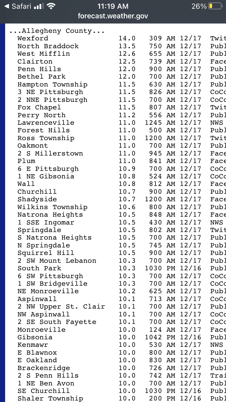
Those calendar day totals underestimate a bit. 2018 was over 11”. Dec 2020 was as well. That airport total wasn’t too representative. Solid foot in many places.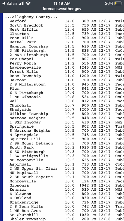
-
Pittsburgh/Western PA Winter 2024-2025 Thread
Burghblizz replied to Rd9108's topic in Upstate New York/Pennsylvania
Some briefly insane snow rates with these squalls cutting through southern Butler Co and Northern AGC. Doesn’t last long - but cool to look at (or worth watching out for if driving) -
lol - no it’s not (I understand the idea of these, but this one isn’t that)
-
Pittsburgh/Western PA Winter 2024-2025 Thread
Burghblizz replied to Rd9108's topic in Upstate New York/Pennsylvania
Crisis averted! Total updated to 27.9”. So call it an extra 1.3” for that missing period, and 3.9” total for that second Sunday batch. -
Pittsburgh/Western PA Winter 2024-2025 Thread
Burghblizz replied to Rd9108's topic in Upstate New York/Pennsylvania
Does seem to be some snow “missing”. Even the current season to date total went from 24” to 26.6” as of this morning. Some of the heavier stuff last night seemed to straddle the airport, but I wouldn’t be surprised if that is adjusted. Saw another report from Moon of 3.5”. -
Pittsburgh/Western PA Winter 2024-2025 Thread
Burghblizz replied to Rd9108's topic in Upstate New York/Pennsylvania
Eventful day with flooding, 50 MPH wind gusts, mini-paste bomb and now snow squalls. NWS total will make a run at 3” (thought I saw 2.6” so far) Will probably wind up over 5” since yesterday. Great winter scenes this weekend - just crappy the first batch got washed away. -
Pittsburgh/Western PA Winter 2024-2025 Thread
Burghblizz replied to Rd9108's topic in Upstate New York/Pennsylvania
Real nicely. It was just thin bands after the initial slug, then that shield really expanded -
Pittsburgh/Western PA Winter 2024-2025 Thread
Burghblizz replied to Rd9108's topic in Upstate New York/Pennsylvania
Real quick inch on the ground already. Not exactly sure of the flip here because I wasn’t near a window, but likely within the last 45 minutes. -
Pittsburgh/Western PA Winter 2024-2025 Thread
Burghblizz replied to Rd9108's topic in Upstate New York/Pennsylvania
Thumping here. Wind driven wet snow. -
Pittsburgh/Western PA Winter 2024-2025 Thread
Burghblizz replied to Rd9108's topic in Upstate New York/Pennsylvania
For midweek - NAM looks like it wants more of a longer duration, steady, WAA type snow. Maybe a more modest…but more realistic “good” solution.