jaxjagman
-
Posts
8,627 -
Joined
-
Last visited
Content Type
Profiles
Blogs
Forums
American Weather
Media Demo
Store
Gallery
Everything posted by jaxjagman
-
Emd of the run and still snowing inW/TN
-
NAM 3K dont show this wild scenario
-
NAM transferred the energy from the GOM to Tn in a couple hours?
-
Man,stronger LLJ
-
Maybe not,more ice this run
-
NAM is slightly strong this run,gonna be a good run for people in the west
-
NAM looks better so far,see what happens
-
Mesoscale model that isnt even that good with severe that far out
-
It brings the LP through Tn,wouldnt trust the HRRR that far out,it usually whiffs
-
Not sure why it made it small,heres the linkhttps://www.wpc.ncep.noaa.gov/discussions/hpcdiscussions.php?disc=qpfhsd
-
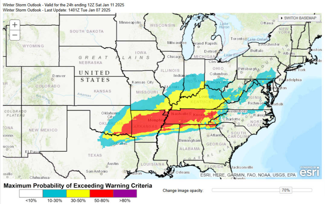
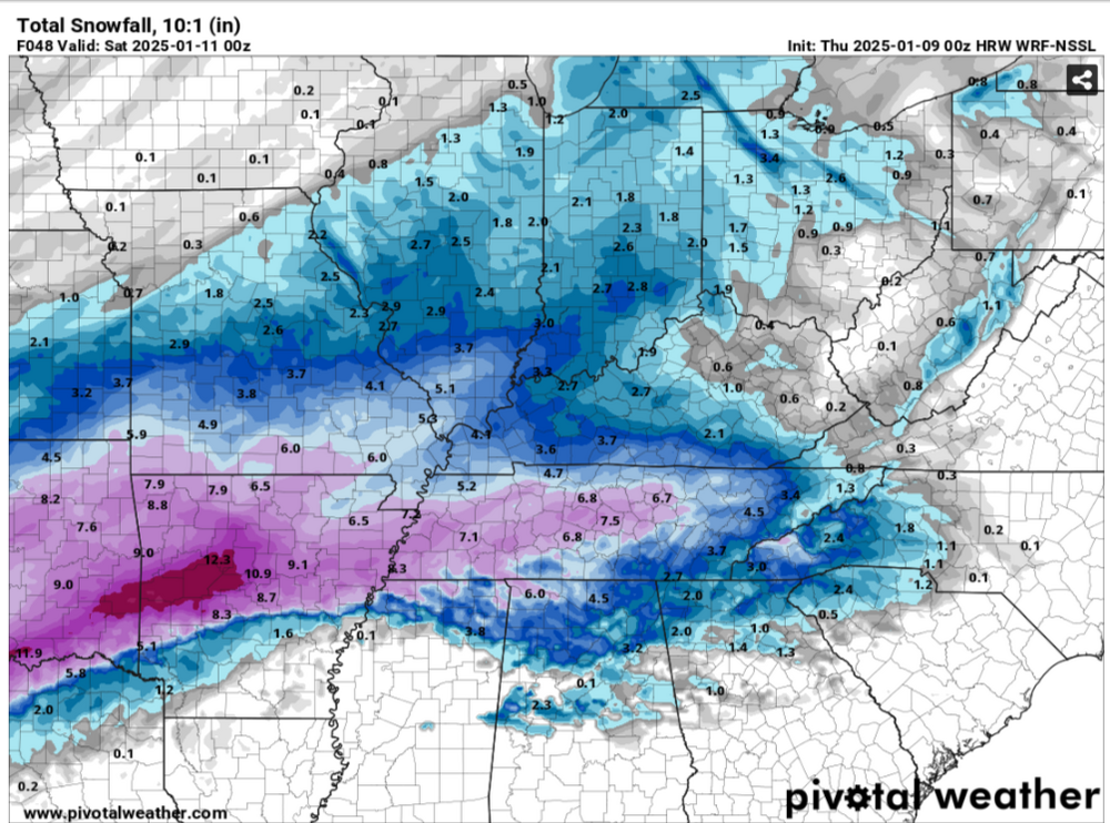
LONG TERM... (Thursday Night through next Wednesday) Issued at 1104 AM CST Wed Jan 8 2025 Not much has changed in the forecast with the upcoming snow event. Models have hinted at a slightly further north track, which may allow for warmer air to move further north as well. This could allow for some rain to mix in with the snow especially near the AL border area. Any rain at all would rob moisture for the snow, and lessen snow amounts in that area. But, a further south track would limit moisture in northern zones, and lower snow amounts in that area. So, this is a difficult forecast in regards to snow amounts. At least the chances for sleet and freezing rain are very low with current model data. GFS and GEFS remain the most aggressive with snow and textbook isentropic lift over most of the day Friday, resulting in the heaviest snowfall. NAM has ramped up a little but remains below the GFS, and the ECMWF and ensembles remain on the lower end. Still, 10th percentile snow amounts are in the 1-2 inch range, and 90th percentile is in the 5 to 7 inch range, so we still have a decent spread between the models. Still have 3 to 6 inches across the mid state, with some locally higher amounts possible especially if any mesoscale bands develop with higher snowfall rates. Some of the CAMs are getting into the onset of the snow and suggest snow could start a little earlier than anticipated by a few hours, but either way, Friday will definitely have travel impacts regardless and travel should be avoided. Temps will likely be cooler if we get the snowfall currently in the forecast, so temps will struggle to get above freezing on Saturday. This will keep roads in rough shape especially on less traveled and secondary roads. Lows Saturday night will be in the teens, but there may be some relief Sunday with weak ridging and getting temps to the upper 30s. But another weak Midwest trough will swing through Sunday night into Monday, and could bring some flurries/light snow to the area. At the very least it will bring cloud cover, so any help from the sun on the roads doesn`t look likely. Lows in the teens/20s are expected each night next week, which any melting will result in re-freezing, keeping travel difficult with black ice on any cleared roads.
-
Then i just looked at the 2m's and its not very cold,so maybe it isnt right
-
Could be right,they will probably be colder because of the elevation,thus better ratios
-
Is the snow map 10:i higher than the Kuchera,might be cutting back on the totals like 5-7:1 maybe,i need to find some better models
-
Not as cold?
-
I dont see how a dry slot would effect us if the storm formed into a trowel not the track of the storm forecasted
-
Put with,edited it to without Stove we need his mojo
-
Its not a winter storm without Stove
-
Nashville disco LONG TERM... (Thursday through next Tuesday) Issued at 1053 AM CST Tue Jan 7 2025 The story for this forecast continues to be the snow potential for Friday. Brief ridging on Thursday ahead of the next trough will warm temps slightly, but still going to remain with cooler temps and highs staying in the 30s. Snow is expected to begin in the west Friday morning with the trough over the Plains working its way east. Peak snowfall looks to be mid morning through the afternoon across most of the mid state, and into the evening to early overnight hours for the Plateau. This will be a quick hit of snow, but right now, models are pretty consistent showing 1 to 4 inches of snow depending on which model you are looking at. The GFS and its ensembles are the most aggressive with snow, and on the higher end of amounts thanks to a stronger trough, and near perfect isentropic lift during the day Friday. Decent Q-vector convergence and upper level support stays around through the day, so the GFS is fully onboard with heavy snow. The ECMWF, its ensembles, and the NAM are still showing snow, but not as aggressive as the GFS/GEFS. Still, broad ensemble consensus is 1 to 4 inches with the latest forecasts for Friday, and the most likely scenario is 2-4 inches area wide. If models start leaning towards the GFS solutions, that will go up, but going the other direction, amounts will go down slightly. Probability of 2 inches or more is roughly 50 to 70 percent area wide. Temps will struggle to get above freezing Saturday, but ridging tries to build in Sunday so that will help with melting snow. For the most part, the remainder of the forecast looks dry, with some light snow possible in the north Monday but agreement and confidence is low. Temps dont look to warm up much next week with highs in the 30s/low 40s and lows in the teens/20s.
-
Quite a few times when you see the LP suppressed down into Mobile Bay , Big Bend these are big winter storms in our Southern Parts,generally QPFS usually leaves us with just light snow here,id feel pretty good if i was around the TN/AL line
-
Look at the Vort,definite a better run that time compared the the 0Z
-
We like live in another world for snow,get a unexpected warm nose or even convection down south turns the faucet off