jaxjagman
-
Posts
8,627 -
Joined
-
Last visited
Content Type
Profiles
Blogs
Forums
American Weather
Media Demo
Store
Gallery
Everything posted by jaxjagman
-
Area Forecast Discussion National Weather Service Nashville TN 1203 PM CST Sun Feb 9 2025 ...New SHORT TERM, LONG TERM... .KEY MESSAGES... Updated at 1200 PM CST Sun Feb 9 2025 - Scattered light rain showers through 9 PM tonight. - Very active weather pattern over the next week, with several chances for rain across Middle TN, but no winter or severe weather expected at this time. - Rises on area creeks and rivers will become possible by next weekend, with 5 to 7 inches of rain forecast through the next 7 days. && .SHORT TERM... (This afternoon through Monday Night) Issued at 1200 PM CST Sun Feb 9 2025 The persistent zonal flow aloft continues today, and this currently coincides with northeasterly surface winds across the Tennessee Valley thanks to high pressure to our north. This setup is favoring isentropic ascent across the region as a frontal surface aloft resides across the I-40 corridor. As such, our clouds and northeasterly flow are keeping temperatures on the cool side, and we have light rain showers emanating from the west. I`ve increased PoPs across Middle Tennessee through ~9 PM despite what will be very little accumulation. A few sleet pellets will be possible as well, but no impacts are expected. It looks to be another cold night tonight with lows in the 30s, after moisture exits to our east. We`re forecast to warm into the upper 40s to lower 50s tomorrow, with help of a little sunshine breaking through in the afternoon. We appear to remain dry tomorrow, but an elongated disturbance aloft will begin to stretch from the Southern Plains toward the Tennessee Valley tomorrow night into Tuesday morning. This system will lead to a widespread soaking of rain as significant moisture transport occurs aloft, overrunning a surface front just to our south. && .LONG TERM... (Tuesday through next Sunday) Issued at 1200 PM CST Sun Feb 9 2025 Rain chances will continue for beginning of the long-term, associated with the system in the area on Tuesday, described above. Flow aloft will become more southwesterly across the region as well. Thus, after a brief reprieve from rain Wednesday morning, a subsequent disturbance is forecast to move into the region Wednesday afternoon as the parade of storm systems across the eastern CONUS continues. Rain chances are quite high once again, and another soaking of rainfall is expected into early Thursday morning. Our latest storm total rainfall from Tue/Wed is generally 2-4", which is doable considering we aren`t expecting any stronger convection which would lead to higher rainfall rates. In fact, highest rainfall amounts are south of I-40 which would benefit ongoing drought in the region. Also, we still expect to stay above freezing throughout this period, so we are not forecasting any wintry precipitation. This appears to mainly impact our friends in KY. For the most part we`ll remain situated between winter weather to our north, and stormy weather to our south. Mid- to upper-level flow will remain quasi-zonal configuration toward the latter part of the period, after a shortwave departs to our east on Friday. By this weekend, medium-range guidance continues to suggest a notable disturbance to eject across the Southern Plains, approaching our region Saturday afternoon into Saturday night. This is currently depicted to contain a 100+ kt mid-level jet streak and substantial height falls which will contribute to cyclogenesis in the Tennessee Valley. All things considered, we`ll have another widespread soaking of rain, and there`s potential for thunderstorms as well. Given the parade of storms throughout the week, this system could tip the scales into some flooding issues across Middle Tennessee which we will continue to monitor and message. Specifics from there are still to be sorted out, including any stronger storm potential. At this time we`re not advertising any, but this will certainly be a more dynamic system. Stay tuned to the forecast.
-
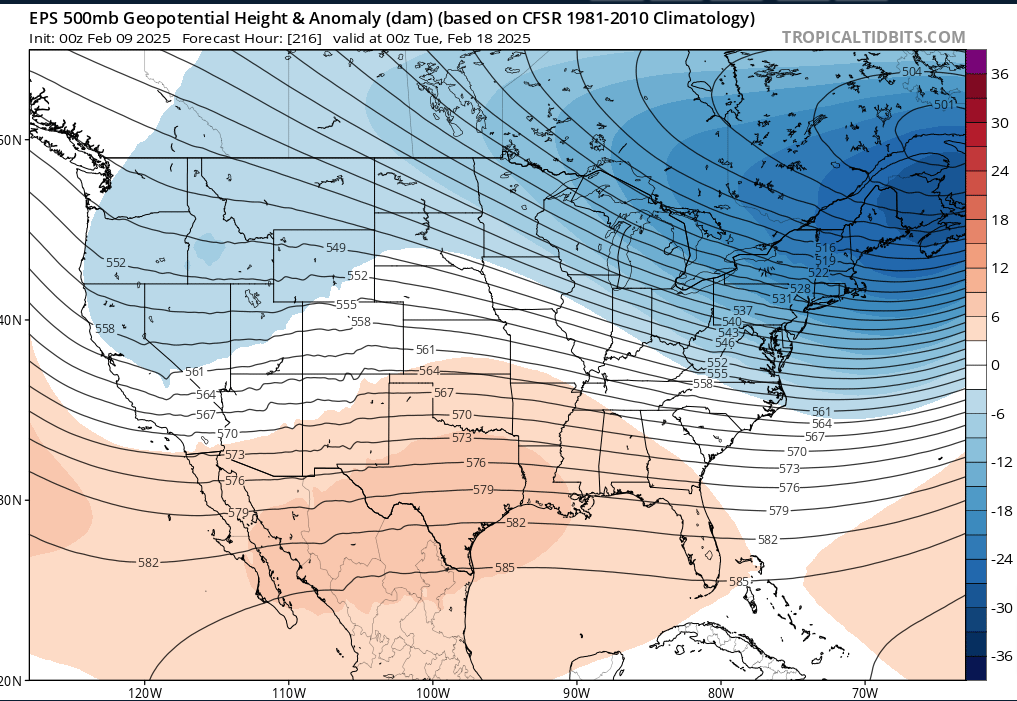
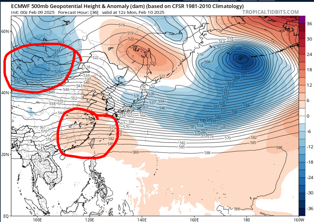
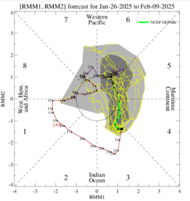
Not sure,i always use the Koreas for us,Japan is basically the east coast and East China is basically west of us.But there is also other teleconnection that wont correlate 1:1.But the maps i show is a trough into Mongolia,which could be a -PNA and heights built up into East China which could possibly be a ridge into the Southern Plains and then you look at the EPS and its very similar.I'm just using these maps as a example +8 days

-
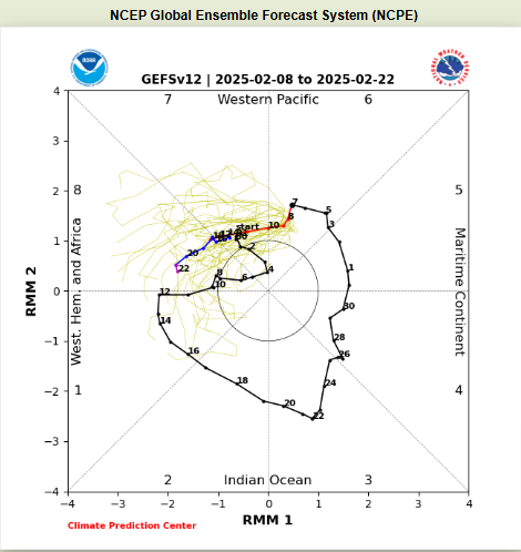
JMO,but the Euro since fall when the MJO gets into the NH the Euro wants to kill the signal and bring back into the COD.It seems to me the Euro is having issues with Kelvin and Rossby waves into the NH into the IO,The MJO shouldnt be getting hung up like the Euro shows, it seems to have a bias of doing this as of late
-
Gonna stick with the CFS,its done well than other models the last couple cycles of the MJO,its once again seeing the MJO get enhanced into the NH+Africa,i wouldnt be surprised to see the IO signal get stronger in the upcoming days
-
https://www.wkrn.com/weather-headlines/feb-4th-most-active-tornado-month/
-
It was already confirmed EF-2
-
https://x.com/i/status/1887699363704582428
-
Looks like its going to hit Sunbright if it holds
-
Could be a cell south of that trying to go
-
URGENT - IMMEDIATE BROADCAST REQUESTED Severe Thunderstorm Watch Number 4 NWS Storm Prediction Center Norman OK 730 PM EST Thu Feb 6 2025 The NWS Storm Prediction Center has issued a * Severe Thunderstorm Watch for portions of Southeast Kentucky Northeast Tennessee Extreme Southwest Virginia * Effective this Thursday night from 730 PM until Midnight EST. * Primary threats include... Scattered damaging wind gusts to 70 mph possible Scattered large hail events to 1.5 inches in diameter possible A tornado or two possible SUMMARY...Scattered intense storms will track southeastward across the watch area for the next few hours, capable of hail and damaging winds. A tornado or two is also possible. The severe thunderstorm watch area is approximately along and 45 statute miles north and south of a line from 50 miles northwest of Knoxville TN to 30 miles north northeast of Hot Springs NC. For a complete depiction of the watch see the associated watch outline update (WOUS64 KWNS WOU4).
-
Could be dying now,running into the mountains
-
Looks better now ,might be headed towards Sunbright
-
Most models weren't showing a strong inversion until recently,might say chalk one up for the GFS.
-
Mean while in Japan https://english.news.cn/20250204/8bdc664a92474df2829e2ee02cba7d7f/c.html#:~:text=TOKYO%2C Feb. 4 (Xinhua,snow depth of 1.2 meters.
-
National Weather Service Nashville TN 1156 AM CST Tue Feb 4 2025 ...New SHORT TERM, LONG TERM... .KEY MESSAGES... Updated at 1155 AM CST Tue Feb 4 2025 - 70-90% chance for rain Wednesday PM into Thursday, with a 30-40% chance for thunderstorms. Marginal risk for severe storms. - Showers and scattered thunderstorms this weekend. - Cooler temperatures next week. && .SHORT TERM... (Rest of today through Wednesday) Issued at 1155 AM CST Tue Feb 4 2025 A cold front was dropping southward very slowly across the Mid State today. On the cool side of the boundary, low clouds were accompanied by areas of fog and drizzle, particularly north and northwest of Nashville where temperatures were in the 40s. Meanwhile, our southeast areas from Crossville to Manchester had mainly sunny skies and temperatures in the lower 60s. The front will continue to settle southward through tonight with mainly cloudy skies area-wide and lows in the 40s. Slight warm advection over the boundary will begin late tonight, possibly resulting in a few light showers. For Wednesday through Wednesday night, warm advection will increase as northern and southern stream waves come our way in zonal flow and a surface low pressure system develops over the plains. The effects of the warm front will come mostly late Wednesday afternoon and evening. Showers will become widespread and there will be embedded thunderstorms. Regarding severe storm potential, we are under a Marginal Risk (level 1 out of 5). The risk outline is mainly across the north half of Middle Tennessee for Wednesday evening. By late Wednesday, models are in good agreement with strong deep layer shear of 40-55KT area- wide along with ML capes of 300-500 J/kg. Lapse rates are unimpressive, but the bigger issue will be limited surface based instability under extensive pre-existing cloud cover. There will be a modest push northward of 60+ dew points, but the main action appears to be aloft. This means we may see a few cells with rotation, but low potential for actual severe wx. Even with all the limitations, mention of the severe risk seems reasonable given the conditional potential- meaning IF any strong cells form and become surface based, strong wind gusts will be possible and unfortunately, a tornado cannot be ruled out given the strongly curved hodographs. Later models may offer better insight and allow us to either step up or back off on the potential. Otherwise, soaking rainfall Wednesday PM through Thursday will result in one half to 1 inch of rain area-wide. Temperatures will stay warmer than normal with 60s to lower 70s for highs and lows Wednesday night in the 50s to lower 60s. &&
-
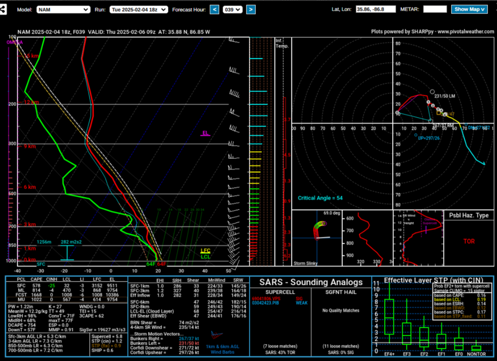
Day 2 Convective Outlook NWS Storm Prediction Center Norman OK 1134 AM CST Tue Feb 04 2025 Valid 051200Z - 061200Z ...THERE IS A MARGINAL RISK OF SEVERE THUNDERSTORMS OVER PORTIONS OF KENTUCKY AND TENNESSEE... ...SUMMARY... A conditional risk of a few strong or severe storms exists over parts of Kentucky and Tennessee late Wednesday. ...Synopsis... On Wednesday, an upper trough will be situated over the Pacific Northwest, with an early disturbance lifting into MT with height rises over OR. Otherwise, a westerly flow regime will exist across the rest of the CONUS, with various embedded waves. One such lead wave will move across the central Plains during the day, and will quickly move into the mid MS and lower OH valley during the evening and overnight. At the surface, high pressure will be strongest across the Great Lakes and Northeast, but another lobe of surface ridge will extend into the Southeast. Modest southerly low-level winds will maintain a moistening air mass from TX into the TN Valley, as a warm front lifts across TN and into KY. Overnight, a cold front associated with the midlevel wave will be near the OH River between 06-12Z, likely interacting with the moist plume. ...KY/TN/MS/AL... During the day, a few thunderstorms may develop within the deepening moist plume from northern MS/AL into Middle TN. This will occur with limited surface heating, and primarily in association with weak warm advection and moisture extending up through 700 mb. Midlevel lapse rates will not be very steep, and general thunderstorms appear most likely here. Overnight, as the midlevel wave and cold front approaches from the west, lift will interact with the low 60s F dewpoints and MLCAPE over 500 J/kg, with several thunderstorms possible. The main uncertainty for severe risk is regarding low-level lapse rates, however, shear will be strong with long hodographs and effective SRH possibly exceeding 400 m2/s2. As such, a conditional risk of a supercell or two will exist, including brief tornado risk as well as strong wind gusts. ..Jewell.. 02/04/2025
-
Thought Middle Tn would get put in a slight risk the last update but they left us in a marginal still
-
National Weather Service Nashville TN 820 PM CST Mon Feb 3 2025 ...New UPDATE... .KEY MESSAGES... Updated at 813 PM CST Mon Feb 3 2025 - Near record warmth today. - Scattered showers and thunderstorms Wednesday and Thursday. - More showers this weekend. && .UPDATE... Issued at 813 PM CST Mon Feb 3 2025 Nashville`s high temperature reached 74 degrees this afternoon -- just 1 degree shy of tying the record high for this date. Tomorrow won`t be quite as warm as today, but will still be warm for early February. We expect a surface boundary to slip through the mid state later tonight and early Tuesday. We don`t expect any showers with the fropa, but there will be some additional cloudiness along with cooler temperatures. In the meantime, the evening sounding from OHX shows a dry atmosphere in place, and the moisture coming in with tonight`s front won`t be enough to give us measurable precipitation. So we`ll have to wait until Wednesday for the next appreciable chance for rain.
-
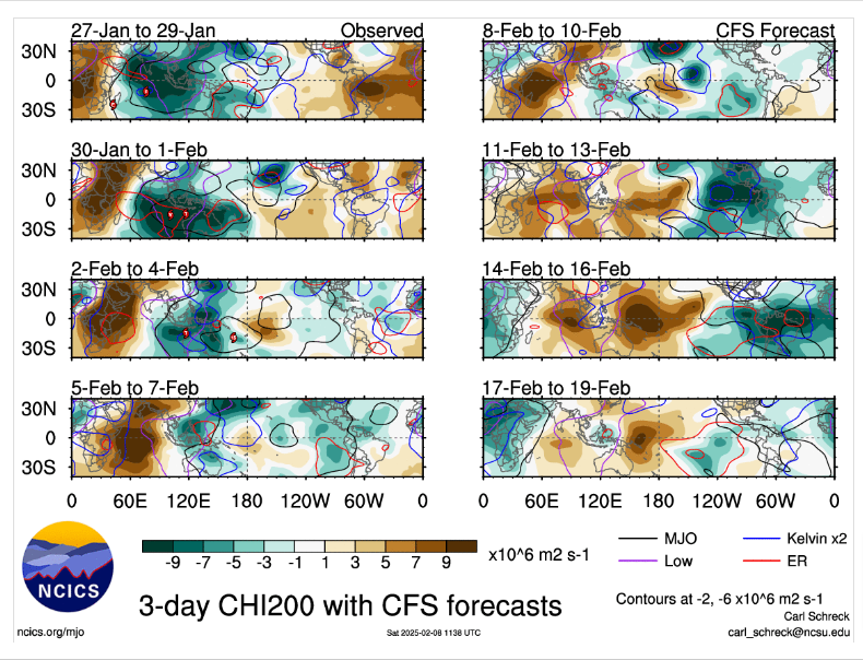
Guess we will know more in the next few days,but its a train wreck into the IO right now with Rossby and Kelvin waves.But i'm starting to like the GEFS.It seems like the EWB west of the IDL will start to get broke down into early Feb this should/could strenghten the MJO signal into the WP.
-
No chance of snow here,thermals are to warm and when it gets cold enough its low PWS and dry air so the moisture has moved out
-
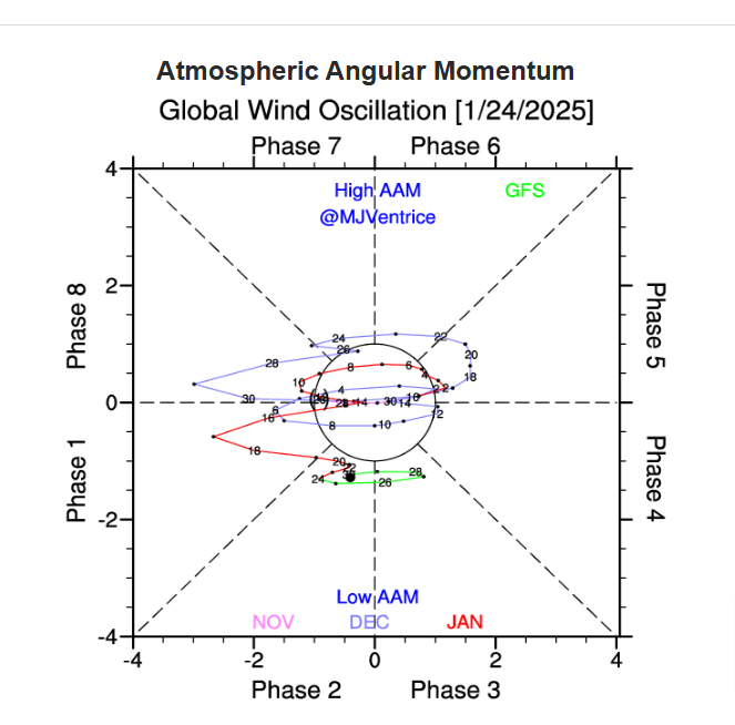
I'm with you and Carver,until the MJO gets out of the IO we could see something different,but right now every model shows about the same thing.I think we started to see the pattern change around the 15th of this month,now for the first time the AAM is showing its gonna stay low,we had our winter storm recently with -NAO and its been that way for the most part all winter now its positive,no signs its gonna change anytime soon.For the first time this winter it seems to be coupled with NINA and not so as it has been
-
Models are showing today SO far right now the best chance for severe would be the lower MV up into the Mid South into wk2 kinda like PV maps are showing up top,i'm just looking at DP's right now
-
Looks severe into the lower MV into the Mid South possibly into the first wk of Feb possibly.If the MJO gets hung out into the WP like some models seem to be hinting at we might have to find the flooding thread buried somewhere
-
Euro has a boundary lifting though the Tn Valley around next weekend,if it right then would be also a line of severe storms possible with DP'S 60+all the way up into the lower OV
-
Good for the east,we've at least gotten moisture here recently South Drought Summary Temperatures were cooler than normal for the region this week with most areas 5-10 degrees below normal. It was mostly a dry week throughout the region with only areas of southern Texas recording above-normal precipitation. Some areas are pushing 60 or more days without any significant precipitation in portions of Oklahoma and Texas, but as it is climatologically the driest time of the year for some of these areas, drought degradation has been slow. Changes this week included an expansion of abnormally dry conditions over extreme northwest Arkansas and central Texas. Moderate drought also expanded over portions of central Texas due to reports of crop losses due to lack of soil moisture in the region. Extreme drought expanded along the Big Bend of Texas where hydrological indicators are supporting the expansion. Some improvements to the severe and extreme drought were made in middle Tennessee, but abnormally dry conditions were expanded in the southwest portion of the state.