

jaxjagman
-
Posts
8,627 -
Joined
-
Last visited
Content Type
Profiles
Blogs
Forums
American Weather
Media Demo
Store
Gallery
Everything posted by jaxjagman
-
GFS is showing a chance of severe Monday night into the Mid South,West Tenn,but this could also just be a shortwave its showing and might not be there next run seemingly,Tuesday could get interesting,GFS keeps showing alot of invergence into the warm sector,but this could be typical GFS bias at this range.Climo the best severe and tornado chance would be into Al/MS.
.thumb.png.87aaf121fbd7aa3c67f2d105e02c404d.png)
.thumb.png.ccbc59ea16a2e0aa1b81a9c8b5e6bf6e.png)
.thumb.png.a106d18415c3e6697c82247235c331b8.png)
-

February 2024 mid/ long range
jaxjagman replied to Holston_River_Rambler's topic in Tennessee Valley
GTH Outlook Discussion Last Updated - 02/20/24 Valid - 02/28/24 - 03/12/24 RMM observations show a westward retreat of the MJO signal over the Western Pacific earlier this month, but the MJO has since resumed its eastward propagation and has moved into phase 8 (Western Hemisphere) in RMM space. Consistent with model guidance since last week, a much weakened MJO is generally favored in the RMM forecasts, with model solutions showing the signal mostly remaining within the unit circle during the next two weeks. However, there is some question as to whether this weakening is reflective of a disorganizing MJO or the removal of the 120-day mean which is strongly skewing the MJO signal to the right in RMM space. Upper-level velocity potential anomaly and OLR forecasts suggest the latter, which depict a more coherent MJO moving forward. Anomalous lower-level westerlies forecast continue to enhance probabilities for tropical cyclone (TC) development for the southwestern Indian Ocean through early March. It has been an active week for TCs around the globe, with 5 TCs that formed in 4 different basins. In the South Pacific, TC 15P formed east of the Cook Islands on February 15 and quickly dissipated. In the Australia region, TC Lincoln formed in the Gulf of Carpentaria on February 15 and moved inland quickly, bringing heavy rain to northwestern Australia. In the South Indian Ocean, on February 17 TC Djoungou formed east of Madagascar. It moved southwestward and became very strong before weakening and transitioning to an extratropical system. On February 18 TC Eleanor formed, also east of Madagascar. It is currently still active, meandering near Mauritius, and is currently forecast to eventually move towards Madagascar. For the latest information on TC Eleanor please refer to the Joint Typhoon Warning Center (JTWC). Finally, a rare South Atlantic TC formed southeast of Rio de Janeiro on February 18. It strengthened and was named Akara on February 19, and is currently tracking south. Despite a relatively weak RMM signal among forecast models, other indicators of MJO activity suggest a stronger MJO than might otherwise be expected. Upper-level velocity potential anomaly forecasts portray a weak to moderate MJO taking shape during weeks 2-3, with increasing anomalous divergence aloft over Africa and into the Indian Ocean as the forecast period progresses. This results in a moderate probability (>40%) for TC activity in the southwestern Indian Ocean during weeks 2-3. Interestingly, Indian Ocean MJO (phases 2 and 3) events historically lead to decreased chances for TC formation near Australia and the Maritime Continent but guidance from both the GEFS and ECMWF suggest a higher chance for TC genesis during the forecast period across the northern Australian coast than might otherwise be indicated, possibly due to Rossby or Kelvin wave interference. The large-scale environment is expected to remain weakly favorable for TC development over the southeastern Indian Ocean during week-3, and 20% chances for TC genesis are issued for portions of the northern Australian coast. The precipitation outlook for weeks 2 and 3 is based on potential TC activity, the anticipated state of the MJO, and a skill-weighted consensus of GEFS, CFS, Canadian, and ECMWF ensemble mean solutions. Above-normal precipitation continues for the Equatorial Eastern Pacific for both weeks, a response to the El Nino conditions, while suppressed precipitation is favored to the north and south of the El Nino-enhanced precipitation. Continued below-normal precipitation is indicated for portions of northern South America for week-2, and above-normal temperatures are likely for eastern Brazil during both weeks. Above-normal precipitation becomes more likely over the western Indian Ocean as the next MJO cycle begins during the forecast period. During week-2, above-normal temperatures are likely for the eastern U.S., much of Brazil, portions of western Australia, and much of southern Africa, while below-normal temperatures are favored for eastern China.- 750 replies
-
- 4
-

-

-
- snow elk
- wooly worm
- (and 1 more)
-
February 2024 mid/ long range
jaxjagman replied to Holston_River_Rambler's topic in Tennessee Valley
MJO is going into 1-2.png.7b90ff602143b5434df1a563f473ed89.png)
- 750 replies
-
- 1
-
-
- snow elk
- wooly worm
- (and 1 more)
-
February 2024 mid/ long range
jaxjagman replied to Holston_River_Rambler's topic in Tennessee Valley
https://www.cpc.ncep.noaa.gov/products/predictions/WK34/- 750 replies
-
- 2
-
-
- snow elk
- wooly worm
- (and 1 more)
-
February 2024 mid/ long range
jaxjagman replied to Holston_River_Rambler's topic in Tennessee Valley
Actually matches up pretty decently with what the EPS is showing which would be into the 2nd week of March,least it does today.thumb.png.58b368f96f119152d6fde2902860a2a3.png)
- 750 replies
-
- 1
-
-
- snow elk
- wooly worm
- (and 1 more)
-
February 2024 mid/ long range
jaxjagman replied to Holston_River_Rambler's topic in Tennessee Valley
About to move to severe with Jeff...not sure how much is left in this winter.png.b1067aa8e23979183215bd95618e6de2.png)
- 750 replies
-
- 1
-
-
- snow elk
- wooly worm
- (and 1 more)
-
February 2024 mid/ long range
jaxjagman replied to Holston_River_Rambler's topic in Tennessee Valley
This was yesterday.png.051acb1ea4a9d901706c7ba99421ec7c.png)
- 750 replies
-
- 1
-
-
- snow elk
- wooly worm
- (and 1 more)
-
Its now in the Euro range but this far out use with caution
.png.38d3ad8f1c16637da388ca2bb0c4941f.png)
-
February 2024 mid/ long range
jaxjagman replied to Holston_River_Rambler's topic in Tennessee Valley
This is what the Euro showed 2 days ago,so it fluctuates daily,But there still should be a trough in the east into March by the looks in East Asia.thumb.png.89292f4f042a3b9e0cd172288b520409.png)
- 750 replies
-
- 1
-
-
- snow elk
- wooly worm
- (and 1 more)
-
February 2024 mid/ long range
jaxjagman replied to Holston_River_Rambler's topic in Tennessee Valley
Still believe this is a colder pattern as we get into March,2m's map is the Euro.png.4a9cab263bc402e33eeda0cec039352f.png)
.thumb.png.ace11da2fdf45b155e99200a7e0a98e8.png)
- 750 replies
-
- 3
-
-
-
- snow elk
- wooly worm
- (and 1 more)
-
February 2024 mid/ long range
jaxjagman replied to Holston_River_Rambler's topic in Tennessee Valley
That's actually brutal if you want cold by the Euro this afternoon,looks more severe now into March with a trough trailing it.Plus the Euro mean more members are trying and skip the cold phases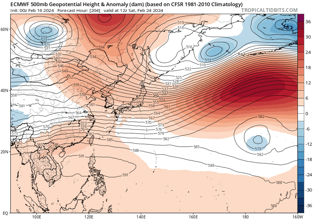
.png.a38154b2513deed289fa9e2599d4a15b.png)
- 750 replies
-
- 3
-
-
-

-
- snow elk
- wooly worm
- (and 1 more)
-
February 2024 mid/ long range
jaxjagman replied to Holston_River_Rambler's topic in Tennessee Valley
I'm not knocking Jeffs map either,it's stamped the 8-15th,it certainly could look like that at one point- 750 replies
-
- 1
-
-
- snow elk
- wooly worm
- (and 1 more)
-
February 2024 mid/ long range
jaxjagman replied to Holston_River_Rambler's topic in Tennessee Valley
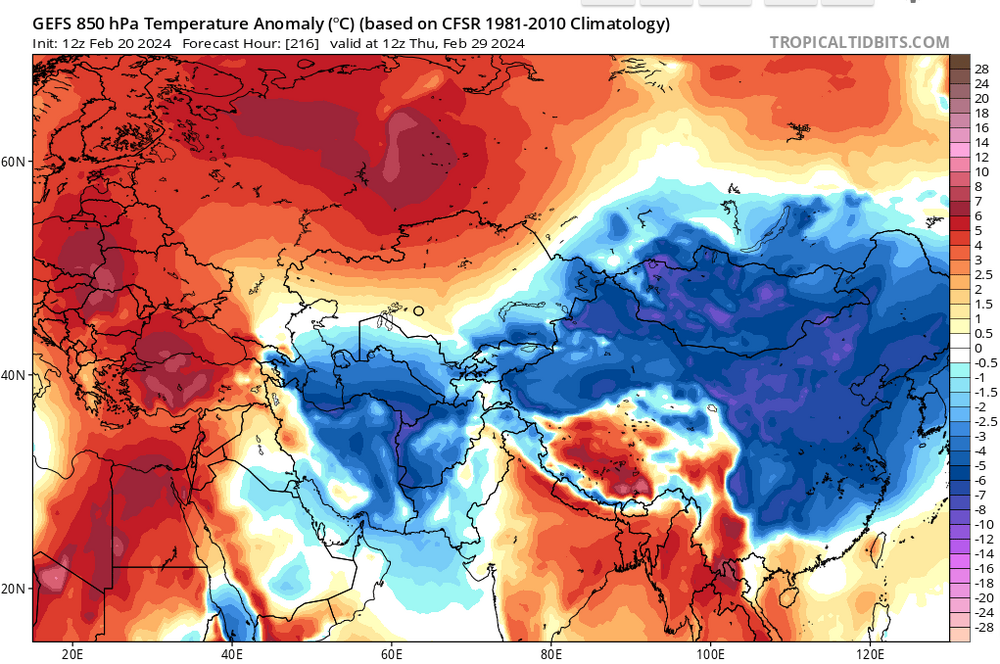
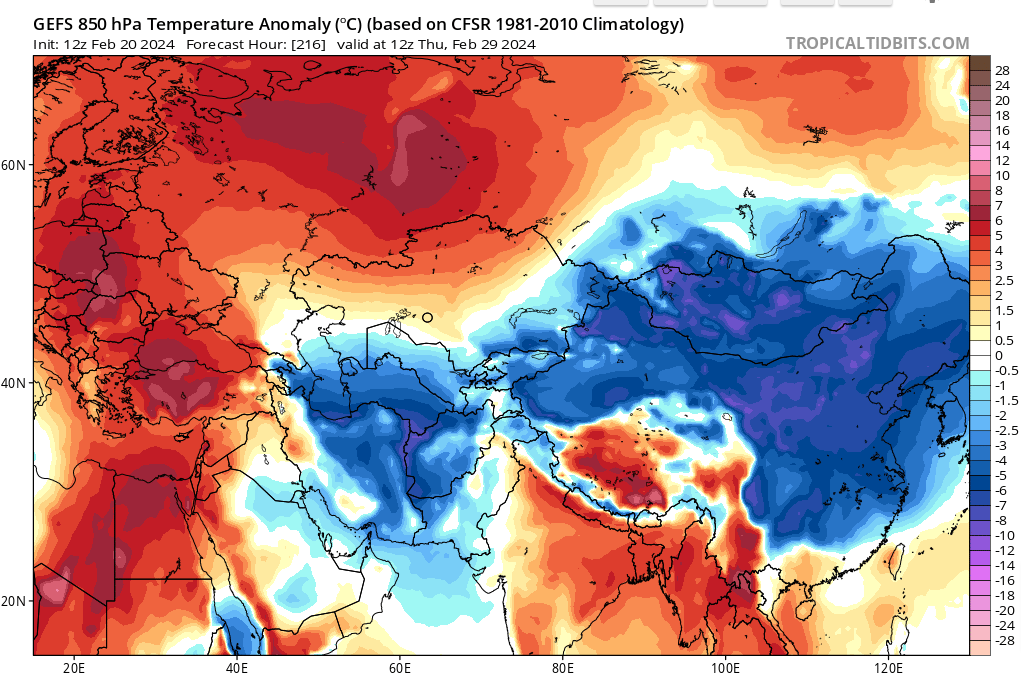
I still think it should turn colder as we get into the first week of March. There is a ridge building on top of Kazakhstan into the Urals all the long range models show this with basically troughing into Mongolia,Koreas and even down into the East China Sea,that shouldnt be a warm look.thumb.png.6471f70af5dbe376d73be9e96e735882.png)
- 750 replies
-
- 2
-
-
- snow elk
- wooly worm
- (and 1 more)
-
February 2024 mid/ long range
jaxjagman replied to Holston_River_Rambler's topic in Tennessee Valley
That was a BIG ridge into the Atlantic for Feb,2018,that's like a summer time ridge and not winter time- 750 replies
-
- 2
-
-
- snow elk
- wooly worm
- (and 1 more)
-
February 2024 mid/ long range
jaxjagman replied to Holston_River_Rambler's topic in Tennessee Valley
GEFS looks like a couple days away but by the JMA we already hit the Major.png.5845881ad7e1fa6fe7a77b8031490eb9.png)
- 750 replies
-
- 2
-
-
- snow elk
- wooly worm
- (and 1 more)
-
February 2024 mid/ long range
jaxjagman replied to Holston_River_Rambler's topic in Tennessee Valley
If you look at South Korea they are far away of course BUT they have similar weather patterns like we do here in winter to an extentent we rely on blocking,etc.etc. To get cold in the winter months South Korea relies on the Urals/Subartic blocking.Plus like we do we want to see a -AO,but to an extent the -AO doesnt have to be as strongly negative there When it gets cold and as of all those features above,you start to see these wave trains moving through South Korea and the MJO is in phase 2-3.The lenght of the cold is similar to us in Tn.We can get cold in Nov-March but the coldest weather in South Korea is similar to us Jan-Feb,it can have a longer duration and effects and the same should be said in Nov and March shorter lenght stays. But,its not looking as cold as it was the past couple days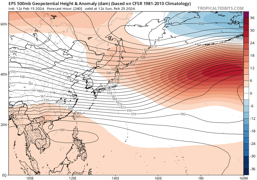
- 750 replies
-
- 1
-
-
- snow elk
- wooly worm
- (and 1 more)
-
February 2024 mid/ long range
jaxjagman replied to Holston_River_Rambler's topic in Tennessee Valley
Plus if you follow the velocity this should be where its at with the map above,for now.png.fa16c6f812e2f5cfba0660933a3a5db2.png)
- 750 replies
-
- 1
-
-
- snow elk
- wooly worm
- (and 1 more)
-
February 2024 mid/ long range
jaxjagman replied to Holston_River_Rambler's topic in Tennessee Valley
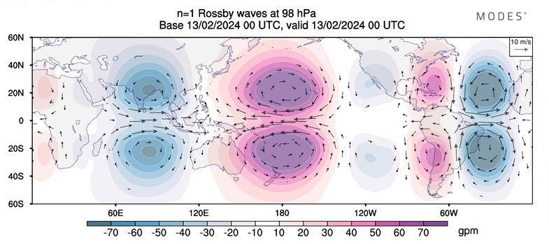
IMO the MJO is getting into NA right now and it isnt even close to the WP like some RMM"S show.thumb.png.838a5f117aac55460f75baa55d1f472c.png)
- 750 replies
-
- 3
-
-
-
- snow elk
- wooly worm
- (and 1 more)
-
February 2024 mid/ long range
jaxjagman replied to Holston_River_Rambler's topic in Tennessee Valley
Some of the models look better,more 1-40.GFS isnt bad in parts of E/TN- 750 replies
-
- 3
-
-
- snow elk
- wooly worm
- (and 1 more)
-
February 2024 mid/ long range
jaxjagman replied to Holston_River_Rambler's topic in Tennessee Valley
BY the GFS winter returns in East Asia,not to the degree the other models shows,but they still show it..thumb.png.1c0c3e8c5bd3f8434870018a6be91c7e.png)
- 750 replies
-
- 2
-
-
- snow elk
- wooly worm
- (and 1 more)
-
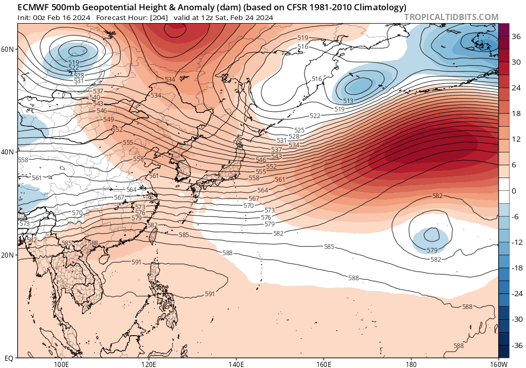
In the next couple days the models show a big ridge starts to get going into the Sea of Japan into Northern Japan,with a trough trailing behind it. This seemingly towards the end of the month of Feb would build a ridge into the NE and then we should start to see height rises and a return flow from the SW.No clue where severe would set up even if it does but it does seem to be a time frame to watch closely.

-
February 2024 mid/ long range
jaxjagman replied to Holston_River_Rambler's topic in Tennessee Valley
The end of the month right now looks more severe than winter.Big ridge is going to sit on top of Japan and head east,it seems possible like the GFS has been showing this is going to be a fairly strong ridge to our NE which in return we would see the heights rise,JMHO.thumb.png.5e4d62a28450fed1632e7d50b20ae83a.png)
- 750 replies
-
- 4
-
-
-
- snow elk
- wooly worm
- (and 1 more)
-
February 2024 mid/ long range
jaxjagman replied to Holston_River_Rambler's topic in Tennessee Valley
- 750 replies
-
- 1
-
-
- snow elk
- wooly worm
- (and 1 more)
-
February 2024 mid/ long range
jaxjagman replied to Holston_River_Rambler's topic in Tennessee Valley
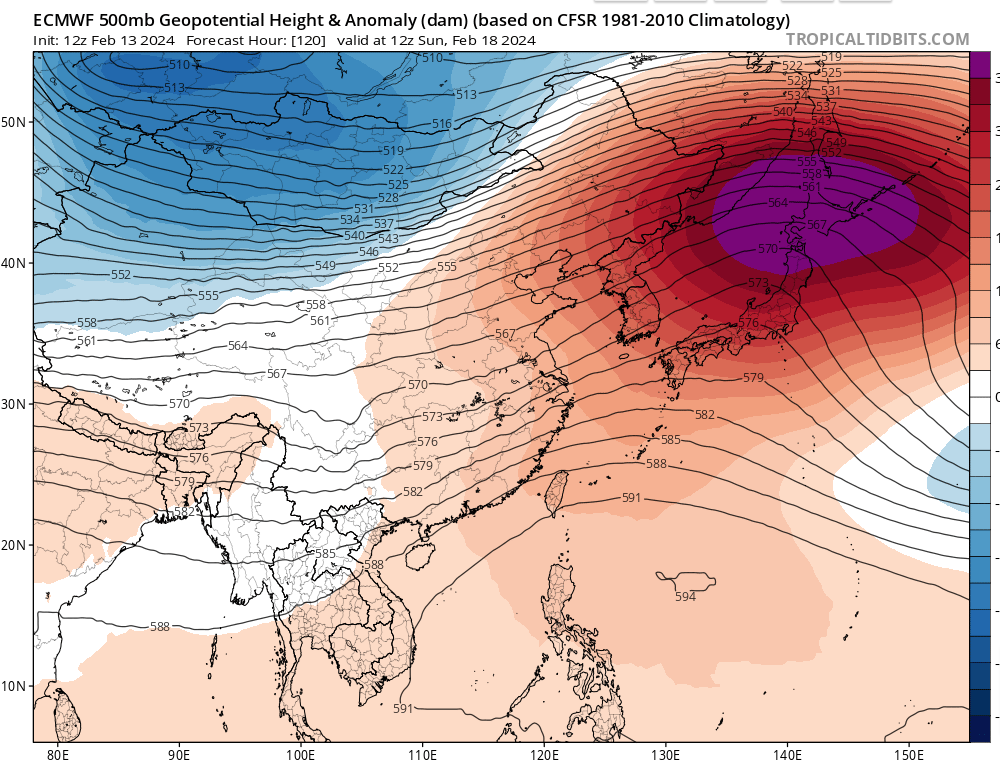
GTH Outlook Discussion Last Updated - 02/13/24 Valid - 02/21/24 - 03/05/24 Since earlier this month, RMM observations show a westward retreat of the MJO signal over the western Pacific, followed by the resumption of a more canonical eastward propagation where it has recently entered the Western Hemisphere (phase 8). The observed behavior appears to be tied to a fairly strong Rossby wave activity in the global tropics which led to a breakdown of the wave-1 spatial pattern in the upper-level velocity potential anomaly fields during the past week. Looking ahead, RMM forecasts have been consistent in favoring a weakened and incoherent MJO through late February, as models remain nearly unanimous with the signal falling within the unit circle in the next two weeks. However, analysis of several MJO variable forecasts reveal a more coherent MJO perspective, and the thinking is that the disorganizing MJO favored in the RMM forecasts may be more of an undesired effect of RMM methodology. A comparison of RMM indices with and without the 120-day running mean shows a sharp left-to-right shift of values in phase space, where the positive Indian Ocean Dipole (+IOD) event that peaked this past fall appears to be exerting a dominating influence in the mean. Because this low frequency response is no longer evident in the tropical circulation (namely, in the absence of enhanced lower-level easterlies over the Indian Ocean), the RMM forecasts may be overcorrecting themselves to the right along the RMM 1 axis, where the eastward propagating signals favored in the Western Hemisphere (phases 8 and 1) are actually higher in amplitude than what is being depicted. As a result, this would suggest stronger MJO activity in the outlook, which is supported by upper-level velocity potential anomaly forecasts favoring more of a wave-1 pattern during the next several weeks. Though, it should be noted that even with this RMM biasing, there remains some uncertainty with the evolution of the MJO given a tendency in the model solutions for faster propagation speeds. This is still contributing to high ensemble spread, placing the enhanced envelope at different phases at the longer leads, which is also featured in the upper-level velocity potential forecasts between the ECMWF and GEFS. Regardless of these differences with timing, the large-scale environment is expected to be favorable for tropical cyclogenesis over the southern Indian Ocean, with increasingly less favorable conditions for additional Tropical Cyclone (TC) formation over the South Pacific heading into early March.- 750 replies
-
- 4
-
-
-
- snow elk
- wooly worm
- (and 1 more)
-
February 2024 mid/ long range
jaxjagman replied to Holston_River_Rambler's topic in Tennessee Valley
That was a nice little storm,some intense snow with flakes over a half dollar and thundersnow,to bad it's already about to end- 750 replies
-
- 7
-
-
- snow elk
- wooly worm
- (and 1 more)
.png.e0cfa4e49a07d3142f8226866828787f.png)
.png.e7817f16ff0831598d83b989d0ae16be.png)
.png.05881b5d5f1f0b8de7e8c8129eaf2aef.png)
.png.8afd8c49d55fb8b17bb836d4ea436800.png)
.png.b97bb54f4329eebaee1b7942d75e4ab8.png)
.png.84a0826d89b8d2d5fa222f876585ad48.png)
.png.43302fdc89a31cef50a6577941ade8d8.png)

.png.7ea5f16de3b68bddb745f7347b917da3.png)
.png.e4e5522e1aec8d88172dbac7d83befa1.png)
.png.7c6c56db0c841c7e5df730dd33456a86.png)