

jaxjagman
-
Posts
9,172 -
Joined
-
Last visited
Content Type
Profiles
Blogs
Forums
American Weather
Media Demo
Store
Gallery
Everything posted by jaxjagman
-

December 2025 Short/Medium Range Forecast Thread
jaxjagman replied to John1122's topic in Tennessee Valley
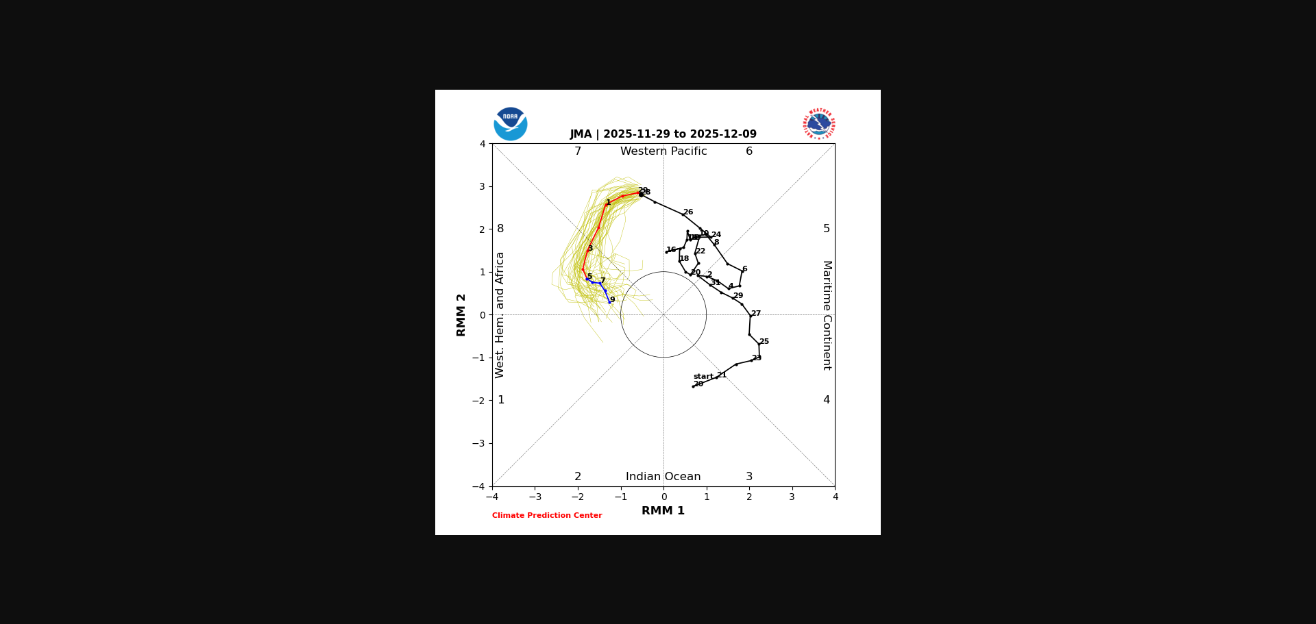
Euro Mean today,i still think you stick with the JMA right now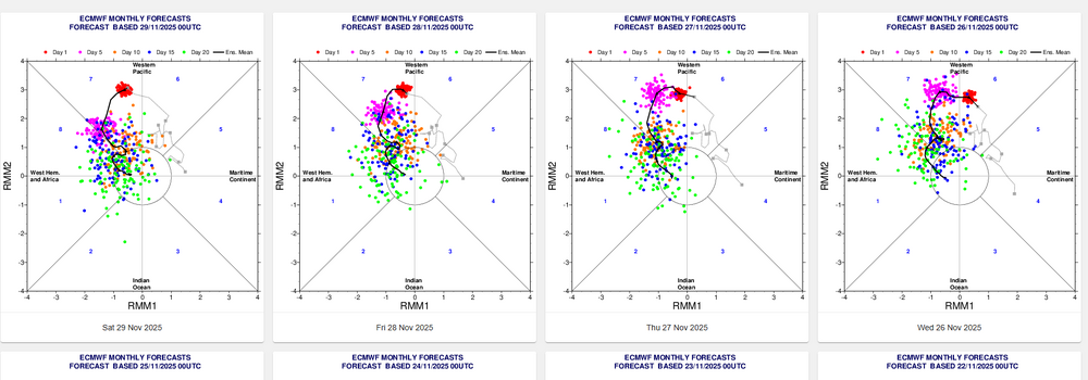
-
December 2025 Short/Medium Range Forecast Thread
jaxjagman replied to John1122's topic in Tennessee Valley
Its just my opinion but when the SOI dropped pretty good around the 23rd then rose before Thanksgiving and the dropped again after,this pattern could should more than likely look like this into East Asis into the first week of Dec,it wouldnt effect our weather until right before the mid month of Dec 29 Nov 2025 1011.21 1008.95 -3.95 14.40 8.89 28 Nov 2025 1011.09 1008.70 -3.12 14.81 8.88 27 Nov 2025 1011.74 1008.55 1.97 15.52 9.00 26 Nov 2025 1012.11 1006.05 20.23 16.24 9.20 25 Nov 2025 1009.58 1005.50 7.63 16.34 9.25 24 Nov 2025 1007.56 1004.90 -1.40 17.10 9.38 23 Nov 2025 1009.73 1000.85 38.17 17.97 9.60 22 Nov 2025 1011.59 1003.75 31.56 17.51 9.41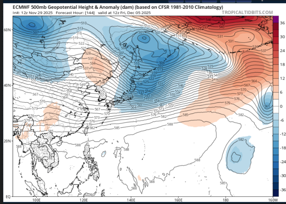
-
December 2025 Short/Medium Range Forecast Thread
jaxjagman replied to John1122's topic in Tennessee Valley
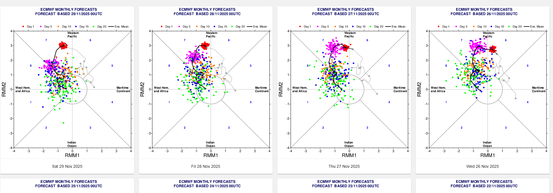
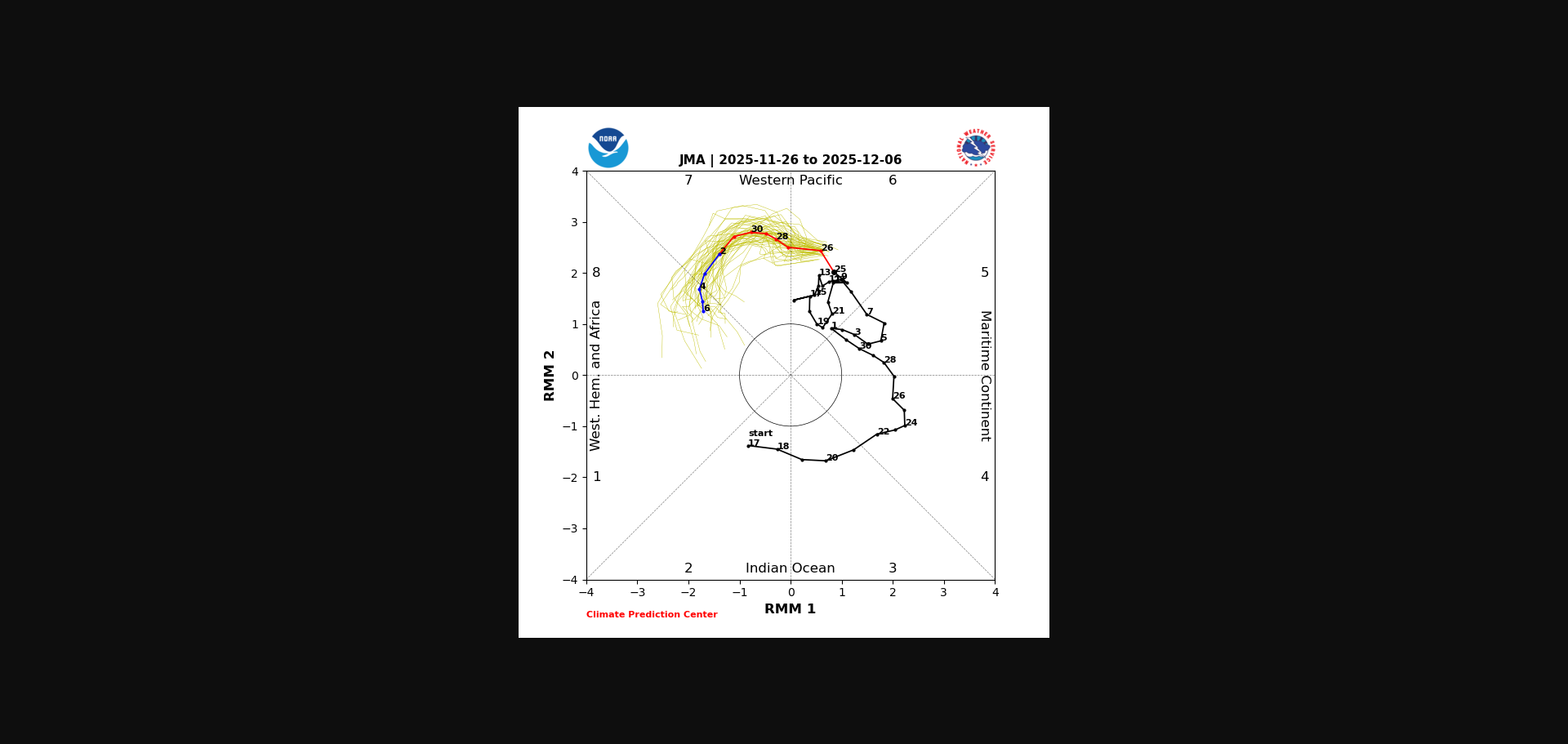
IMHO out in the Pac there is alot of stuff going on with Rossby and Kelvin waves,this is why all the models seem to be struggling with the RMM,even the JMA which has been more tightly bunched is now showing more spread today.You'll more than likely in the next few days see some swings in modeling
-
December 2025 Short/Medium Range Forecast Thread
jaxjagman replied to John1122's topic in Tennessee Valley
Few days ago it was showing a WWB east of the IDL,where did it go..lol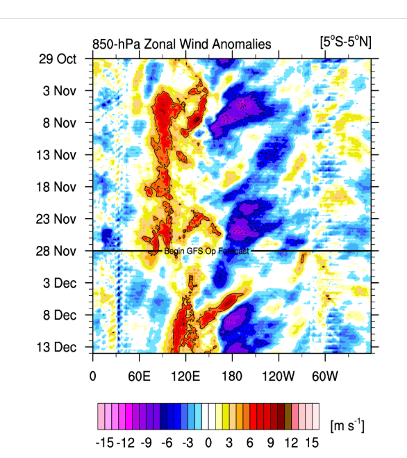
-
December 2025 Short/Medium Range Forecast Thread
jaxjagman replied to John1122's topic in Tennessee Valley
No words needed where the MJO is today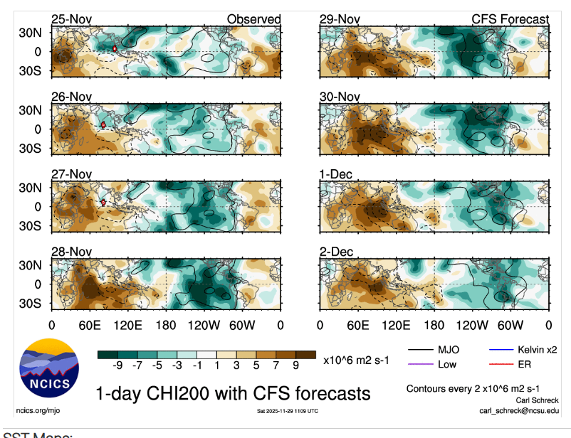
-
December 2025 Short/Medium Range Forecast Thread
jaxjagman replied to John1122's topic in Tennessee Valley
We always here in Middle Tn get hosed by inverted troughs,still remember when we had a Winter Storm Warning that was right before the snow dome talk came in,was suppose to get 3-5" and the models missed the inverted trough and we just got rain instead,because it missed the warm nose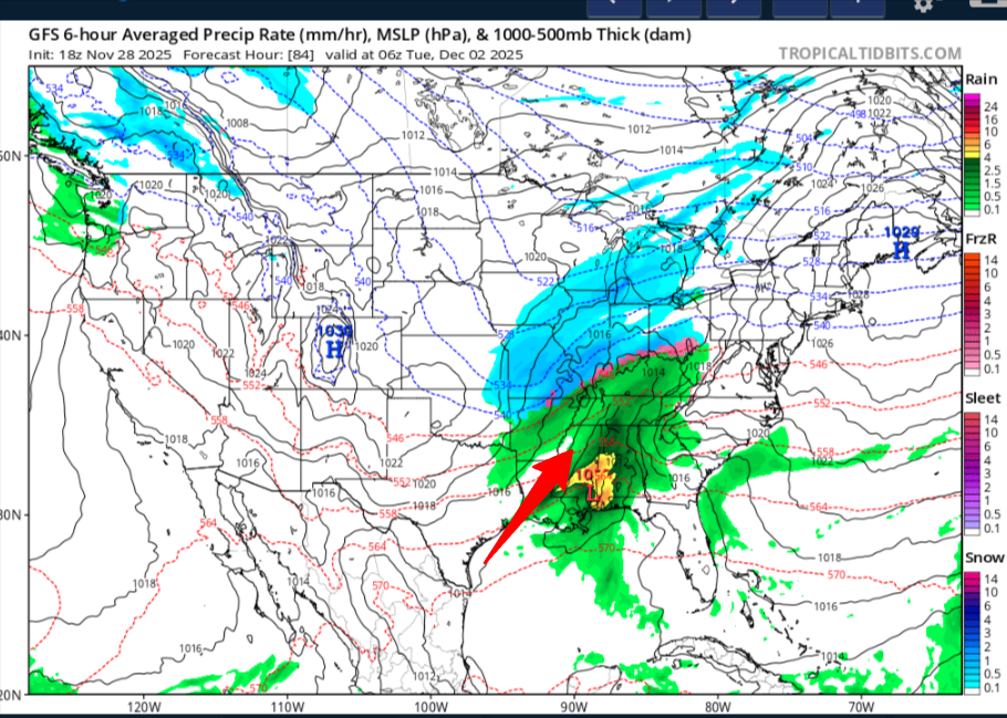
-
December 2025 Short/Medium Range Forecast Thread
jaxjagman replied to John1122's topic in Tennessee Valley
-
December 2025 Short/Medium Range Forecast Thread
jaxjagman replied to John1122's topic in Tennessee Valley
The MJO was fairly chaotic into Maritime/WP this cycle but it was into still the Maritome the first week of Nov,i need to go back and read it more thoroughly for myself,thanks for sharing this,John
-
December 2025 Short/Medium Range Forecast Thread
jaxjagman replied to John1122's topic in Tennessee Valley
Check it out this winter if the MJO gets back to P5,ill look for an archive but i doubt its the same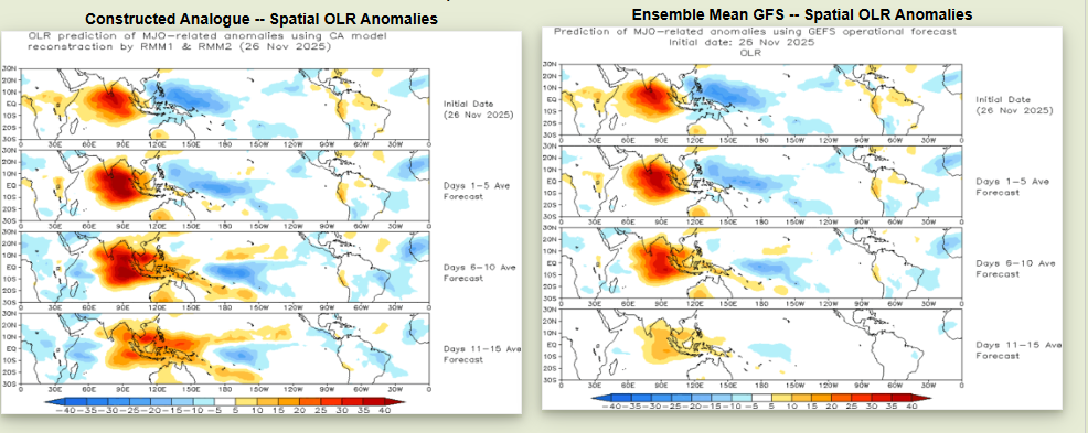
-
December 2025 Short/Medium Range Forecast Thread
jaxjagman replied to John1122's topic in Tennessee Valley
Probably need to see where the OLR is when it gets into MJO P5,right now we are in P6 with typhoon Koda
-
More members are jumping in each day around Christmas into early Jan
-
December 2025 Short/Medium Range Forecast Thread
jaxjagman replied to John1122's topic in Tennessee Valley
https://x.com/i/status/1993894442328375446 Check out his winter forecast -
December 2025 Short/Medium Range Forecast Thread
jaxjagman replied to John1122's topic in Tennessee Valley
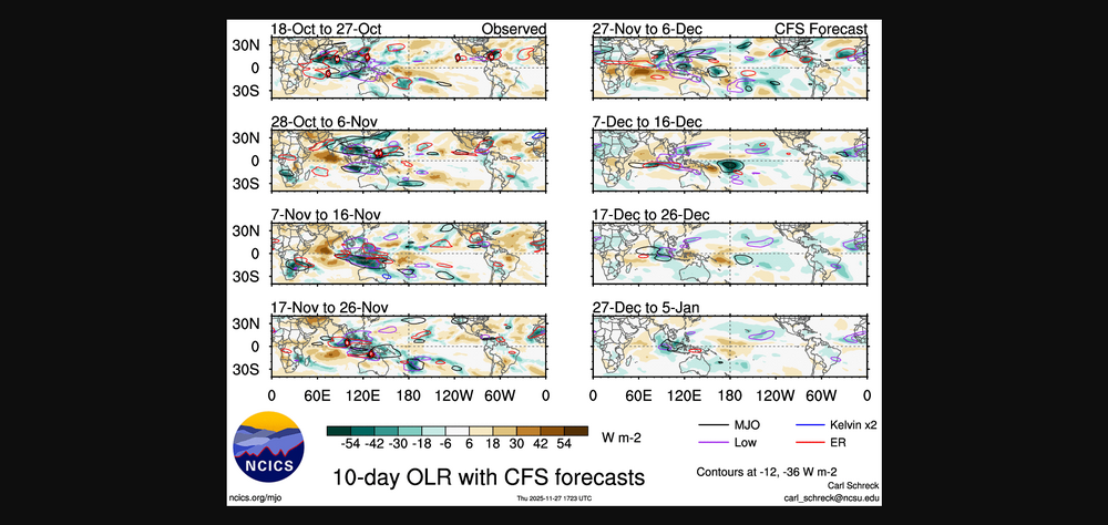
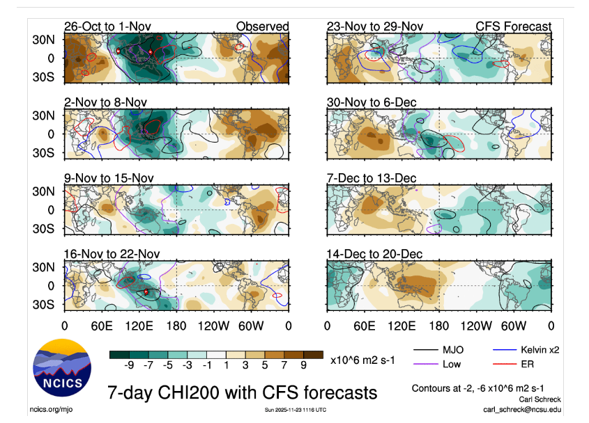
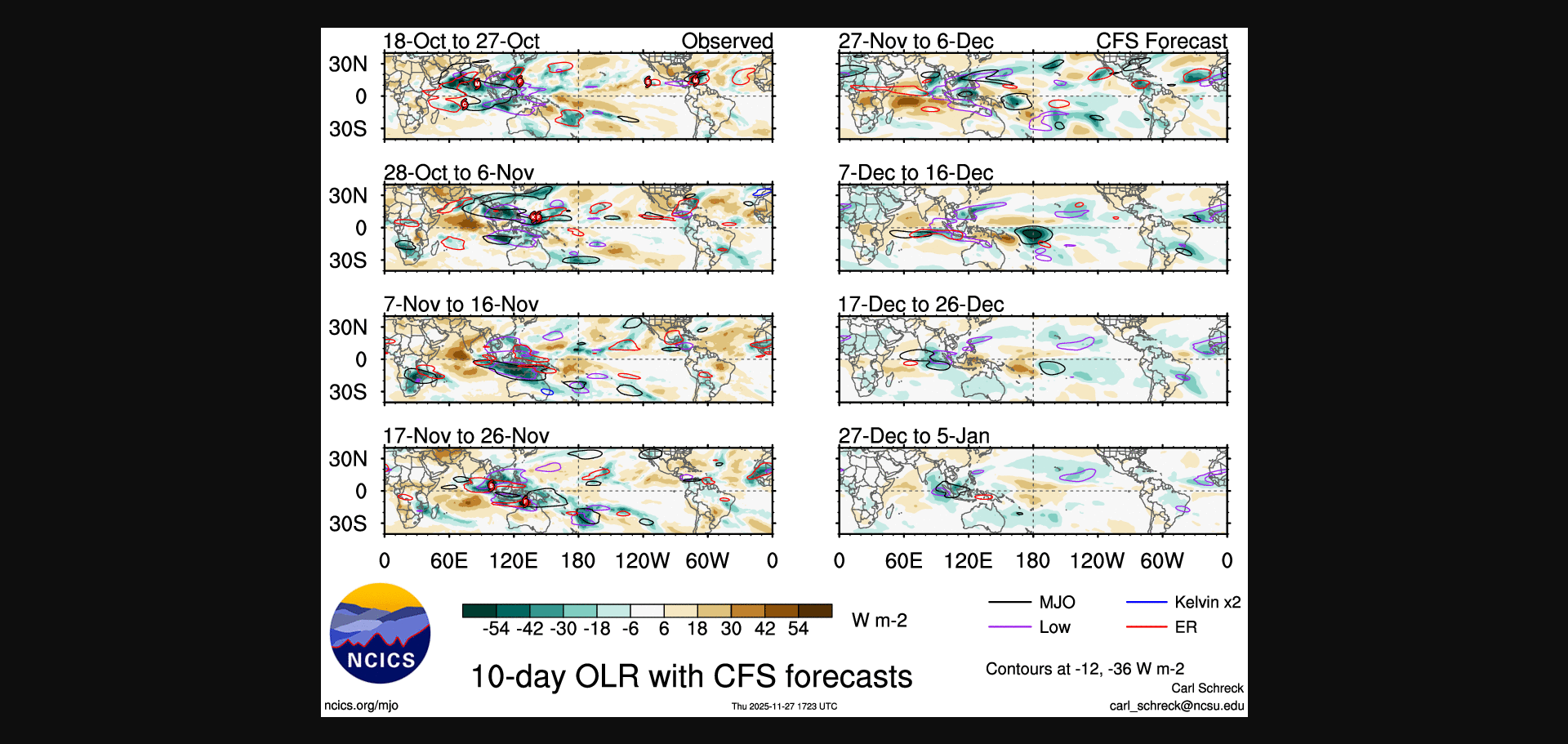
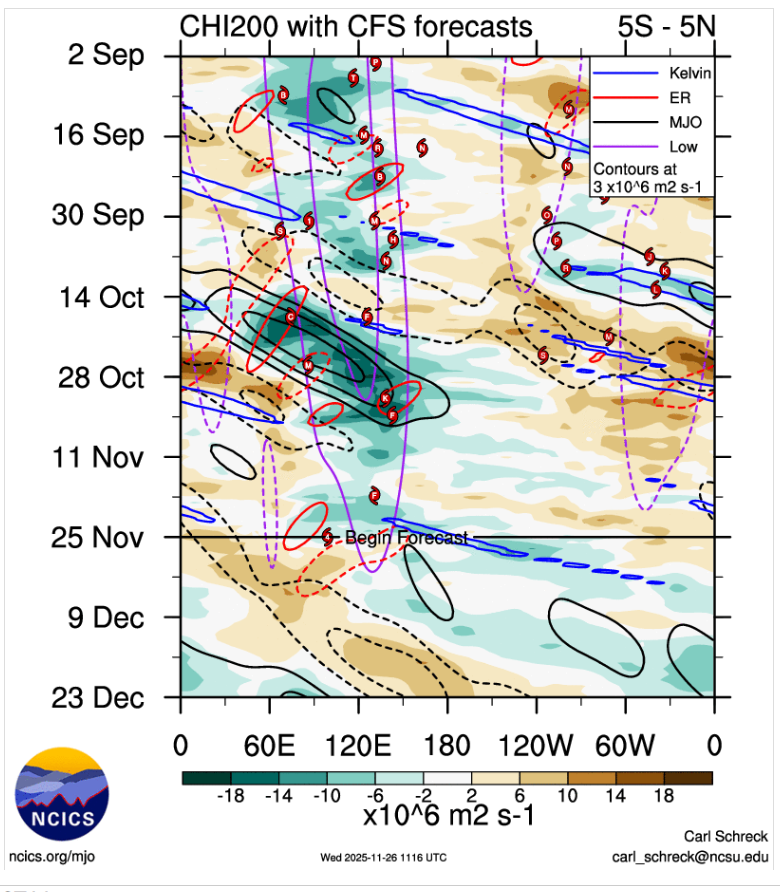
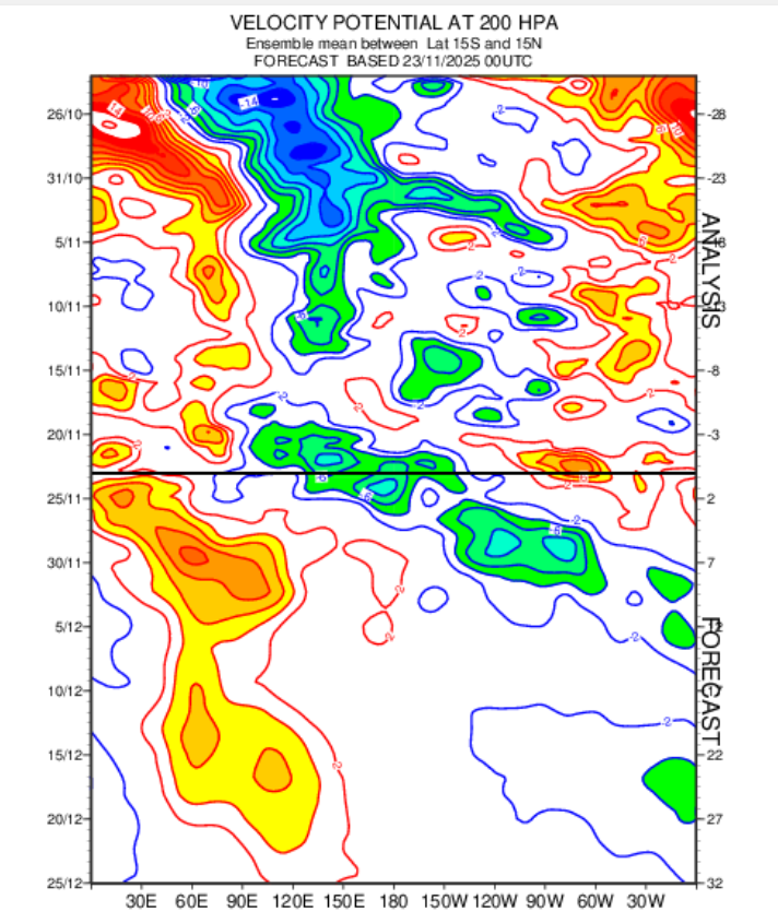
GTH Outlook Discussion Last Updated - 11/25/25 Valid - 12/03/25 - 12/16/25 Recent observations of tropical convection and the global tropical circulation indicate that the Madden-Julian Oscillation (MJO) remains active, with the enhanced convective phase over the West Pacific. Little eastward propagation was evident on the RMM-based MJO index during the past two weeks, however, fluctuations in amplitude are indicative of interference from other modes of variability. The biggest disruptor to the ongoing MJO evolution is the low-frequency La Niña base state, which is preventing upper-level easterlies, low-level westerlies, and widespread convection from crossing the equatorial central Pacific. Enhanced convection is crossing the central Pacific away from the Equator, however, especially along the South Pacific Convergence Zone (SPCZ) region. Time-longitude analyses of the low-level zonal wind field reveals two distinct features propagating eastward: a slowly evolving envelope of westerly anomalies that has progressed from the Indian Ocean in October to the far western Pacific by mid- to late November, and a faster moving signal, likely Kelvin wave activity, that is circumnavigating the globe. As this latter signal comes into phase with the slower evolving signal, westerly wind bursts have occurred, followed by a period of increasing disorganization. Dynamical model forecasts are in good agreement that a period of constructive interference between these two signals will occur in late November and early December, resulting in a disruption of the La Niña trade wind regime over the west-central Pacific, and a rapid amplification of the RMM-based MJO index in Phase-7. Beyond this period, the faster moving mode becomes more unpredictable and may not well capture an easterly phase of the Kelvin wave, but the slower-evolving low-level westerlies are favored to continue impacting the Pacific basin into mid-December. A potential second enhancement of the MJO signal is clearly depicted in both the GEFS and ECMWF model systems during late December over the East Pacific, likely tied to another period of constructive interference between the slowly propagating signal and the Kelvin wave activity. Based on this guidance, the MJO is favored to remain active, and may become the dominant contributor to the global tropical convective pattern during early December. Pacific MJO events teleconnect well with the midlatitude circulation during the Boreal winter season, and may contribute to a reinforcement of ridging across western North America and troughing over eastern North America. https://www.cpc.ncep.noaa.gov/products/precip/CWlink/ghaz/index.php -
December 2025 Short/Medium Range Forecast Thread
jaxjagman replied to John1122's topic in Tennessee Valley
Believe the GFS and Euro are killing the MJO off to fast in the WP mainly because of a Kelvin Wave is causing destructive interference.MJO is more than likely still active and moving

-
December 2025 Short/Medium Range Forecast Thread
jaxjagman replied to John1122's topic in Tennessee Valley
SOI has been fairly chaotic as of late,ups and downs,the last couple weeks,big drop two days ago,ensembles were looking severe last weekend into the first part of Dec,not no more 25 Nov 2025 1009.58 1005.50 7.63 16.34 9.25 24 Nov 2025 1007.56 1004.90 -1.40 17.10 9.38 23 Nov 2025 1009.73 1000.85 38.17 17.97 9.60 22 Nov 2025 1011.59 1003.75 31.56 17.51 9.41 21 Nov 2025 1011.94 1004.90 26.47 17.04 9.28 20 Nov 2025 1013.02 1005.20 31.43 16.68 9.16 19 Nov 2025 1013.90 1005.00 38.30 16.14 8.87 18 Nov 2025 1013.91 1006.65 27.87 15.23 8.46 17 Nov 2025 1013.24 1007.30 19.47 14.55 8.06 16 Nov 2025 1013.02 1008.85 8.20 14.05 7.64 15 Nov 2025 1011.89 1008.00 6.42 13.81 7.50 14 Nov 2025 1011.80 1008.10 5.21 13.71 7.48 13 Nov 2025 1011.52 1009.15 -3.25 13.44 7.37 12 Nov 2025 1012.06 1010.30 -7.13 13.43 7.36 11 Nov 2025 1012.19 1009.60 -1.85 13.91 7.44 10 Nov 2025 1012.05 1008.55 3.94 14.24 7.51 9 Nov 2025 1013.18 1009.05 7.95 14.46 7.52 8 Nov 2025 1015.00 1009.15 18.89 14.82 7.31 7 Nov 2025 1015.88 1008.40 29.26 14.92 6.94 6 Nov 2025 1015.28 1008.05 27.67 14.37 6.61 -
December 2025 Short/Medium Range Forecast Thread
jaxjagman replied to John1122's topic in Tennessee Valley
Still look like its getting into Africa before Christmas
.png.bc299553c890ff9901eb6530194a8570.png)
-
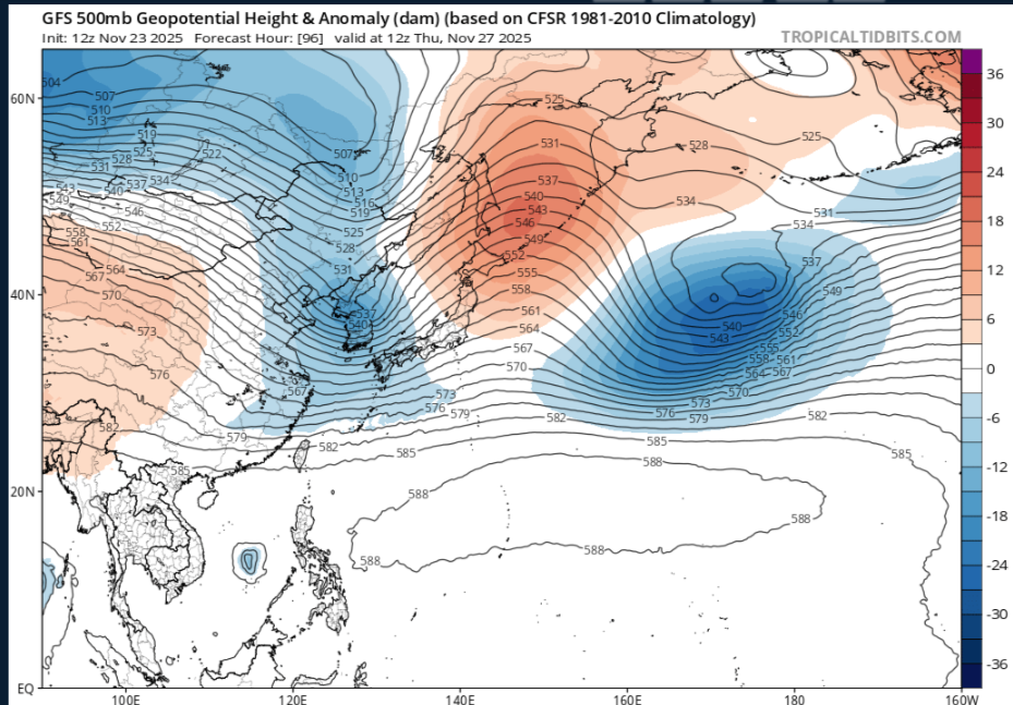
Probably and seemingly our best chance of severe should,maybe occur during the first part of Met winter.EPS and GEFS both show a Mid level Ridge building into Florida into the GOM, with a trough coming out of Eastt Asia the next couple days,this wouldnt have no problem tapping into the GOM
-
December 2025 Short/Medium Range Forecast Thread
jaxjagman replied to John1122's topic in Tennessee Valley
If you ask me this pattern we are fixing to get looks more severe in early Dec,You got heights rising before t-giving into the Sea of Okhotsk,with a trough in East Asia and rising heights into Mongolia -
December 2025 Short/Medium Range Forecast Thread
jaxjagman replied to John1122's topic in Tennessee Valley
East Asia gives you some insight of the pattern ahead,yes its never gonna be right because we have different teleconnections,sorta speaking.But honesltly 1,E,you see a ridge building into Mongolia into maybe even Russia,nothing but a trough in a few days as we head towards T-GIVING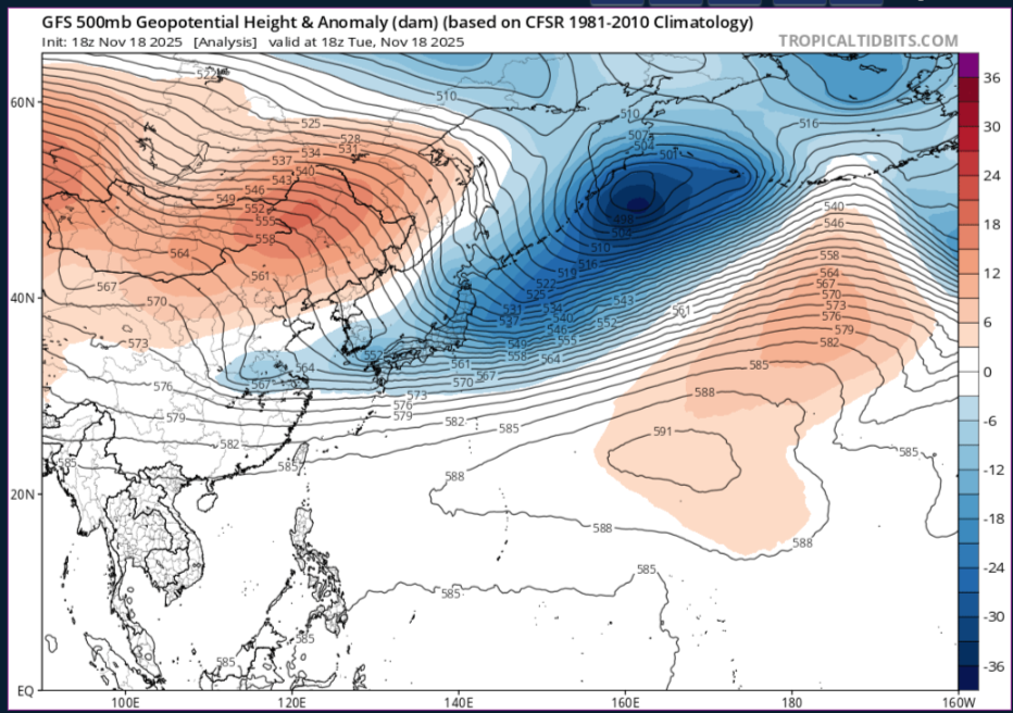
-
December 2025 Short/Medium Range Forecast Thread
jaxjagman replied to John1122's topic in Tennessee Valley
In case you dont have this you can look at Planetary and Equatorial Waves using the Euro Modes,ill shut up now -
December 2025 Short/Medium Range Forecast Thread
jaxjagman replied to John1122's topic in Tennessee Valley
GEFS looks more Euro now with any SSW,you can see it here -
December 2025 Short/Medium Range Forecast Thread
jaxjagman replied to John1122's topic in Tennessee Valley
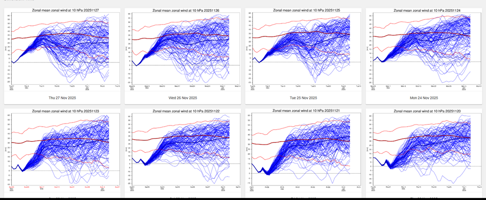
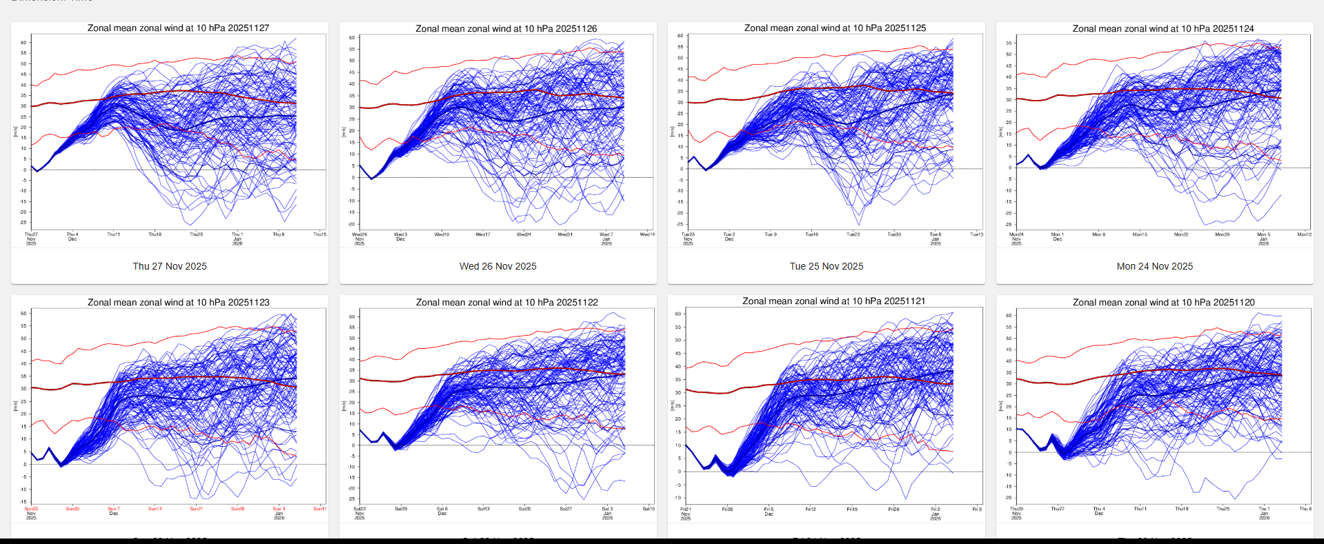
Id agree with what Jeff said up above .We seem to be seeing the the SSW underway with the sharp rise in temps into the stratosphere but even so ,the cold seems to be getting pushed back seemingly each day.The JMA right now shows a strong MJO signal in the WP into the first of Dec,while this isnt bad it still should have reflection to more or less a SER,just transient cold shots.Might not be a bad thing if you want a cold Christmas or even possibly beyond that for a couple weeks anyways.png.8ab108ae7e0dd138d17f3b7be0b7e030.png)
-
December 2025 Short/Medium Range Forecast Thread
jaxjagman replied to John1122's topic in Tennessee Valley
Cool,he finally got this running again.thumb.png.8754ab3f849d107be4ed22622bf61488.png)
-
December 2025 Short/Medium Range Forecast Thread
jaxjagman replied to John1122's topic in Tennessee Valley
LOL Looks like the quite a few members jumped the train today...lol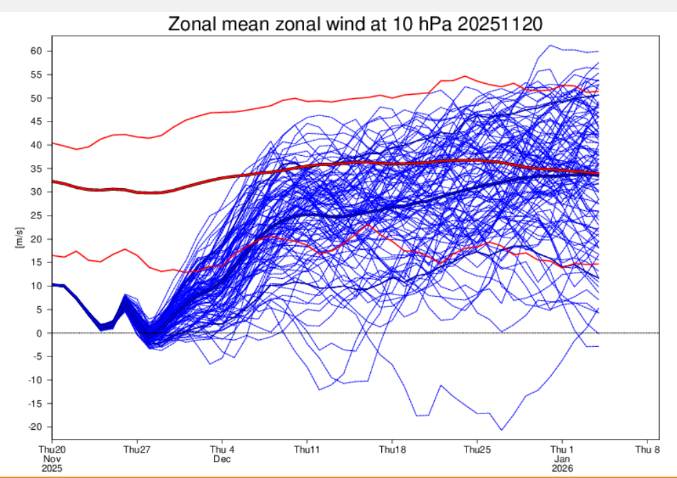
-
December 2025 Short/Medium Range Forecast Thread
jaxjagman replied to John1122's topic in Tennessee Valley
Thinking the same thing @ Carver.Like Jeff metioned a week or two ago,its gonna take a couple CF's to beat down the SER,before it can get really cold,otherwise its just gonna be transient cool down i agree also the Euro suites struggle with systems out west,more than likely today with that trough out west.GEFS dont show much change today,not perfect but not as extreme as the EPS


.png.363184d55bca212eb42bb968f3f78e60.png)
