jaxjagman
-
Posts
8,627 -
Joined
-
Last visited
Content Type
Profiles
Blogs
Forums
American Weather
Media Demo
Store
Gallery
Everything posted by jaxjagman
-
Seemingly what the Euro is showing today is the PV is headed towards the Baffin Sea but it still looks like a brick but either way,no reason to nicpick right now,see what it shows in a couple days or so,ill move this into winter thread,no need to keep it into Dec

-
That would be everyones dream into the meat of winter
-
He's been making some good vids as of late compared to some of his in the past. Right now the SPV the last few days has been just displaced and tilted.But there is as least some some signs by the Euro it could change in upcoming days.But right now its fairly like a rock.Going into 2014 the SPV was weak and let cold air pour into NA 2014 i think it was Daniel and i was talking about that year several days ago with the record proportion +TNH and +EA in 2014,excuse me if i got that poster wrong,i'm to lazy to go back and look. But that winter in Jan., 2014 it got extremely cold into even parts of Ky dropping down into the -30s. But 2013-2014 winter does have some similarity going for it compared to this winter.Even if you look at the ONI both these winters into S-O-N were both -0.2,if we we get a repeat of 2014,who knows ATM,we know how things can change in our parts
-
Actually, its not a horrible look as we get in Jan,if it were to hold
-
Yeah its snowing now
-
Some flurries here now,unless that is bugsI went outside just now and saw nothing https://g1.ipcamlive.com/player/player.php?alias=brentwood201173a
-
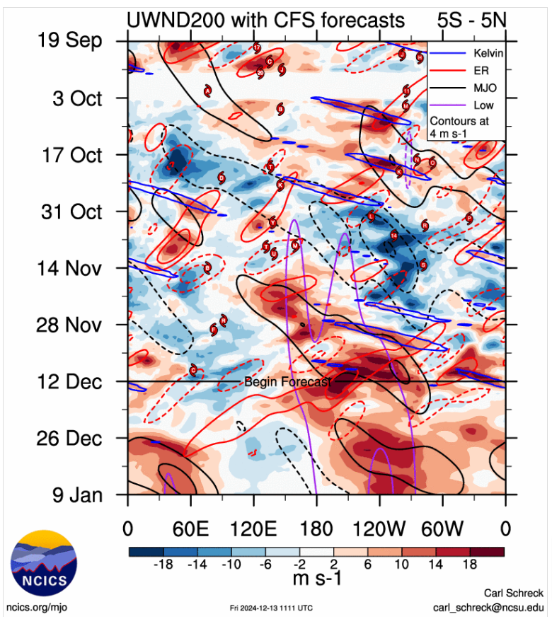
Yeah,it still bothersome to get the PNA broke down or the cold is going to our west But there is more spread today with the Euro ensembles,this could be also from a KW moving around the IDL right now could be causing destructive interference with the MJO signal,dunno
-
I was hoping for a cold Christmas but the good PNA is getting broke down in which the long range models are showing and the GWO is showing signs going back to negative,if this was severe season i'd be getting excited,also the stout SPV via the Euro is getting displaced towards Greenland ,you dont want to see this,i was wishing for a cold Christmas but each day that passes it get more and more depressing,
-
But the Euro is showing this breaking down into the 2nd week of Dec,right now anyways
-
Yeah i believe that was the year we had a Winter Weather Warning here in the 2013-14 for that storm but i believe we got warm nosed in our parts it ended up being just liquid rain,thats when the snow dome started.
-
When discussing "TNH index" with "La Niña,"it refers to the potential impact of a La Niña event on the Tropical Northern Hemisphere (TNH) weather pattern, which is a climate index that describes large-scale atmospheric pressure variations across the North Pacific and North Atlantic, often leading to specific weather patterns across North America, especially during winter months; During a La Niña phase, the TNH pattern can be amplified, potentially causing colder and wetter conditions in certain regions depending on the specific atmospheric conditions. Key points to understand: TNH Index: This index measures the strength of the TNH pattern, which is characterized by high pressure over the Gulf of Alaska and low pressure over the eastern North Atlantic. The Girl: A climate phenomenon where the central and eastern equatorial Pacific Ocean experiences cooler than average sea surface temperatures, impacting global weather patterns. Connection: During a La Niña event, the jet stream can become wavy, sometimes enhancing the TNH pattern, which can lead to colder temperatures and increased precipitation in certain parts of North America. How to interpret: Positive TNH with La Niña: A strong positive TNH index during a La Niña phase could indicate a higher chance of colder and wetter winter conditions in parts of the United States. Negative TNH with La Niña: A weaker or negative TNH index during a La Niña might lead to less pronounced weather impacts related to the TNH pattern.
-
Here it is Daniel https://en.wikipedia.org/wiki/2013–14_North_American_winter
-
I'm not sure,might be a Jeff question.If i'm not mistaken the 2013-2014 winter that was the year the TNH was positive,the 2nd highest on record that was when Atlanta got crippled by a winter storm and that was the winter the snow dome came out for Nashville.Met might know if that was the year but i'm pretty sure it was for the Atlanta storm
-
Seemingly right now its typical Nina,cold into the early season then crap as we get into towards the holidays.Even the CFS,JMA shows something similar.Maybe it will change,but it definite needs to get out of there
-

Fall/Winter Banter - Football, Basketball, Snowball?
jaxjagman replied to John1122's topic in Tennessee Valley
Auburn basketball has had a brutal schedule so far.Houston,Iowa St, tonight NC and next week Duke,dont think anyone else has had such a brutal schedule,its like playing in the Big Dance before conference play..lol -
Storm surge alone is gonna be brutal once again into Tampa Bay seemingly right now,they surely don't need to get hit again right now
-
We went to my wifes dads house in St Pete this week to just help clean things up and move what we could salvage and move it into storage inland,he has Parkinsons disease and cant do to much on his own,his house was under 4-feet of water,thats someones boat in his swimming pool,its still there no one has claimed it as of yet

-
Summer-Fall 2024 Weather Disco Med/Long Range
jaxjagman replied to John1122's topic in Tennessee Valley
This is my wifes,dads house in St Pete,they just refurbished the swimming pool this year and its ruined now.it also has a boat in the pool,we dont know whos boat it is yet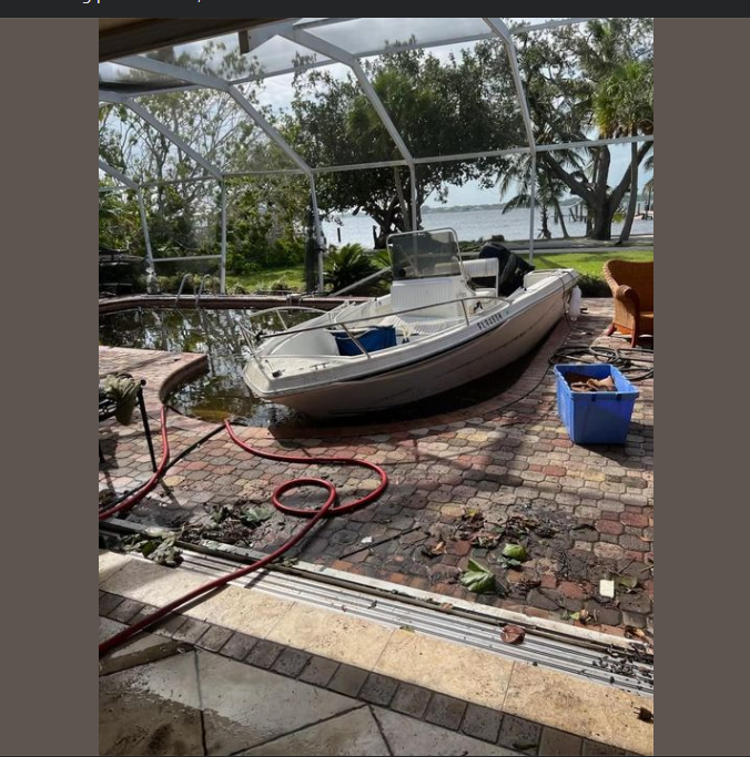
- 689 replies
-
- 2
-

-
- heat
- thunderstorms
- (and 7 more)
-
Summer-Fall 2024 Weather Disco Med/Long Range
jaxjagman replied to John1122's topic in Tennessee Valley
It was brutal for you in the east of us,wish we'd have started a thread for it,its definite a historic event ,especially you guys east uf us- 689 replies
-
- 2
-

-
- heat
- thunderstorms
- (and 7 more)
-
Summer-Fall 2024 Weather Disco Med/Long Range
jaxjagman replied to John1122's topic in Tennessee Valley
We had a unique set up last storm with the ULL and the ridge to the east,might not see that ever again in our life time- 689 replies
-
- 2
-
-
- heat
- thunderstorms
- (and 7 more)
-
Summer-Fall 2024 Weather Disco Med/Long Range
jaxjagman replied to John1122's topic in Tennessee Valley
I dont see this is possible myself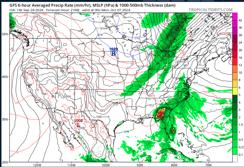
- 689 replies
-
- 2
-
-
- heat
- thunderstorms
- (and 7 more)
-
Summer-Fall 2024 Weather Disco Med/Long Range
jaxjagman replied to John1122's topic in Tennessee Valley
Models keep showing tropical genesis in the GOM in the extended time frame,my thinking is the models are to fast ATM with this trough which should steer the potential TC,guess we'll see but i think this trough the models are showing is to fast,this should have some steering mechanics where the cyclone does go
- 689 replies
-
- 2
-
-

-
- heat
- thunderstorms
- (and 7 more)
-
Summer-Fall 2024 Weather Disco Med/Long Range
jaxjagman replied to John1122's topic in Tennessee Valley
Would be wild to feel the effects of three tropical systems here in one season,we rarely feel much effect here from one when ever 2. Western Caribbean Sea and Gulf of Mexico: An area of low pressure could form over the western Caribbean Sea in a few days. Environmental conditions are expected to be conducive for additional development thereafter while the system moves generally northwestward, and a tropical depression could form during the middle to latter part of next week as the system enters the Gulf of Mexico. * Formation chance through 48 hours...low...near 0 percent. * Formation chance through 7 days...medium...40 percent.- 689 replies
-
- 4
-
-
-
- heat
- thunderstorms
- (and 7 more)
-
Summer-Fall 2024 Weather Disco Med/Long Range
jaxjagman replied to John1122's topic in Tennessee Valley
We 've had around 3-4" here so far,should possibly get a couple more,its definite gonna be a drought buster for us which i'm happy about- 689 replies
-
- 3
-
-
- heat
- thunderstorms
- (and 7 more)