jaxjagman
-
Posts
8,684 -
Joined
-
Last visited
Content Type
Profiles
Blogs
Forums
American Weather
Media Demo
Store
Gallery
Everything posted by jaxjagman
-
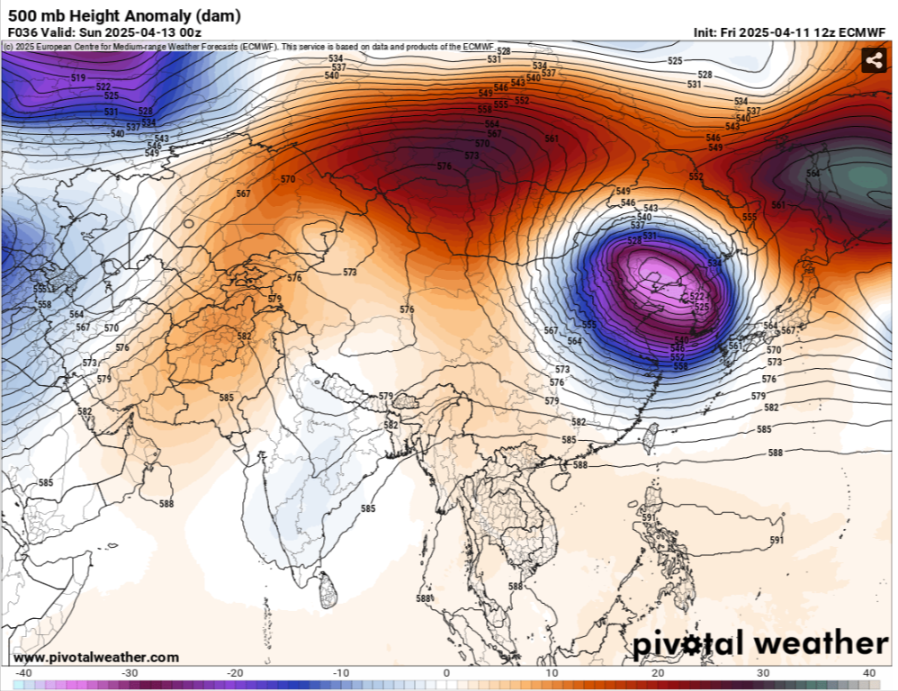
Might be a day or two later but thats not a weak Upper Level Low going through East Asia the next day or two.With heights rising into Mongolia and Japan,i'd be surprised myself if the models dont start showing a more severe threat in the upcoming runs

-
Think we should have a decent chance of severe as we get around the 20-21 of April.Thats a strong ULL coming into from East China into the Koreas next weekend,all the models are showing this with rising heights into Mongolia and Japan,looks kinda meh until then,dont mean you cant get severe just looks meh
-
We had a tornado contest years ago here,I'd always pick Yazoo City in those parts when in storm mode,that town is a tornado magnet..lol
-
-
Be watching Auburn so im staying home.Some of the latest Mesoscales look better south of Memphis about 50-75 miles give or take,thats around mid afternoon,it dont look bad even where you are at later
-
I went to bed about 11AM Wed night before the storms here came trough and it was still 81.Today here we made it to 87 high,Nashville OBS says it was 86 so it missed the record of 87 in 1934
-
Big HAIL
-
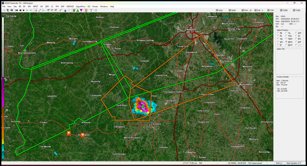
NROT IS UP TO 2 now that cell headed towards Thompsons Station
-
That sure look like a tornado to me..lol
-
Centerville is showing rotation also now
-
Finally seeing rotation now
-
Big hail from Holenwald cell ,marker has 4.29"
-
Tor emergency now
-
over Lake City now
-
2,5 now on NROT
-
Looks like a large tor over Bay ,Ark,NROT is showing a 2.0 and its a confirmed cell
-
URGENT - IMMEDIATE BROADCAST REQUESTED Tornado Watch Number 98 NWS Storm Prediction Center Norman OK 250 PM CDT Wed Apr 2 2025 The NWS Storm Prediction Center has issued a * Tornado Watch for portions of Eastern and South-Central Arkansas Southern Illinois Southwest Indiana Western Kentucky Southeast Missouri Northern Mississippi Western Tennessee * Effective this Wednesday afternoon from 250 PM until Midnight CDT. ...THIS IS A PARTICULARLY DANGEROUS SITUATION... * Primary threats include... Several tornadoes and a few intense tornadoes likely Widespread damaging winds and isolated significant gusts to 80 mph likely Scattered large hail and isolated very large hail events to 2 inches in diameter possible SUMMARY...Storms are expected to develop this afternoon initially across the ArkLaMiss and Mid-South, with the overall environment becoming increasingly favorable for tornadoes through late afternoon into early/mid-evening. Some of these tornadoes may be strong or intense (EF3+), with widespread damaging winds also likely across the region by evening. This is a Particularly Dangerous Situation with intense storms expected over a relatively broad regional area, with multiple rounds of severe storms possible in some areas. The tornado watch area is approximately along and 90 statute miles east and west of a line from 55 miles southeast of Pine Bluff AR to 30 miles northwest of Evansville IN. For a complete depiction of the watch see the associated watch outline update (WOUS64 KWNS WOU8).
-
Stuck in town.Wife is working out of town tomorrow and her mom has a doc appt, i have to take her
-
US National Weather Service Nashville Tennessee *** 5:29 p.m. update: We have also confirmed an EF-1 tornado (95 mph winds) touched down in McEwen/Humphreys County (150 yards wide/1.7 miles long). We may be surveying additional damage sites tomorrow. *** We have so far confirmed 3 tornadoes in Middle Tennessee resulting from last night's storms. This is preliminary information, but we can tell you that an EF-2 tornado (120 mph winds) touched down in Hampshire/Maury County (400 yards wide, 5.1 miles long). An EF-1 tornado (100 mph winds) touched down in Mt. Pleasant/Maury County (300 yards wide, 4.1 miles long). And an EF-0 tornado (85 mph winds) touched down in Fairview along the Hickman/Williamson County line (150 yards wide, 2.2 miles long). We are currently surveying one more damage site, so there may be a 4th confirmed tornado.
-
A tor warned cell here,no tor, hail,wind and one of the best light shows ive seen in years
-
Tornado hit McEwen,damage reports coming in
-
Hopefully Auburn plays like they did into the 2nd half against Michigan,that first half was brutal trying to be cute with the b-ball,so many turnovers.Staying home drinking beer and watching Auburn and probably yelling at my TV and listening to my wife saying hush
-
Biggest threat still looks to be to our west,but yeah we could get some healthy rains
-
-
Cutting jobs at the NWS,its really sad how bad these models will become than they already are.I really think hes hoping for a weather disaster and he will come out and say"This is why we need AI technology" and blame the NWS.I know we arent suppose to talk politics and i wont say no more.I cant imagine what emotions you guys as mets are going through right now,i'm sure it's not good and healthy.But i'm really glad to have you mets posting here,its like going to school once again i learn for you guys.So thanks !!