jaxjagman
-
Posts
9,119 -
Joined
-
Last visited
About jaxjagman

Recent Profile Visitors
11,235 profile views
.thumb.jpg.049f4a7f726ada07e8cd30bd17e713cb.jpg)


-

2026-2027 Strong/Super El Nino
jaxjagman replied to Stormchaserchuck1's topic in Weather Forecasting and Discussion
Has there ever been a ENSO maybe comparable to this on other than maybe 2009?Even this WWB upcoming is seemingly going to combatted more or less with a EWB -
Dont see much of any severe the next several days just some possible thunder,guess its that time to go hibernate back into seasonal threads..lol
-
2026-2027 Strong/Super El Nino
jaxjagman replied to Stormchaserchuck1's topic in Weather Forecasting and Discussion
-
Maybe we will see thunderstorms anyways in the upcoming days,seems like we fixing to see a ERW along with maybe a CCKW,in which the Rossby wave will kick off the strong WWB EAST of the IDL, This would kick off a more monsoonal flow and put us in a wet unstable pattern in a few days more or less.Least we should see some much needed rains here
-
I think that was the cell i was watching on my radar yesterday
-
Allergies have been kicking my butt the past couple days,i havent paid much attention to anything weather related the past couple days,so glad we got some rain and knocked the pollen down
-
Looks close to where we are at, we are off Carothers
-
We was moving yesterday,moving from Brentwood to Franklin Tn i assume this was yesterday?It wasnt here..lol
-
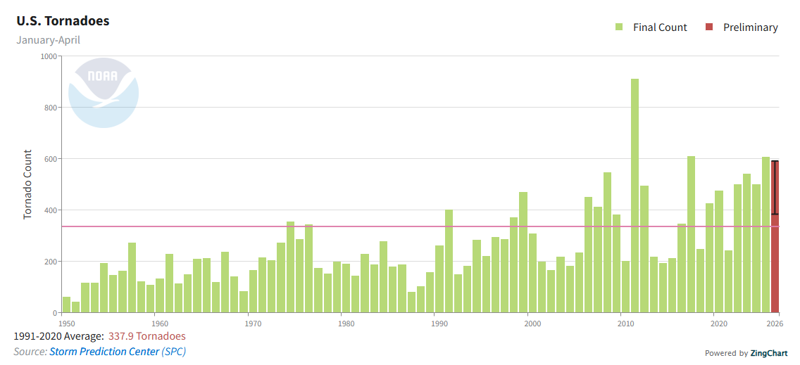
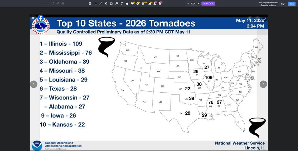
Thought we might see the Middle of the month get more active into our parts,that seems to be slip sliding away,like the old Paul Simon song would say. Its not like its not been a active year so far.Still seems kinda weird how Wisconsin has had as many tornadoes this year as Alabama and yet Illinois and Miss has give or take almost 40% of all tornadoes this year so far.Oh well,its called weather, right?

-
2026-2027 Strong/Super El Nino
jaxjagman replied to Stormchaserchuck1's topic in Weather Forecasting and Discussion
These westerlies the models have been showing has been countered with strong easterlies,so they have failed to get much past the IDL,maybe its gonna be different this time,probably could be the strongest ERW east of the IDL yet in this event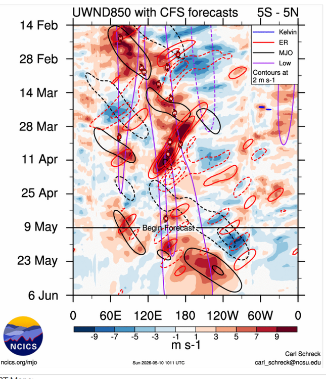
-
2026-2027 Strong/Super El Nino
jaxjagman replied to Stormchaserchuck1's topic in Weather Forecasting and Discussion
Still seems kinda strange why you dont see the AAM and SOI synced up.Im not saying this wont be a strong NINO,even CPC today shows some pockets today of +8 down into the subsurface.The next WWB seems to be caused by a ERW into the eastern PAC,whicH we havent seen these strong WWB so far -
2026-2027 Strong/Super El Nino
jaxjagman replied to Stormchaserchuck1's topic in Weather Forecasting and Discussion
We seem to headed towards a WQBO into summer,while the AAM and even SOI is still not coupled quite well,they both look NINA and not NINO ATM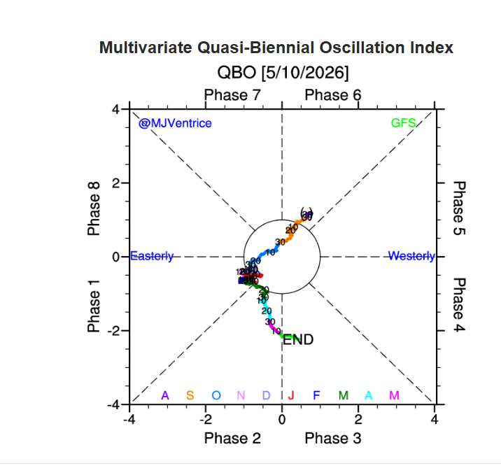
-
2026-2027 Strong/Super El Nino
jaxjagman replied to Stormchaserchuck1's topic in Weather Forecasting and Discussion
-
2026-2027 Strong/Super El Nino
jaxjagman replied to Stormchaserchuck1's topic in Weather Forecasting and Discussion
Typically you see the Atmospheric River get going in a strong NINO on the west coast,so you dont see these SST'S out west.Like the NMME'S shows,Its the same into the GOM more or less downstream Out into the Yellow Sea and Sea of Japan has alot has to do with The Siberian blocking,so there's no guarantee even that that region will be warm or cold in a strong NINO. https://svs.gsfc.nasa.gov/4416
-
Did you go 55?I was watching my radar last night of the PDS,that had to be at least a EF3,i was kinda busy and couldnt watch the whole show but that was a nice couplet as it was headed towards Bube in that vicinity