

dendrite
-
Posts
75,095 -
Joined
Content Type
Profiles
Blogs
Forums
American Weather
Media Demo
Store
Gallery
Everything posted by dendrite
-
NAMAI is over the accordion
-
I still think it helps more than hurts.
-
Yeah…follow it right down here
-
The CCB is not getting back to ALB. Probably not even the deformation.
-
I’ll take that back. Looks better for AEMATT
-
Yeah not much change in the op
-
A slight SE tick with the ec AIFS
-
GFS is a little west of other guidance right now with pivoting that vortmax around the ULL in the OH valley area. It let’s it curl up closer to the Cape.
-
Lousy wave spacing there.
-
84hr nam…take a shot
-
I remember the 1 euro run for a day and we didn’t have QPF
-
Some flags MHT south for me…dry air aloft and sim radar has that shredded look quickly after 00z. Wonder if it goes from steady snow to heavy showery junky frozen precip after a couple hours.
-
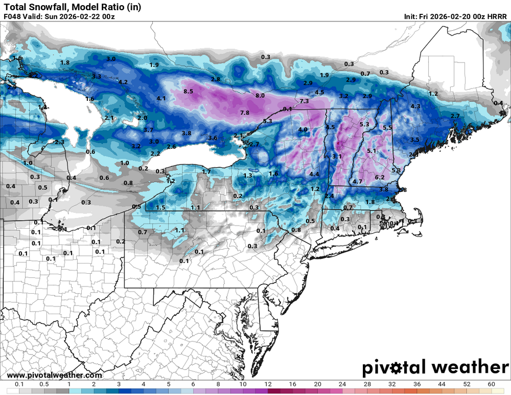
HRRR doing HRRR things…-80 dews aloft Trying to spit sleet into S NH with a snow column Modeled snowfall
-
That’s the JMA claim to fame. Not sure the KMA has ever had its 15 minutes yet.
-
This is the HECS thread
-
Better chance they find a cane than an inch of snow for you.
-
Can’t believe they were able to tie it with the goalie pulled.
-
9-10:1 on the WAA and then fluff on Saturday. Similar deal to the roided SWFE in Jan. Although toss the 30-40:1 ratios yielding another 6+. But yeah, maybe we average out 11-12:1.
-
Pretty juiced up run for NH on the 3k
-
Yeah we need larger scale changes.
-
I like how every event supposedly has an inv trough now.
-
That’s a borderline of a warning. I guess they changed it to 6”+ for an event versus the old 12/24hr criteria. But yeah, we’ll need a little boost in ratios Saturday I think to get the county averages over 6”
-

-
Clock is ticking, but there’s still 6 weeks of snow threats up here. The driveway is opening up finally though. The last 2 days have been nicer than the Jan warmup at least up here. Full sun and 40+.
-
N Foster is 62” Not sure how he compares


