dendrite
-
Posts
75,095 -
Joined
Content Type
Profiles
Blogs
Forums
American Weather
Media Demo
Store
Gallery
Everything posted by dendrite
-
Toss Nate Silver further than the NAM
-
Maybe Killington will try to secede from Vermont again?
-
Strange because my forsythia are blooming.
-
Buds are beginning to swell.
-
I never really thought of the OCD aspect, but now that you mention it I agree with that too.
-
Am I the only one who likes the heated walkways? I'd love a heated driveway.
-
It was 32-33° during the squall and the road has some trapped heat so I think it melted shortly after falling. Then it cleared and dropped to 30° so it was a good recipe for sheet black ice. The squalls came through around 4am so there was plenty of time to salt...just poor judgment on NHDOT’s part.
-
The nice thing about them is they whiten you back up after cutters and torches.
-
So dumb.
-
Yeah you're getting blitzed right now.
-
Tweeting is cheaper than salting I guess.
-
Please wear your seat belt.
-
NHDOT can **** off. Scariest drive of my life and on Election Day morning. I93 from Sanbornton to Canterbury was a war zone. It looks like an ice storm in Atlanta. We were going 10mph in spots and you still couldn't stop yourself from sliding. Not one ****ing ounce of salt on the highway either. I finally got to work, but I'm still shaking. JFC
-
Just woke up to heavy snow. 32°
-
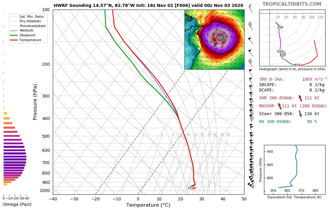
Gotta love point-click forecast soundings.

-
Yeah...that was a good early season one in CON. Looked like Allenstown/Candia was getting the brunt of it.
-
Getting a -SHSN in CON. The wind is ripping.
-
I was at TJ Maxx in Gilf with Lisa today and saw norway samaras littered on the sidewalk. I have no idea where the trees are, but know the ones in the parking lot are japanese lilacs. If I find them I may set them ablaze.
-
Still another hit to Stein. He may have to cut his grass again by next Wednesday.
-
Ah shit. I know better than that too.
-
The oaks here took quite a hit after the cold Saturday morning. It was like 1/4SM vis.
-
Stein!
-
-
We get Alaskan Thanksgivings but we get Key West Christmases.
-
I'm hoping for a sunny torch on Thanksgiving so we can all eat outdoors.