dendrite
-
Posts
75,095 -
Joined
Content Type
Profiles
Blogs
Forums
American Weather
Media Demo
Store
Gallery
Everything posted by dendrite
-
34.8° BKN...had some flurries earlier. Pretty breezy morning. Looks like some of the valley locations in SW NH decoupled and fell into the low 20s. Otherwise we were very mixed and around freezing all night.
-
A little hyperbole here. I just liked the original Goofus idea of a warm Thanksgiving with windows open or even eating outside. No need to read into it more than that.
-
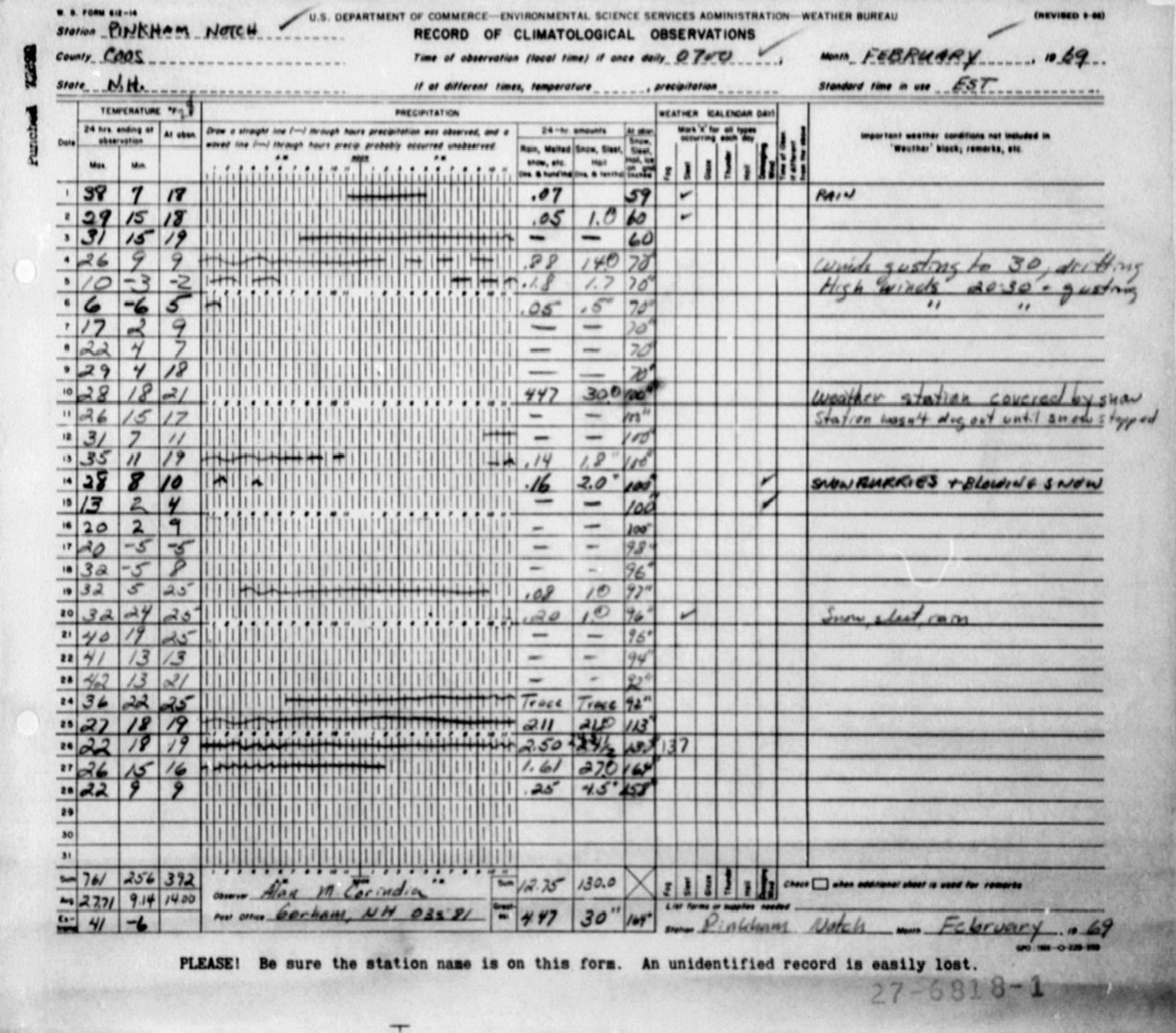
I’ve posted the Pinkham form before, but here it is again with the back story on the event. Had to go to archive.org to find the story again since the url is now dead. https://web.archive.org/web/20160817212606/https://www.ohcroo.com/winter_of_1969.cfm

-
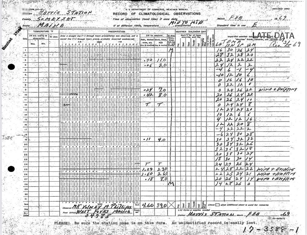
Here’s the Harris form.
-
Remove Pinkham? It’s legit and representative of the high terrain in the area.
-
Yeah if my back is better I can’t wait for 30s and drizzle. Keep those windows sealed tight and pack everyone in around the table like obstructed views at Fenway. Then just let everyone breathe on each other’s food. Can’t wait.
-
GFS is wedged now too. From 60° to 30s in a few days for Thanksgiving.
-
Stuck in the 40° RA BR here too although PSM broke free.

-
I think I damaged a vertebrae in my mid/upper back years ago and every once in awhile now I think I pinch nerves. The pain goes into my right lat. it’s either the nerves or I tore something near where the lat attaches near the spine and I keep aggravating it. El sucko.
-
Glad that’s mostly just to my SE. Wrecked my back again and can’t deal with a flooded run today. Bed ftl.
-
Looking good. Chippies got some of them. Steve sent me some too. We’ll see if the SNE ones handle winter better than BNA. I got these from Sheffield’s, but I had to wait a year for the notification they were in stock. https://sheffields.com/seeds/Castanea/dentata Go Native trees has started trees in stock and sometimes seeds. I got germinated ones from them in spring of 2019 and saplings in 2018. I prefer the direct from seed method with these since they have such a deep taproot. If the regulations are progressing for the resistant trees you could wait it out a few years for those as well. Generally they want you to grow a pure non-GMO tree along with one of the eventual resistant ones so that they can fertilize each other and increase genetic diversity. Guess I’ll be going for the 6ft ones then. lol
-
I’m working on the Weymouth 2015 one right now.
-
I have to protect them from the voles and chippies too. I found that out the hard way the first time I tried it. I may try some of those 4-5ft tree tubes to train them going upward because my other chestnut trees are growing as much outward as upward since they have a wide open field. I'm afraid to prune them and introduce wounds.
-
Maybe all of yours fell in my yard.
-
35/22 Very -SN
-
22.5° this morning. Cool, but nothing insane for this time of year.
-
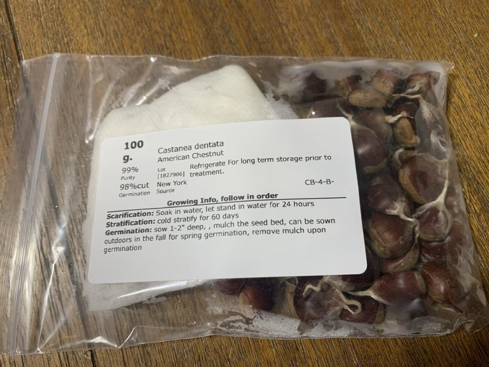
Yeah it must be the Darling named GMO trees then. I think they only had to change a few genes out of the 40k in the genome. The added gene produces oxalate oxidase (OxO) which neutralizes the oxalic acid that is produced by the blight fungus. So the fungus can actually exist on the trees without the acid being formed to kill it. And the gene is found naturally in wheat and bananas and other plants already. I think there's another marker gene in there for identifying which seeds actually have the resistant gene. So really it's like 99.999% or better. https://www.esf.edu/chestnut/about.asp Here's my seeds that came in. They are way smaller than the Chinese ones you can find in grocery stores right now.
-
Pass me the gravy and sunglasses. KMHT GFSX MOS GUIDANCE 11/21/2020 1200 UTC FHR 24 36| 48 60| 72 84| 96 108|120 132|144 156|168 180|192 SUN 22| MON 23| TUE 24| WED 25| THU 26| FRI 27| SAT 28|SUN CLIMO N/X 30 41| 38 50| 29 41| 17 43| 43 60| 35 47| 33 48| 38 26 44 TMP 31 39| 43 40| 30 31| 20 40| 46 51| 37 41| 35 41| 40 DPT 23 31| 41 30| 18 10| 14 35| 42 41| 34 36| 31 35| 34 CLD PC OV| OV OV| CL CL| PC OV| OV PC| CL PC| OV OV| OV WND 4 6| 8 14| 11 13| 5 9| 9 10| 4 6| 4 6| 6 P12 2 17| 85 96| 4 0| 5 42| 71 16| 12 28| 22 23| 22999999 P24 17| 96| 6| 42| 79| 28| 39| 999 Q12 0 0| 2 3| 0 0| 0 1| 3 0| 0 0| | Q24 0| 4| 0| 1| 4| 0| | T12 0 0| 2 4| 1 1| 0 1| 2 0| 0 0| 0 0| 0 T24 | 2 | 4 | 1 | 2 | 1 | 1 | 3 PZP 0 2| 7 3| 1 0| 8 13| 0 2| 3 5| 1 2| 2 PSN 47 46| 1 11| 54 84| 84 44| 3 4| 4 7| 9 7| 10 PRS 18 19| 3 15| 30 13| 0 9| 2 2| 3 1| 3 2| 4 TYP S S| R R| S S| S S| R R| R R| R R| R SNW 0| 0| 0| 0| 0| 0| |
-
Nice. So these are the GMO "Darling" trees from Suny-ESF? As far as I know those weren't given the government approval yet, but maybe they know more than what has been publicly released yet. If so, that's awesome news. I actually purchased a bunch of seeds online this fall and I have them stratifying in the fridge now. Come spring I'll directly plant the seeds and let them freely root their taproot on their own. If anyone is around me and wants a few let me know.
-
Off next week. Bring it.
-
26.2F Too cold
-
40.8° with flakeage.
-
I guess we don’t care one iota.
-
What’s the coldest extremes you’ve experienced?
-
Lookin good