

dendrite
-
Posts
75,095 -
Joined
Content Type
Profiles
Blogs
Forums
American Weather
Media Demo
Store
Gallery
Everything posted by dendrite
-

Active mid December with multiple event potential
dendrite replied to Typhoon Tip's topic in New England
North of the deform it'll be crap ratios...especially with dry air advecting into the low levels. Some of the models have some mid/upper level lift coming through on the tail end as the upper level system swings through so maybe we can do 1--3" of fluff in a best case scenario. I wouldn't totally rule out the deformation axis being near you either although odds favor it being more south. -
Active mid December with multiple event potential
dendrite replied to Typhoon Tip's topic in New England
Even the NAVGEM is deforming from W MA to LWM. -
Active mid December with multiple event potential
dendrite replied to Typhoon Tip's topic in New England
Looks like they're following strong convection.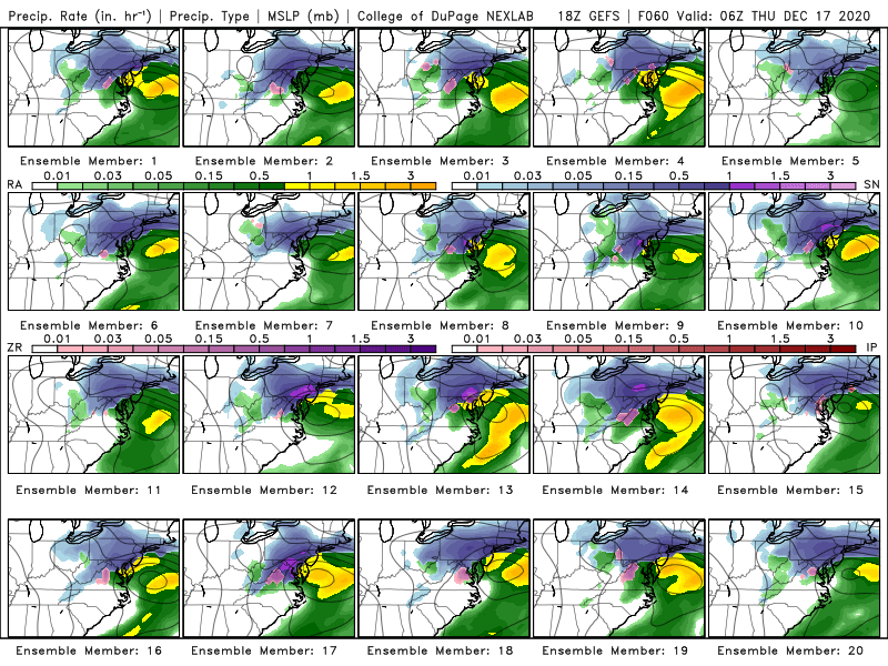
-
Active mid December with multiple event potential
dendrite replied to Typhoon Tip's topic in New England
idk...those 3 lows are all weak sauce and halfway to Bermuda. -
Active mid December with multiple event potential
dendrite replied to Typhoon Tip's topic in New England

-
Active mid December with multiple event potential
dendrite replied to Typhoon Tip's topic in New England
That’s the deform from W MA into S NH. He’s in between areas of forcing. -
More like the IBS.
-
Active mid December with multiple event potential
dendrite replied to Typhoon Tip's topic in New England
Rear flap pajamas worn backwards? -
Just behind you here with 4”. Maybe we can go for futility?
-
Zzzzzzzzzzzzzzzzzz
-
Active mid December with multiple event potential
dendrite replied to Typhoon Tip's topic in New England
Idk...if it’s 32° and pounding at 250’ I think he’d be pasting at 33° or something. Kind of a moot point considering it’s the NAM and we’re still a few days away. -
Active mid December with multiple event potential
dendrite replied to Typhoon Tip's topic in New England
That 10mb is like 250ft and it’s pounding rates. Again he’s west of CQX too. -
Active mid December with multiple event potential
dendrite replied to Typhoon Tip's topic in New England
There was really nothing to ever lose. -
Active mid December with multiple event potential
dendrite replied to Typhoon Tip's topic in New England
He’s even west of CQX Date: 63 hour NAM valid 9Z THU 17 DEC 20 Station: KCQX Latitude: 41.69 Longitude: -69.99 ------------------------------------------------------------------------------- LEV PRES HGHT TEMP DEWP RH DD WETB DIR SPD THETA THE-V THE-W THE-E W mb m C C % C C deg knt K K K K g/kg ------------------------------------------------------------------------------- SFC 1010 -0 1.7 1.5 98 0.2 1.7 53 32 274.1 274.8 274.3 285.5 4.22 1 1000 78 0.2 -0.1 98 0.3 0.1 53 38 273.4 274.0 273.2 283.7 3.80 2 950 487 -3.0 -3.5 96 0.5 -3.2 57 53 274.1 274.6 272.6 282.6 3.10 3 900 913 -5.6 -6.6 93 1.0 -6.0 67 47 275.7 276.1 272.8 282.9 2.58 4 850 1362 -3.6 -4.3 95 0.7 -3.8 75 34 282.4 283.0 277.5 291.7 3.27 5 800 1844 -1.8 -2.2 97 0.4 -2.0 89 25 289.2 290.0 281.7 301.0 4.06 6 750 2354 -5.5 -6.2 95 0.7 -5.8 118 41 290.6 291.2 281.3 300.0 3.21 7 700 2894 -6.0 -6.6 95 0.7 -6.2 144 66 295.9 296.5 283.7 305.8 3.32 8 650 3477 -4.7 -5.1 97 0.4 -4.9 169 84 303.6 304.4 287.4 316.0 4.02 9 600 4106 -6.7 -7.0 98 0.3 -6.8 188 91 308.4 309.1 288.8 320.2 3.78 10 550 4779 -11.5 -12.1 95 0.6 -11.7 206 79 310.4 311.0 288.5 319.2 2.74 11 500 5503 -16.2 -17.0 93 0.8 -16.4 216 69 313.3 313.7 288.7 320.0 2.02 -
Active mid December with multiple event potential
dendrite replied to Typhoon Tip's topic in New England
You’re fine where you are. Similar liquid . -
Active mid December with multiple event potential
dendrite replied to Typhoon Tip's topic in New England
Nice hit down there. Even a good pasting for James. -
Active mid December with multiple event potential
dendrite replied to Typhoon Tip's topic in New England
The NAM can always go more north. -
Active mid December with multiple event potential
dendrite replied to Typhoon Tip's topic in New England
Definitely less amped. Game over up here other than nuisance snows. -
Active mid December with multiple event potential
dendrite replied to Typhoon Tip's topic in New England
It only runs at 00z right now...and intermittently. -
December 14th Light Snow Event Observations
dendrite replied to The 4 Seasons's topic in New England
Steady -SN in CON -
Active mid December with multiple event potential
dendrite replied to Typhoon Tip's topic in New England
-
Active mid December with multiple event potential
dendrite replied to Typhoon Tip's topic in New England
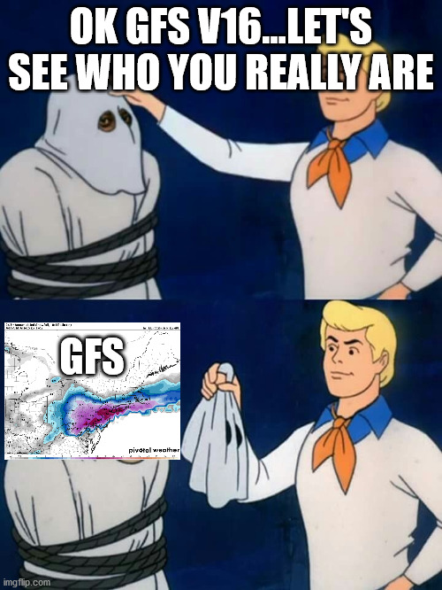
What time does the v16 goofus usually come out for 00z? I’m eager to watch it cave. -
Active mid December with multiple event potential
dendrite replied to Typhoon Tip's topic in New England
No I touched the ban button. -
Active mid December with multiple event potential
dendrite replied to Typhoon Tip's topic in New England
If I can’t get crushed then I cheer for cirrus. So I’m only jelly of CAR right now. -
Active mid December with multiple event potential
dendrite replied to Typhoon Tip's topic in New England
Just think of all of the dirty black snow in a few days.


