dendrite
-
Posts
75,078 -
Joined
Content Type
Profiles
Blogs
Forums
American Weather
Media Demo
Store
Gallery
Everything posted by dendrite
-
The AWPAGs precip gauges are really good now. With wind screens the % loss due to turbulence is significantly reduced. It looks like DDH has not received one yet so they still have a heated tipping bucket which will be prone to evaporation in S and tip spill issues in +RA. PSF has a heated tipping bucket as well.
-
Sucks for a lot of people, but I am loving it. 5 years ago I would be cheering -30F on, but I have other interests now that keep me cheering the cold away. (birds and bamboo)
-
No different than rain
-
It’s actually relatively cold under that cutoff ridge at the sfc in the prairie provinces and the upper plains...heavy heavy inversion and fake cold though.
-
That is a really weird H5 look for the season across the interior of NAMER.
-

Significant upper middle Atlantic S/CNE mix/snow potential Jan 3+
dendrite replied to Typhoon Tip's topic in New England
0.5” of meh -
10-20”...lol. I did that in 3 hours.
-
Significant upper middle Atlantic S/CNE mix/snow potential Jan 3+
dendrite replied to Typhoon Tip's topic in New England
A little deformation with that band from N PA up through there. Models have it fizzling out within a few hours so capitalize while you can. -
Significant upper middle Atlantic S/CNE mix/snow potential Jan 3+
dendrite replied to Typhoon Tip's topic in New England
It was pretty cool, but it turned to liquid water pretty fast. -
Significant upper middle Atlantic S/CNE mix/snow potential Jan 3+
dendrite replied to Typhoon Tip's topic in New England
It’s just frozen water. -
Significant upper middle Atlantic S/CNE mix/snow potential Jan 3+
dendrite replied to Typhoon Tip's topic in New England
Weird. Must be a resolution difference...but that’s a big difference in PA.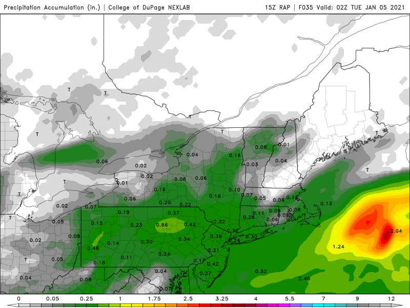
-
Significant upper middle Atlantic S/CNE mix/snow potential Jan 3+
dendrite replied to Typhoon Tip's topic in New England
Only looks like 0.30” QPF? -
Significant upper middle Atlantic S/CNE mix/snow potential Jan 3+
dendrite replied to Typhoon Tip's topic in New England
This is a 6hr forecast valid almost 12hrs ago? -
Usually when my chickens are enjoying winter the weenies on the forum are losing it....a definite negative correlation.
-
Significant upper middle Atlantic S/CNE mix/snow potential Jan 3+
dendrite replied to Typhoon Tip's topic in New England
Weenies on Georges Bank will enjoy it. -
Significant upper middle Atlantic S/CNE mix/snow potential Jan 3+
dendrite replied to Typhoon Tip's topic in New England

-
Significant upper middle Atlantic S/CNE mix/snow potential Jan 3+
dendrite replied to Typhoon Tip's topic in New England
I bet it has the highest 500 z score over Nunavut though. -
Significant upper middle Atlantic S/CNE mix/snow potential Jan 3+
dendrite replied to Typhoon Tip's topic in New England
The Terminator storm
-
1.6” here and nothing really melted...it just compacted a bit during the freezing rain and sleet. The high was only 35.7°.
-
I think that inch was heavier than the 34”.
-
Winding down. Another 0.7” after the flip back on top of the 0.9” of crap. So we’ll call it 1.6” final.
-
+SN now
-
Back over to snow. 31.6°
-
What a fail. Lol 28.8° with FZDZ Under an inch of SN/PL.