dendrite
-
Posts
75,093 -
Joined
Content Type
Profiles
Blogs
Forums
American Weather
Media Demo
Store
Gallery
Everything posted by dendrite
-
Congrats on the cold shot at the end of the gfs.
-

Watching closely .. February 1-3rd for moderate to major coastal event
dendrite replied to Typhoon Tip's topic in New England
Looks good for Union and Staffordville -
A little wine and a little NASDAQ and it's WAP time
-
You can almost envision salmon getting pulled right out of the water under the 400 microbars.
-
Guess this is a market thread now. We had talked about cutting out the market posts a few weeks ago with the COVID too. The milfs must be quarantining until they can get the vaccine.
-
Watching closely .. February 1-3rd for moderate to major coastal event
dendrite replied to Typhoon Tip's topic in New England
Hooooooose, in different area codes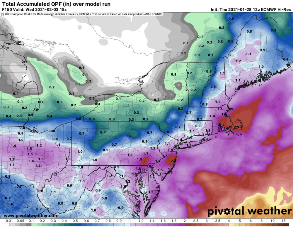
-
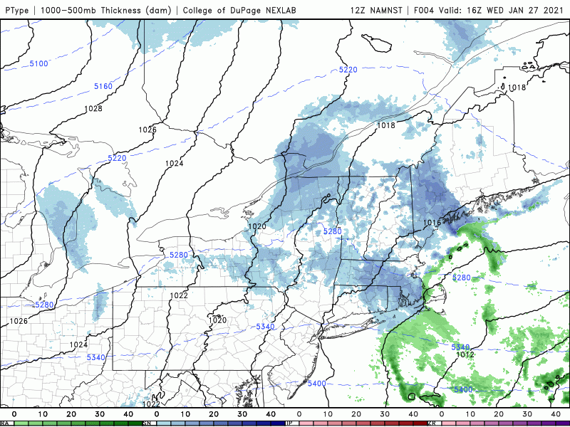
Active mid December with multiple event potential
dendrite replied to Typhoon Tip's topic in New England
lol -
Watching closely .. February 1-3rd for moderate to major coastal event
dendrite replied to Typhoon Tip's topic in New England
Yeah that moved around a bit. Some runs crushed LWM/ASH/MHT and eventually they became part of the subby zone. I forget what models looked like at d5 though...I'll have to go back through the 12/12 posts. -
Watching closely .. February 1-3rd for moderate to major coastal event
dendrite replied to Typhoon Tip's topic in New England
The suckerhole moved though. That’s the point. I wasn’t modeled to get crushed until 00z the night before. -
Watching closely .. February 1-3rd for moderate to major coastal event
dendrite replied to Typhoon Tip's topic in New England
Yeah, but they bounced around on modeling. I agree with Ray that you can have an idea of the evolution of the system. If it's a redeveloper you usually get that lower QPF zone between the dying primary and the maturing secondary. But a lot of things can happen between d5 to d0 to shift that around...that's all. I know I'm stating the obvious, but we tend to get fixated on what models are specifically showing at this lead time. -
Watching closely .. February 1-3rd for moderate to major coastal event
dendrite replied to Typhoon Tip's topic in New England
The day 5 QPF/ptype maps rarely come close to verifying...whatever the system. -
Inverted flakes here. 25.9F
-
Watching closely .. February 1-3rd for moderate to major coastal event
dendrite replied to Typhoon Tip's topic in New England
Yeah...I mean what did yesterday look like when it was 5-6d out? Kev will probably end up jacking when all is said and done. lol -
Watching closely .. February 1-3rd for moderate to major coastal event
dendrite replied to Typhoon Tip's topic in New England
Too many days out to be worried about suckerholes and such. We know how these can play out with the changes from d5 to go-time. -
30.1F -SHSN
-
Watching closely .. February 1-3rd for moderate to major coastal event
dendrite replied to Typhoon Tip's topic in New England
Nice crushing for E MA -
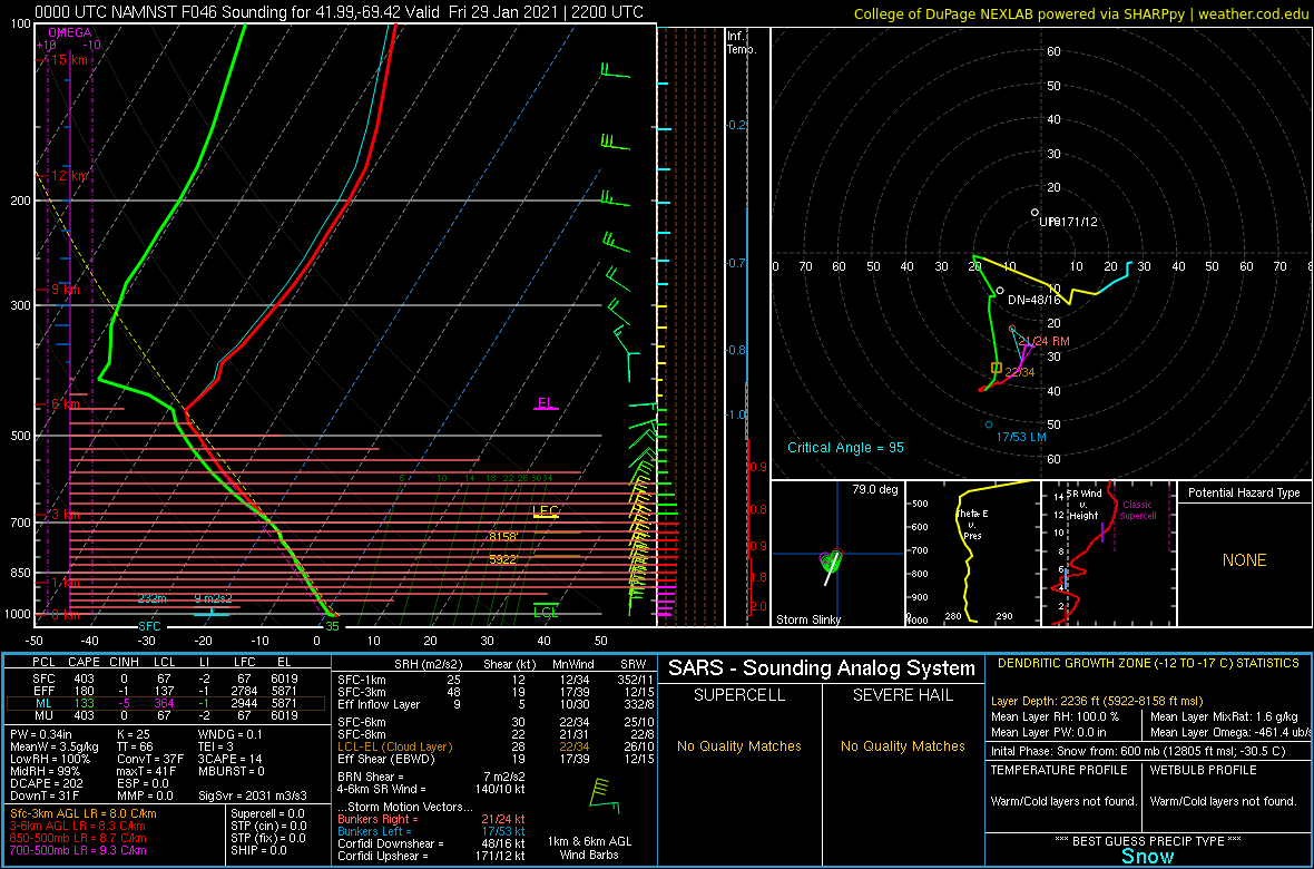
461 ubars in the DGZ
-
It’s localized and brief. It was a random click of a weenie gridpoint.
-
Found this a little offshore on the 3k NAM...lol

-
Watching closely .. February 1-3rd for moderate to major coastal event
dendrite replied to Typhoon Tip's topic in New England

-
I apologize to Scoot for helping you find a station.
-
Jan sun angle doin' its thang.
-
Yeah...has been modeled to
-
Kevin is confused
-
Little inv trough there before the stronger one