dendrite
-
Posts
75,092 -
Joined
Content Type
Profiles
Blogs
Forums
American Weather
Media Demo
Store
Gallery
Everything posted by dendrite
-
fyp
-
I noticed the BRO ASOS has been out for awhile and it was just 40° and OVC when they dropped obs.
-
Pretty crazy to see some of the obs down there. Mod to hvy snow in AR with single digits. -30s all over the upper midwest. Meanwhile, we meh.
-
Do you ever have good feelings?
-
My 2009 is still going. It’s about 800 miles away from 200k.
-
2009 was wet and raw. 2007 actually had quite a few crisp airmasses. 2001 brought a couple of freezes to Alex in late July. Other than that it’s been pretty meh.
-
RGEM is mostly pingers even up to Phin.
-
3k NAM tries to cold tuck SE NH before the actual cold front comes in from the west. That would probably create a nasty black ice situation on untreated surfaces Tue night. May have to watch that into NE MA too.
-
Adult diapers maybe?
-
Leon yore from the Mid Atlantic. Coldest Jan temp for LGA right here. Yes young weenies...we used to get arctic airmasses. https://twcclassics.com/watch.php?file=tingri-011994
-
I’m imagining some Kenny G “End of the Night” while seeing this.

-
Still not getting above freezing here during precip with that track. Just slash the snow and add more IP/ZR.
-
Precip is outta here by then. Is that just mixing us out on the backside?
-
We bust him, but I’m actually interested in following his Davis during this to see if he his high enough to hang around 30-31° or if he latently warms to that dreaded boring 32.2°.
-
https://www.pro-football-reference.com/boxscores/194311070det.htm
-
He is tied with Ray for big icing events.
-
Almost looks like Ryan circled that specifically around Met Herb. Maybe we can bring down some maple tapping equipment while those just barely to the SW rot around 32.3°.
-
0.5” with the new measuring method is really nbd. You’ll probably lose a couple of rotted oak branches.
-
It’s snow depth change...not snowfall. What you’re seeing there is the relatively coarse grid. So it’s basically calling the snowless portion the ocean.
-
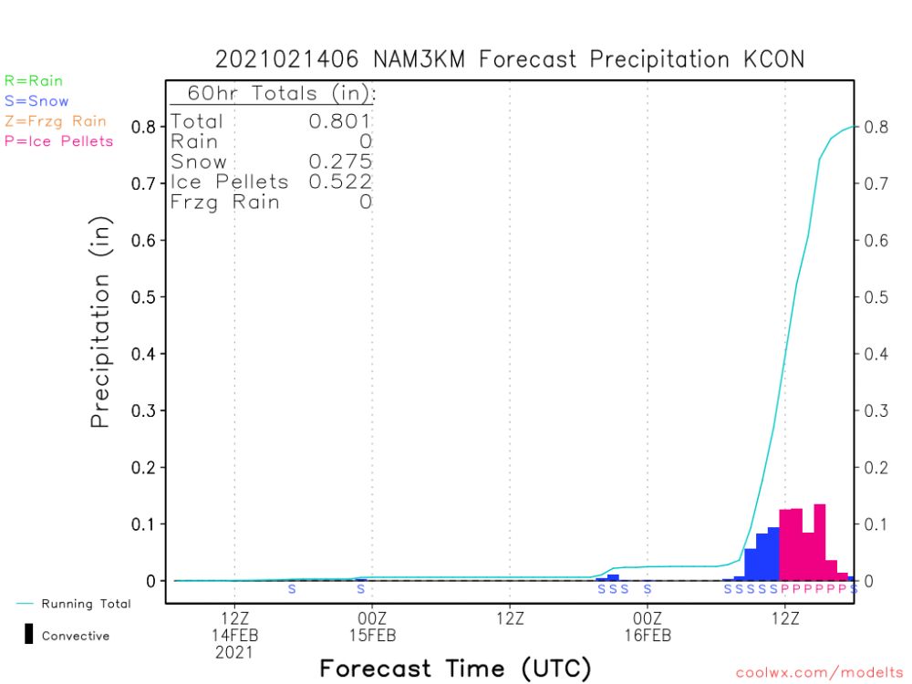
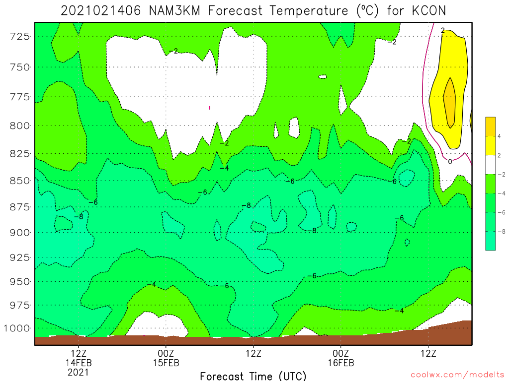
A little x-section through the 18z 3k NAM ptypes. You can see the fronto slope along 300K and some decent lift around here just N of the warm tongue moving in at 750mb. I noticed on the 12k the snow tries to fight off the sleet line just north of CON for a good 6 hours. Of course most of the lift is below the DGZ which is typical of these events although there is some midlevel banding near the Canadian border. I kinda miss it on this slice, but there's more lift in the DGZ around 500-600mb westward toward BTV/SLK.

-
Same ol' G(FS)
-
12k looked like about 50/50 snow and sleet for CON...3km maybe a little more sleet. You being a little more north helps. Hopefully we stay mostly snow. I hate clearing tons of sleet.
-
I feel like it busts more when the warm layer is around H85 and it’s the warmest model. But it usually nails these H7 warm tongues. I’m sure Will can name every system it failed on in the last decade, but I’m just going by my empirical feeling.
-
idk...I always feel like it does a decent job with the warmth aloft. Especially when it’s around 700mb.
-
It’s probably a little warmer just below H7 too. 3k nammy for example.