dendrite
-
Posts
66,905 -
Joined
Content Type
Profiles
Blogs
Forums
American Weather
Media Demo
Store
Gallery
Everything posted by dendrite
-
We bang.
-
Didn't do near the well or pear trees. We good.
-
Cells starting to fire just to my SW ahead of the main line. Let's get wet.
-
OVC 74/69 Kind of a dreary day...first in awhile.
-
Bring it on. I put fresh chicken poop around my trees. Water it in.
-
Looks like the few degC aloft we lost on the torch got added onto the cool down late week. Everything still on track...just less extreme.
-
Euro coming in a little warmer than previous run. Looks like the GFS and Euro from the other day met near the middle.
-
If the Euro verifies it'll be a few nice days with lower dews and nice below normal nights in the rad pits. BOS +1.4F** PVD +0.9F BDR +0.9F BDL +0.8F ORH +0.3F CON -0.8F
-
I know. Only +0.3F so far for ORH, but thankfully we bump that up the next few days and then cool down to place my call in the sweetspot.
-
Tough August for those who don’t look at models.
-
Easily on the 00z euro for those at 945ft.
-
Kinda. I remember growing up with many freezes in mid September and lately it's been difficult to even get below 40F by then. My first freeze last year was 10/14.

-
weather of preference for stds?
-
I had Coopers before this and those were OK for me as well.
-
Real beaut down there.
-
I had like 2 minutes of sun to bounce the temp up to 72°. 99% cloudy again.
-
So you like the Hankooks? I'm looking for something all-season and keep bouncing between the less expensive Firestone LE 2 and the pricier Michelin Defender LTX M/S. The truck is an 09 and pushing 180k so maybe the more expensive tire isn't even worth it.
-
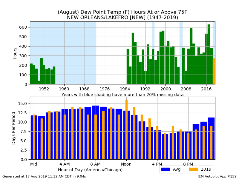
Dews are generally only as bad as your air circulation. 75F with calm winds...gag me. 75F with a nice breeze. Sign me up.
-
68F -DZ
-
Anyone have any recommendations on tires for a small truck (Ranger)? The Wild Country ones I got a couple of years ago were a disappointment. I probably could’ve rotated the tires more than I did, but one is completely bald and another has been leaking air through the valve stem. I do a good amount of highway driving, but they only made it 2 years.
-
That looked like a pretty warm euro run to me. A few days near 90°, a few days of a cool down, and then right back to warmth. Almost September by the end of that run. The seasons are fleeting.
-
If I lived down there I’d have a huge grove of moso.
-
Slightly below normal is the new much below. Mabye EWR can go another December without going below freezing?
-
Euro is still a nice cool down. GEFS aren’t buying the op either.