dendrite
-
Posts
66,943 -
Joined
Content Type
Profiles
Blogs
Forums
American Weather
Media Demo
Store
Gallery
Everything posted by dendrite
-

Winter 2020 New England Banter and General Obs
dendrite replied to CapturedNature's topic in New England
Freezing drizzle fo shizzle. 29.1F -
With high terrain to our nw it’s easy to squeeze out the precip with S and E flow...especially when it jacks up the PWATs.
-
NAM hittin that reefer hydro
-
I still have water in my basement from the last one. There’s no pack this time around, but the ground got a nice freezing the past couple nights. I wish we could torch into the 50s up here to thaw the ground out and let it soak in, but it’ll probably run off to my foundation and soak in there. At least I’m running 100ft of drainage pipe from my back gutters to the side of the yard so that half of my old problems now become my neighbor’s.
-
I mean, I'm usually on his side in the Dec vs Morch debates (not climo wise but emotion wise), but even that was a strange one for me. A festive grass covering instead of 17"?
-
Winter 2020 New England Banter and General Obs
dendrite replied to CapturedNature's topic in New England
1550ft. Nice weenie snow spot. -
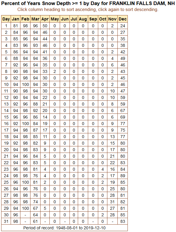
I'm going to arbitrarily select the 50% of days >1" threshold as the cutoffs for my pack season. So this would suggest roughly 12/12 through 4/1.

-
Who are you? Your family must be traveling or something. Or you’re worried about Christmas getting cancelled due to bad weather.

-
If we’re going to start flirting with subzero readings I’d like to get a few inches of snow on the ground to insulate some of my plants.
-
Actually that's not a bad run this far out for up here.
-
Toss is like a hot tub salad.
-
3 stooges
-
https://www.washingtonpost.com/news/capital-weather-gang/wp/2016/01/15/why-does-the-sun-still-rise-so-late-the-dark-mornings-of-january-explained/
-
Sunsets already getting later.
-
I'd rather have 0" in March.
-
Winter 2020 New England Banter and General Obs
dendrite replied to CapturedNature's topic in New England
Wow...that is a late sunrise. Mine was around 7am. -
Winter 2020 New England Banter and General Obs
dendrite replied to CapturedNature's topic in New England
Just one of those weenie sheltered valley things. There may be a little mixing above that point keeping the temp up around there too. But a lot of times these rad pits drops fast early, fog out, and then the surrounding areas catch up somewhat by sunrise as the fog thickens while the hills keep radiating. -
Winter 2020 New England Banter and General Obs
dendrite replied to CapturedNature's topic in New England
Maple Hollow? -
This is a good quick winter tutorial too. https://www.weather.gov/media/zhu/ZHU_Training_Page/winter_stuff/Winter_Stuff/Forecasting_P_Type.pdf
-
I had a longer reply to you at work that I never sent...oops. Paul covered the basics well. Anyway, COMET offers some good tutorials. Are you registered there? https://www.meted.ucar.edu/training_course.php?id=6
-
He doesn't flip to snow until it's about out of here. Maybe he gets a tenth or two of snow w.e. in the fantasy 84hr NAM.
-
It's not even really good for Rick.