

dendrite
-
Posts
75,078 -
Joined
Content Type
Profiles
Blogs
Forums
American Weather
Media Demo
Store
Gallery
Everything posted by dendrite
-

August Disco 2021. Do record dews continue?
dendrite replied to Damage In Tolland's topic in New England
you’re 71/64 at 11am lol -
August Disco 2021. Do record dews continue?
dendrite replied to Damage In Tolland's topic in New England
Clouds and a breeze. 73/65 down there seems like typical warmth off the water. The stronger caa is into N ME. A little of that may pinwheel in as a weak backdoor tonight. That low south of sne may help invite that in. Once we kick that out we can really start to blowtorch. The weekend may be more of a mild down. -
August Disco 2021. Do record dews continue?
dendrite replied to Damage In Tolland's topic in New England
Meh dews. Typical August humidity.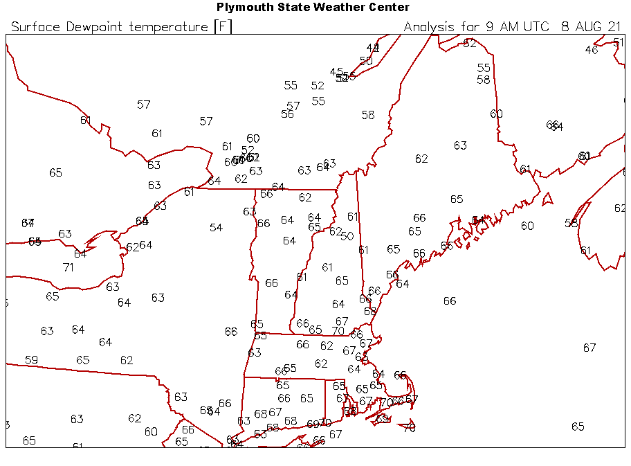
-
August Disco 2021. Do record dews continue?
dendrite replied to Damage In Tolland's topic in New England
We’ll see how close the Davis forecast is. Only 80.7 today…even I had 84.6.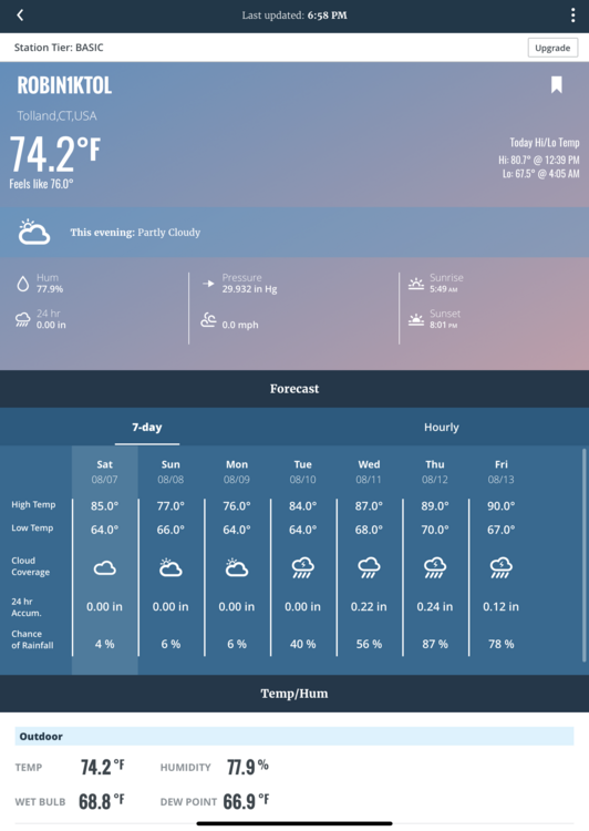
-
August Disco 2021. Do record dews continue?
dendrite replied to Damage In Tolland's topic in New England
I’d probably take a little over, but those 2 days could be meh. The real torch begins midweek. -
Hoyer?
-
August Disco 2021. Do record dews continue?
dendrite replied to Damage In Tolland's topic in New England
Another comfy morning. No humidity yet. 58.8° -
August Disco 2021. Do record dews continue?
dendrite replied to Damage In Tolland's topic in New England
CNN is worried about the Gulf Stream shutting down now. https://www.cnn.com/2021/08/06/world/climate-gulf-stream-collapse-warning-study-intl/index.html -
I love when 1/8 of a traffic light is sneaking into an empty square and you have to make a guess as to whether it counts or not.
-
Where’s wiz?
-
August Disco 2021. Do record dews continue?
dendrite replied to Damage In Tolland's topic in New England
20 straight days of 81F or lower here. Pretty crazy for peak heat climo. Only above 84F once since June (an 86F). -
This is the best the back lawn has looked since 2009. Three apps of the coop poop fertilizer in the spring followed by all of the rain and cool temps turned it into Ireland back there. The clover is going wild too (good thing). Unfortunately it’s been a little too wet and cool for the pawpaws that are north of their natural range. Some of them have yellowing leaves which look almost like they’re going into cool season dormancy rather than disease related. The 4” and 8” soil temps are 69° and I’ll assume they prefer 75-80° in the summer.
-
August Disco 2021. Do record dews continue?
dendrite replied to Damage In Tolland's topic in New England
70° clear Nice evening. Glad we here. -
August Disco 2021. Do record dews continue?
dendrite replied to Damage In Tolland's topic in New England

-
August Disco 2021. Do record dews continue?
dendrite replied to Damage In Tolland's topic in New England
Not sure. I've been looking at d16 mid level lapse rates. -
I'll agree about the natural immunity...but there's an obvious risk in getting there. i.e. you need to survive it without significant damage from the virus. If I had gotten it and recovered I wouldn't feel the need to be vaccinated. But I preferred to take my chances with the vax versus actual COVID. As long as the vaccines prevent severe disease we should just be rolling on ahead because the virus itself isn't going anywhere now. Not to get all Drago, but if people don't get it and die, they die. We're overpopulated anyway.
-
August Disco 2021. Do record dews continue?
dendrite replied to Damage In Tolland's topic in New England
Tropifail Deppresscho -
Older study, but just to play devil's advocate, imperfect vaccines can possibly help spread more severe mutations... https://journals.plos.org/plosbiology/article?id=10.1371/journal.pbio.1002198
-
How many harassments?
-
August Disco 2021. Do record dews continue?
dendrite replied to Damage In Tolland's topic in New England
Saved by Stein in the last 12hrs. Welcome back buddy. -
August Disco 2021. Do record dews continue?
dendrite replied to Damage In Tolland's topic in New England
Ugh. Holy shit euro. -
August Disco 2021. Do record dews continue?
dendrite replied to Damage In Tolland's topic in New England
On the line here with a little under 1”. Need a messenger shuffle eastward. -
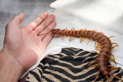
August Disco 2021. Do record dews continue?
dendrite replied to Damage In Tolland's topic in New England
You may need this. https://www.inaturalist.org/guides/3652 -
What about those with natural antibodies that don't need the vax? Just dumb all the way around.
-
August Disco 2021. Do record dews continue?
dendrite replied to Damage In Tolland's topic in New England
49.9°


