dendrite
-
Posts
75,084 -
Joined
Content Type
Profiles
Blogs
Forums
American Weather
Media Demo
Store
Gallery
Everything posted by dendrite
-

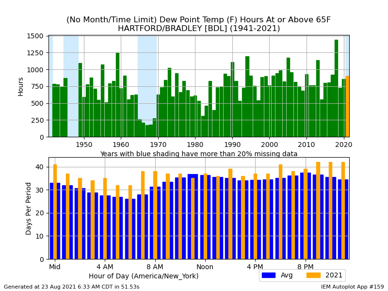
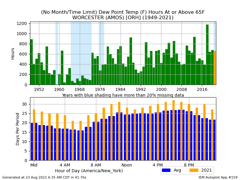
August Disco 2021. Do record dews continue?
dendrite replied to Damage In Tolland's topic in New England
That front for the weekend is coming in more like a backdoor (maybe side door?), but it trended cooler. That could make for a nice COC day Saturday here followed by a POS wedged Sunday as the warm front hangs up. Euro and goofus start next week on the warmer side and cool it down again for the 2nd half of the week. Looks like the 18z GFS is about to drop some legit cold for late next week, but it's probably overdone. -
August Disco 2021. Do record dews continue?
dendrite replied to Damage In Tolland's topic in New England
July and August flew by. A few more weeks and we'll be talking frequent 40s for lows. Summer is fleeting. -
August Disco 2021. Do record dews continue?
dendrite replied to Damage In Tolland's topic in New England
Sick of this shit. I can’t believe I’m typing this, but I’m ready for fall. -
August Disco 2021. Do record dews continue?
dendrite replied to Damage In Tolland's topic in New England
Did not expect to pull off over 1” overnight. We soaked. -
Had a JC death in SW NH a couple weeks ago.
-
It’s so wet there’s a chance Henri may redevelop over SNE.
-
Finally raining here. The chooks are not pleased.
-

-
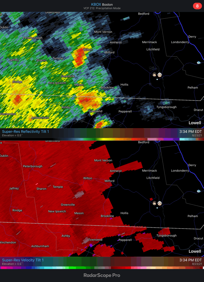
They’ve looked a bit interesting for a few hours…at least on BOX. It’s a tough area being so far from every site, but they flare up briefly and velocities kinda have that subtle look.
-
Beautiful day. Lots of sun, nice breeze, and u70s to near 80°.
-
August Disco 2021. Do record dews continue?
dendrite replied to Damage In Tolland's topic in New England
No black flies here in awhile. Just some no-seeums and the most vicious, relentless, dense amount of mosquitoes I’ve ever seen. -
I’m confused. The team approved his appointment and weren’t aware he’d have to sit 5 days for being unvaxxed? What about this would piss BB off about Cam? Or do you just mean he’ll get starting reps with the first teamers this week?
-
Yeah obviously they can’t really go in there now and set the forests ablaze. I’m just saying ecologically it’s a natural thing and healthy for the life cycle of the forest ecosystem. I usually put the planet before people (in a general sense) so when I say they need more burns I’m thinking for the long term benefit of the forest and not the people that feel compelled to live deep within them. People think they own the planet already as it is, but that’s a tangent for another day. lol
-
August Disco 2021. Do record dews continue?
dendrite replied to Damage In Tolland's topic in New England
The CFS was an obvious joke, but I agree…the seasonal maps don’t carry a lot of skill so I’m not sure what the purpose of the 6hr maps, out to d30, are for. The “aging” on was a d10 GFS map. There’s been hints of a front around that time on various op/ens runs. Maybe Hadley puts the block on come verification time. But agree with your post. The models start sensing that cooler air building in the higher latitudes and rush them into the CONUS prematurely. It seems like once one of those legit across the bow airmasses verifies it’s the green flag into the descent of autumn…notsomuch below normal temps, but at least a higher frequency of transitory airmasses. -
Pics or it didn’t happen.
-
I had a loose caliper once that I would hear at low speeds, but I didn’t hear it at higher speeds. My guess was that the sound became a higher frequency the faster I went and my ears weren’t able to pick up on it as well. Otherwise I’m not sure why it would improve at higher speeds vs lower.
-
August Disco 2021. Do record dews continue?
dendrite replied to Damage In Tolland's topic in New England
If you’re looking for just August here’s ORH.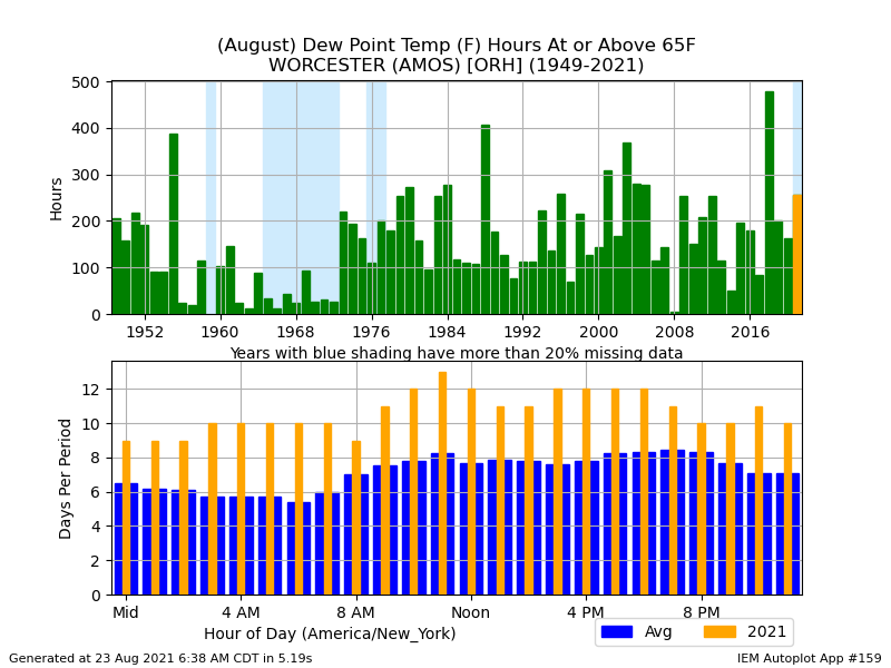
-
August Disco 2021. Do record dews continue?
dendrite replied to Damage In Tolland's topic in New England
-
August Disco 2021. Do record dews continue?
dendrite replied to Damage In Tolland's topic in New England
Aged better than expected. -
Not much of a car guy, but are your brake pads worn out? Maybe the caliper isn’t fully releasing and you’re getting some friction that you only hear at lower speeds?
-
Probably a little too far north up here for tomorrow which is just as well. I’m okay with my quarter inch of sheet drizzle today.
-
August Disco 2021. Do record dews continue?
dendrite replied to Damage In Tolland's topic in New England
A little snow up in the passes of WY this morning. -
August Disco 2021. Do record dews continue?
dendrite replied to Damage In Tolland's topic in New England
Record cold on the 606hr CFS.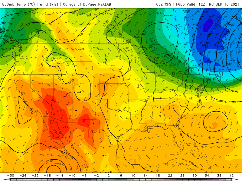
-
Maybe you’re in the eye?
-
New England has jackpotted for rain the last 2 months. You can have this.