dendrite
-
Posts
75,069 -
Joined
Content Type
Profiles
Blogs
Forums
American Weather
Media Demo
Store
Gallery
Everything posted by dendrite
-

December 2021 Obs/Disco...Dreaming of a White-Weenie Xmas
dendrite replied to 40/70 Benchmark's topic in New England
Back down to 38°. Super torch fail this week. -
December 2021 Obs/Disco...Dreaming of a White-Weenie Xmas
dendrite replied to 40/70 Benchmark's topic in New England
What a miserable day. 39.6° and heavy fog off of a high of 41°. The front is on the north side of CON right now. MHT airport was partly sunny and 56° on the car thermo…upper 40s and BKN at CON. You hit that cold air/fog like a wall. -
Looks like all systems go up here. Euro pounds around midnight Sat night.
-
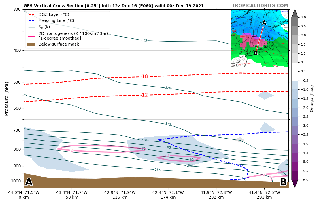
That cold knifes in just in time for SNE to get frozen. Looks like the best fronto rides up the 295K isentropic surface while the warm tongue comes in up around 310K...gotta love the mixed bag overrunning events.

-
The euro is near warning criteria up here now. Mixing is up to S NH so there’s plenty of wiggle room. That should guarantee a white Christmas.
-
Pingers right up to the coop after a decent thump.
-
December 2021 Obs/Disco...Dreaming of a White-Weenie Xmas
dendrite replied to 40/70 Benchmark's topic in New England
Snowing pretty well right now. -
December 2021 Obs/Disco...Dreaming of a White-Weenie Xmas
dendrite replied to 40/70 Benchmark's topic in New England
The only thing we do well is snow and backdoors. -
December 2021 Obs/Disco...Dreaming of a White-Weenie Xmas
dendrite replied to 40/70 Benchmark's topic in New England
And it probably won't mix out of the 30s/40 here. -
December 2021 Obs/Disco...Dreaming of a White-Weenie Xmas
dendrite replied to 40/70 Benchmark's topic in New England
Your snow maps aside, this run looked better on the initial front end down there...there's a quick 2-3hr burst. -
December 2021 Obs/Disco...Dreaming of a White-Weenie Xmas
dendrite replied to 40/70 Benchmark's topic in New England
-
December 2021 Obs/Disco...Dreaming of a White-Weenie Xmas
dendrite replied to 40/70 Benchmark's topic in New England
The primary is more amped. We get a bit of a better cold bleed and front end thump down in CT. But it's way better for NNE. -
December 2021 Obs/Disco...Dreaming of a White-Weenie Xmas
dendrite replied to 40/70 Benchmark's topic in New England
Pretty solid bump north. (compared to 00z) -
December 2021 Obs/Disco...Dreaming of a White-Weenie Xmas
dendrite replied to 40/70 Benchmark's topic in New England
Euro should finally deliver up here. -
December 2021 Obs/Disco...Dreaming of a White-Weenie Xmas
dendrite replied to 40/70 Benchmark's topic in New England
Which means it'll be the most north model in a few minutes. -
December 2021 Obs/Disco...Dreaming of a White-Weenie Xmas
dendrite replied to 40/70 Benchmark's topic in New England
Yeah I was...lol -
December 2021 Obs/Disco...Dreaming of a White-Weenie Xmas
dendrite replied to 40/70 Benchmark's topic in New England
If the op was warm and ensembles colder he would be all over the GEFS. He's heavy, heavy invested in this one. -
December 2021 Obs/Disco...Dreaming of a White-Weenie Xmas
dendrite replied to 40/70 Benchmark's topic in New England
Christmas morning in trapper hats and parkas. Enjoy. -
December 2021 Obs/Disco...Dreaming of a White-Weenie Xmas
dendrite replied to 40/70 Benchmark's topic in New England
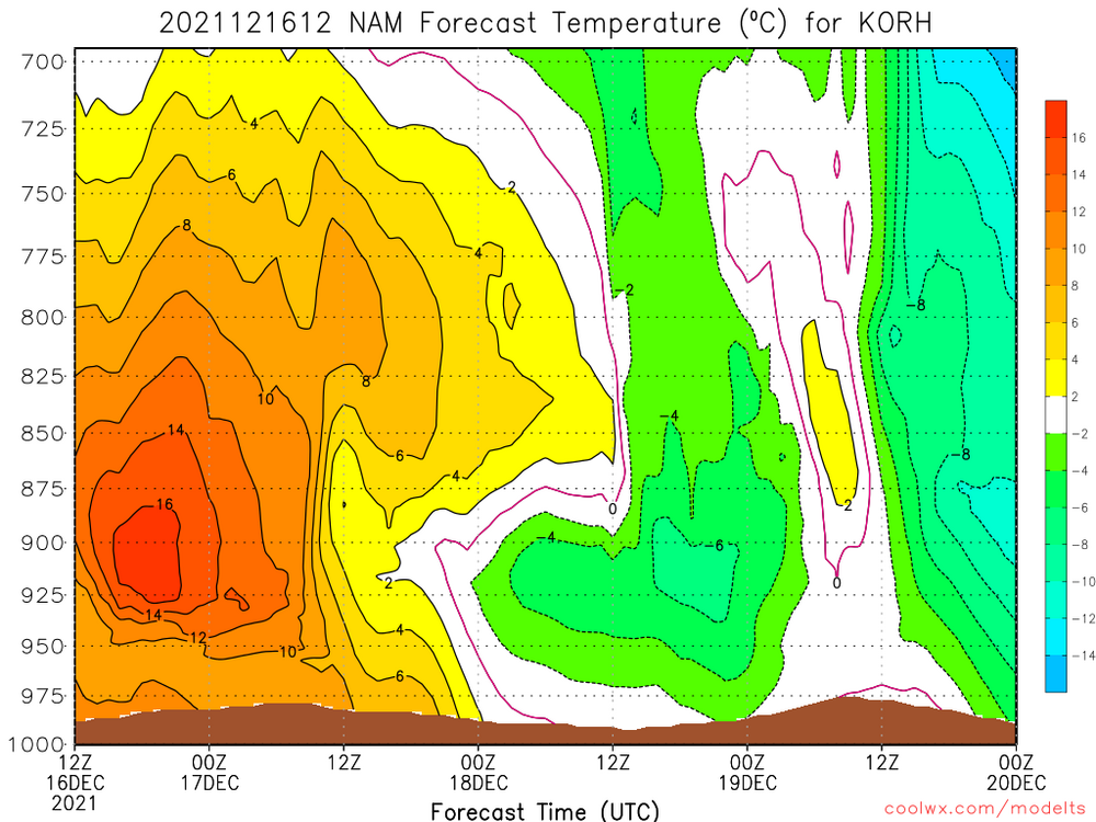
Still have the warm tongue above H85 to deal with. GFS has the max profile temps around H8-75. That can change, but you know how these things usually go...warmer tongues and cooler low levels. Keep the warm punch lower to near H85 and get a good thump of upglide before the tongue goes above freezing and you can get a good front end dump. -
December 2021 Obs/Disco...Dreaming of a White-Weenie Xmas
dendrite replied to 40/70 Benchmark's topic in New England
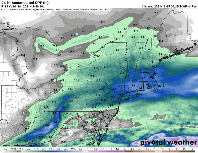
How was Jan 11 there? We got the big deform band here. 21” from that event. -
December 2021 Obs/Disco...Dreaming of a White-Weenie Xmas
dendrite replied to 40/70 Benchmark's topic in New England
-
December 2021 Obs/Disco...Dreaming of a White-Weenie Xmas
dendrite replied to 40/70 Benchmark's topic in New England
I figured this was heavily edited by you, but nope…it came right off of Freak’s fingertips. His wife just booked another trip to the tropics without him. -
December 2021 Obs/Disco...Dreaming of a White-Weenie Xmas
dendrite replied to 40/70 Benchmark's topic in New England
My MIL leaves on the 21st. That system looks like a problem. -
I’ve made it so all new account registrations require administrator validation so that should put an end to that…unless there’s a few that already snuck in and are waiting to spam another day. Sorry about that everyone.
-
December 2021 Obs/Disco...Dreaming of a White-Weenie Xmas
dendrite replied to 40/70 Benchmark's topic in New England
Not much warmth or wind here, but it was still enough to wipe out the snow minus the piles.