dendrite
-
Posts
67,071 -
Joined
Content Type
Profiles
Blogs
Forums
American Weather
Media Demo
Store
Gallery
Everything posted by dendrite
-
You got that in LEW or were you closer to the coast?
-
Should reach NYC in time for climo norms to start trending cooler.
-
1000 joules at 300hr. Epic.
-
It's amazing how many nasty invasive species are out there...insects and plants. My yard would've looked a lot different a couple hundred years ago.
-
lol...I'm sure that would go well. "Hunny...it's a brown tail moth rash, I swear."
-
So those overly excited about the drought should keep their weenie inside?
-
Did you let them mate on the back of your neck?
-
GFS with 50s and rain up here during the day on Saturday.
-
The NAM is a good model right?
-
If it stays a bit north of us it may not be that bad at all. Maybe some self destructive sunshine and scattered afternoon showers?
-
I trust Ryan with content going forward, but that relationship with Joerg is strange to me. I couldn’t understand why they partnered and then Joerg beefed up weather.us and paywalled some of that too. I sense more stability with WB.
-
Friend’s dad lifting your 90lb body out of the hot tub?
-
Stealing my rain
-
53.5F Nice refreshing morning.
-
We dry 05/16 62.7 46.4 T 22 0.0 0 05/17 68.8 45.9 0.00 14 0.0 0 05/18 68.4 48.3 T 12 0.0 0 05/19 65.5 39.5 0.00 15 0.0 0 05/20 70.4 38.0 0.00 12 0.0 0 05/21 80.5 38.5 0.00 14 0.0 0 05/22 84.5 49.8 0.00 18 0.0 0 05/23 74.7 40.8 0.00 19 0.0 0 05/24 68.3 36.0 0.00 11 0.0 0 05/25 64.8 41.0 T 10 0.0 0 05/26 83.4 53.9 0.00 11 0.0 0 05/27 89.3 59.2 0.00 13 0.0 0 05/28 81.4 62.0 T 18 0.0 0 05/29 85.3 68.6 0.00 22 0.0 0 05/30 74.8 59.1 0.00 18 0.0 0 05/31 59.5 36.3 0.00 24 0.0 0 06/01 60.5 35.5 T 21 0.0 0 06/02 66.6 37.0 0.01 13 0.0 0 06/03 72.8 52.1 0.10 14 0.0 0 06/04 82.3 52.3 0.00 14 0.0 0 06/05 81.8 62.8 0.03 15 0.0 0 06/06 82.4 56.0 0.20 25 0.0 0 06/07 66.9 49.3 0.00 23 0.0 0 06/08 73.0 46.0 0.00 25 0.0 0 06/09 70.4 53.0 0.00 12 0.0 0 06/10 73.1 53.9 T 16 0.0 0 06/11 78.9 54.7 0.34 17 0.0 0 06/12 78.9 53.3 0.00 16 0.0 0 06/13 64.7 45.8 0.00 16 0.0 0 06/14 68.5 46.0 0.00 7 0.0 0 06/15 70.3 51.6 0.00 7 0.0 0 06/16 78.1 48.0 0.00 10 0.0 0 06/17 82.2 48.2 0.00 10 0.0 0 06/18 87.2 53.4 0.00 9 0.0 0 06/19 87.4 61.8 0.00 11 0.0 0 06/20 87.1 65.7 0.05 7 0.0 0 06/21 88.5 63.5 T 10 0.0 0 06/22 82.4 65.6 0.00 11 0.0 0 06/23 87.3 63.8 0.00 15 0.0 0 06/24 82.1 65.4 T 15 0.0 0
-
0.73" now in the last 40 days.
-
Pretty much. When the droplets become too heavy for the updrafts to support them they fall to the ground. Of course in glaciated clouds you start dealing with the bergeron process instead of collision coalescence. So you have a supercooled condensation nuclei and differences in vapor pressure between the ice crystals and water droplets. The ice crystals readily gain H20 from the vapor and grow according to their respective habit at a given temperature and RH...ie snow crystal growth by deposition. That's the majority of how most of our precipitation forms.
-
Has looked like garbage outside of VT and NNE for days.
-
Did you see my reply about soil moisture?
-
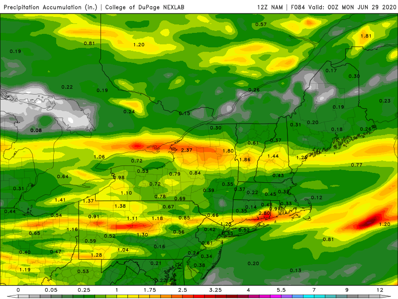
I will take those euro amounts for Sat and run. Could be a wet, cool afternoon up here. GFS kicking its ass again.
-
Probably not with a 5 min mean.
-
Bone dry. Those Davis stations use Watermark soil moisture sensors. 200 centibars is the dry limit. 0cb is satuated. So 6" deep is very dry and 12" has a bit of moisture, but is still on the dry side. Usually you're supposed to pull them in the spring and reinsert them so that there's good contact between the sensor and soil. Freeze/thaw cycles can cause the soil to pull from the sensor with time.
-
I got a rock
-
GFS is an SOS in NNE this weekend.