dendrite
-
Posts
66,889 -
Joined
Content Type
Profiles
Blogs
Forums
American Weather
Media Demo
Store
Gallery
Everything posted by dendrite
-

December 2024 - Best look to an early December pattern in many a year!
dendrite replied to FXWX's topic in New England
Somewhere around there. This is ugly. Looks like somewhere near this 7/1 it got really bad. NSFW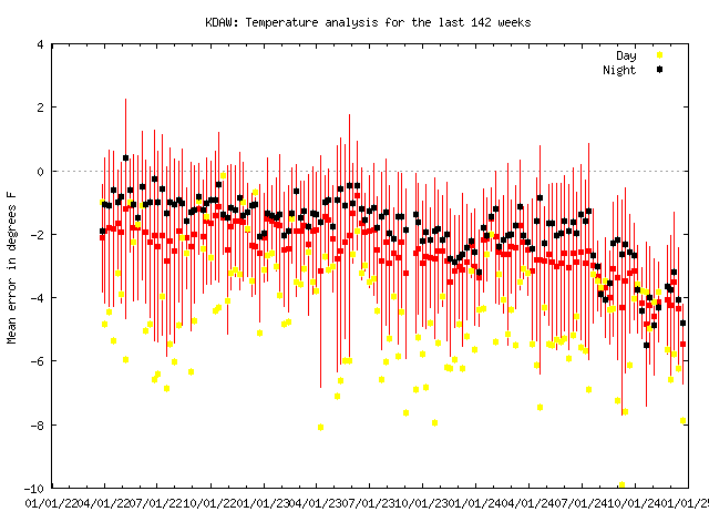
-
December 2024 - Best look to an early December pattern in many a year!
dendrite replied to FXWX's topic in New England
We need to put a putting green around it to get Mekster on it. -
New England Winter 2024-25 Bantering, Whining, and Sobbing Thread
dendrite replied to klw's topic in New England
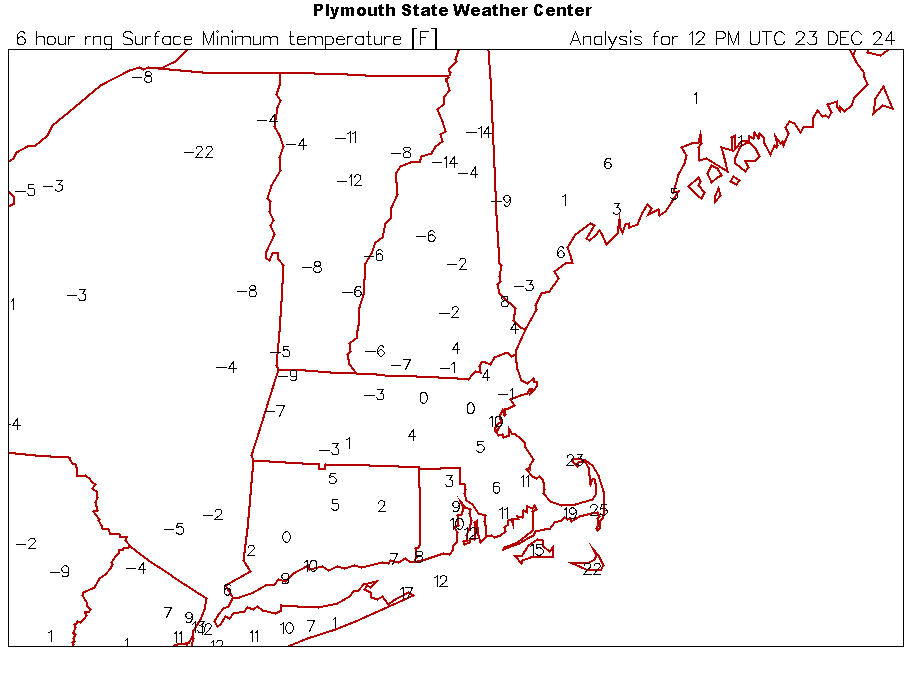
Middleboro right next door had -26°. Up here CON had -23°. Maybe the -30s are too extreme, but it was apparently a good night for radiating. -
December 2024 - Best look to an early December pattern in many a year!
dendrite replied to FXWX's topic in New England
Thoughts and prayers to the ASOS. A good +7F today.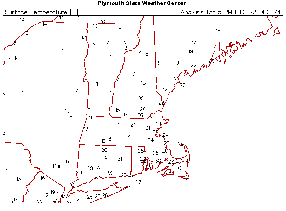
-
December 2024 - Best look to an early December pattern in many a year!
dendrite replied to FXWX's topic in New England
29° at noon!
-
This may be the best video I’ve seen explaining snow crystal microphysics. Good stuff.
-
Sorta. You can magnify the crystals to see if the hexagonal crystalline structures are still in tact of if they’re broken up into pieces. Imagine the crystal formations on this site https://www.snowcrystals.com and then just seeing fractured pieces in blowing and drifting snow. There’s a reason why those drifts get dense and hard packed.
-
December 2024 - Best look to an early December pattern in many a year!
dendrite replied to FXWX's topic in New England
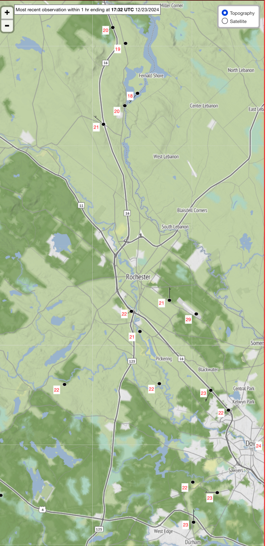
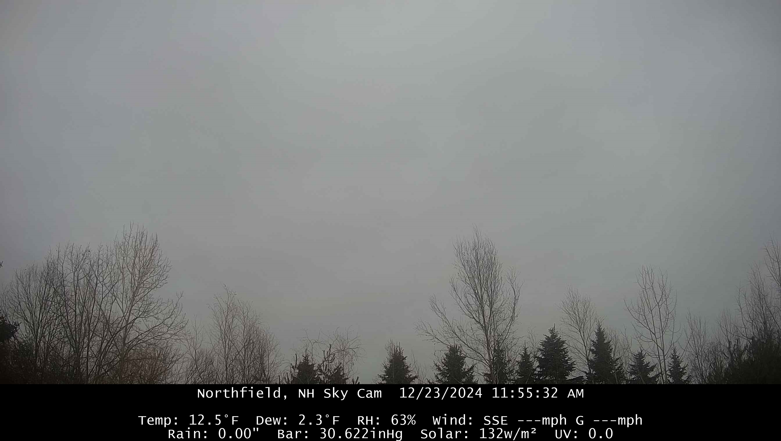
Struggling up here. 12.5° and deep OVC. Looks like we’re stuck in it all day.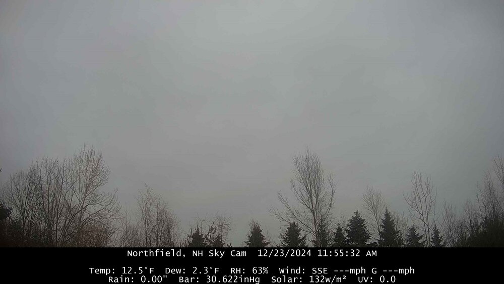
-
35kt winds in the DGZ doesn’t sound that extreme to me.
-
December 2024 - Best look to an early December pattern in many a year!
dendrite replied to FXWX's topic in New England
Van Buren used to hold the old coop record before all of those automated river HADS sites got put in. Non-MWN NH record is -46°F at Pittsburg. I don’t think anyone in NNE has theoretically gotten much colder than -50°F in the last 150 years so toss that -64°F further than DAW. -
December 2024 - Best look to an early December pattern in many a year!
dendrite replied to FXWX's topic in New England
Was she married to this guy? -
Yeah…think of those deformation bands where you have different flow trajectories coming together and stretching of the parcels yet we’re still pulling 25:1 at the sfc. It’s not as gusty above the frictional layer either so there’s probably less opportunity for collisions?
-
December 2024 - Best look to an early December pattern in many a year!
dendrite replied to FXWX's topic in New England
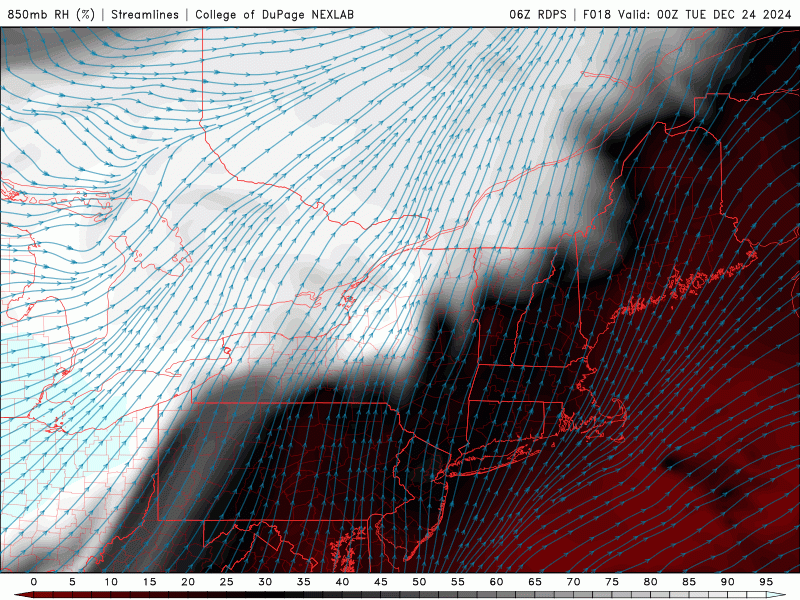
+3C 850s with a min of 9F at CON. Not sure I’ve seen it that extreme. lol But yeah, we’re super dry and mixed right off the BL so there’s some potential for high end inversions.
-
December 2024 - Best look to an early December pattern in many a year!
dendrite replied to FXWX's topic in New England
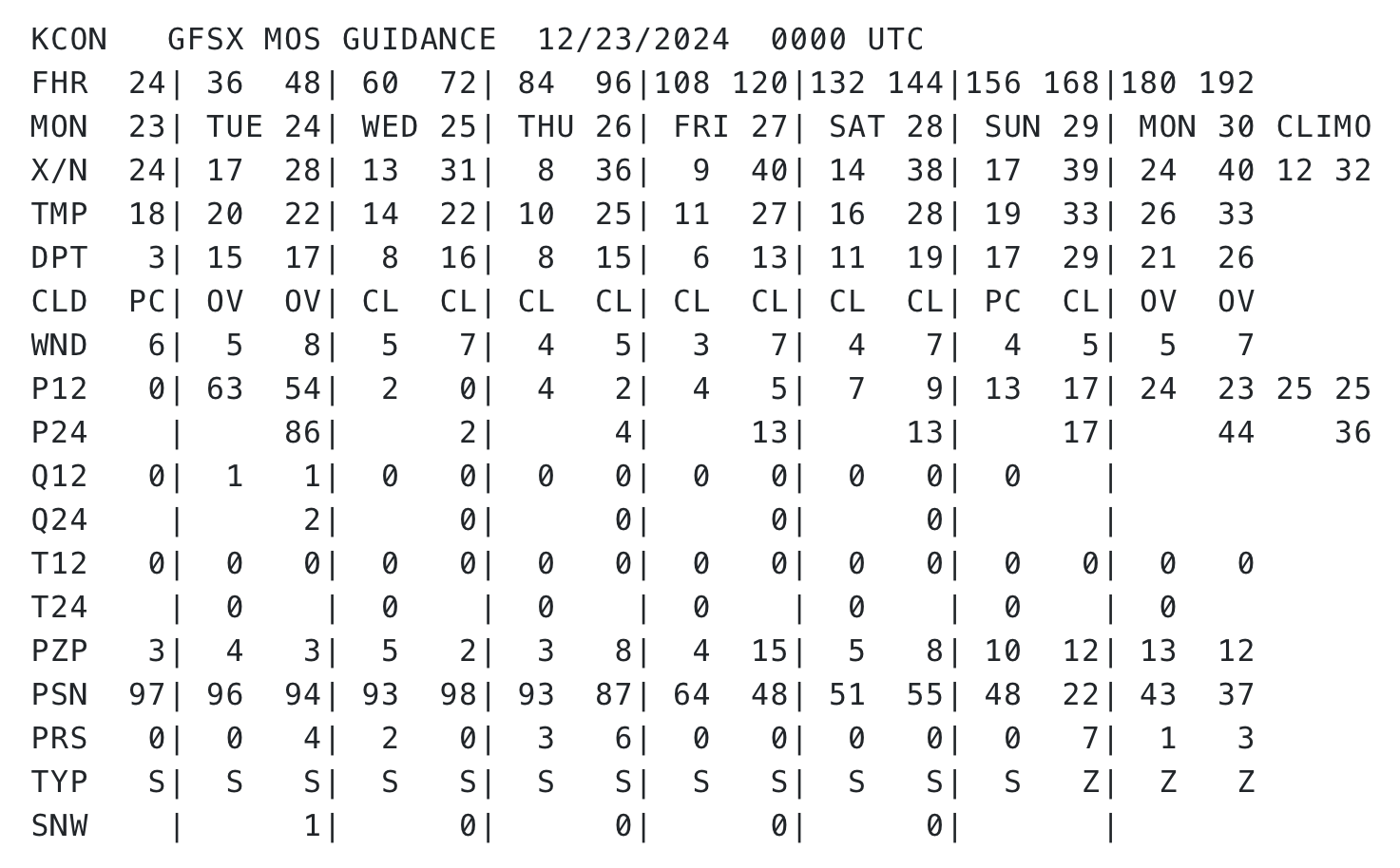
MOS is really going wild with the radiating after Xmas despite well AN midlevel temps. Seems too aggressive to me, but it’ll be interesting to see how it plays out.
-
I really need one more tick south to get into the 1-3” here. There’s that initial finger of fronto that pushes through and then the lower level dry slot for SNE and most of CNE before the fropa approaches. Best accums will be north of that dry nose moving W to E
-
December 2024 - Best look to an early December pattern in many a year!
dendrite replied to FXWX's topic in New England
Ginx already mentioned WU. This is a good one too. https://www.wrh.noaa.gov/map/?obs=true&wfo=sto -
December 2024 - Best look to an early December pattern in many a year!
dendrite replied to FXWX's topic in New England
https://mesowest.utah.edu/cgi-bin/droman/mesomap.cgi?state=MA&rawsflag=3 Here’s the Davis one. You may need to change it from AQ to temp. https://www.weatherlink.com/map -
December 2024 - Best look to an early December pattern in many a year!
dendrite replied to FXWX's topic in New England
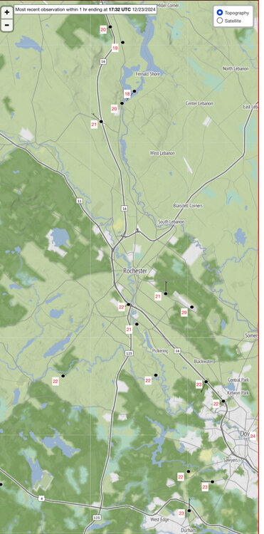
I don’t see one low of -10° or colder in MA.
-
December 2024 - Best look to an early December pattern in many a year!
dendrite replied to FXWX's topic in New England
- Actually thought you’d be colder than that in the valley. -2° used to be a warm morning out there. -
December 2024 - Best look to an early December pattern in many a year!
dendrite replied to FXWX's topic in New England
Still dropping. -1.6° -
December 2024 - Best look to an early December pattern in many a year!
dendrite replied to FXWX's topic in New England
$$$$$
-
December 2024 - Best look to an early December pattern in many a year!
dendrite replied to FXWX's topic in New England
-1.2° -
Nah I’ll stay right here and continue bitching about it.
-
December 2024 - Best look to an early December pattern in many a year!
dendrite replied to FXWX's topic in New England
High 10.8°. Colder than my lowest of 13° last year…probably have to go back to the 7° on 2/4/23. -
December 2024 - Best look to an early December pattern in many a year!
dendrite replied to FXWX's topic in New England
9.5° At least we gain 3s of daylight today