dendrite
-
Posts
67,071 -
Joined
Content Type
Profiles
Blogs
Forums
American Weather
Media Demo
Store
Gallery
Everything posted by dendrite
-
Noticeable wind shift here and getting a weak drop in the dews. Clouds knocked the temp back a bit too. 86/68
-
Do you think blue ash would grow well up here? We’re pretty far NE from its native range. I’ve read that it has shown the best resilience to EAB although maybe that’s just a case of them preferring other ash first. Maybe the chemical that helps produce the blue dye inside the bark isn’t very appetizing?
-
They were arguing over whether the meniscus was at 109F or 110F. A few thought it was chamber weather because of the low mins, but most agreed it was a torch and that they would install air conditioners if such a thing existed.
-
85/71 gross
-
My green ash trees are producing a decent amount of seeds. Haven’t checked the sugar maple yet. But we have plenty of the ash and red maples if you need any to spread out there before winter. Maybe the shrubby willow is pussywillow?
-
You would’ve liked 09. I think I needed more heat than AC that month. lol
-
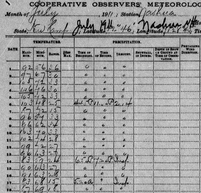
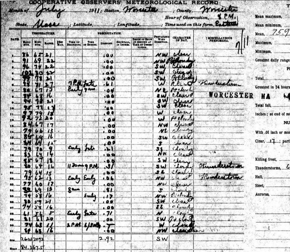
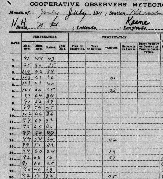
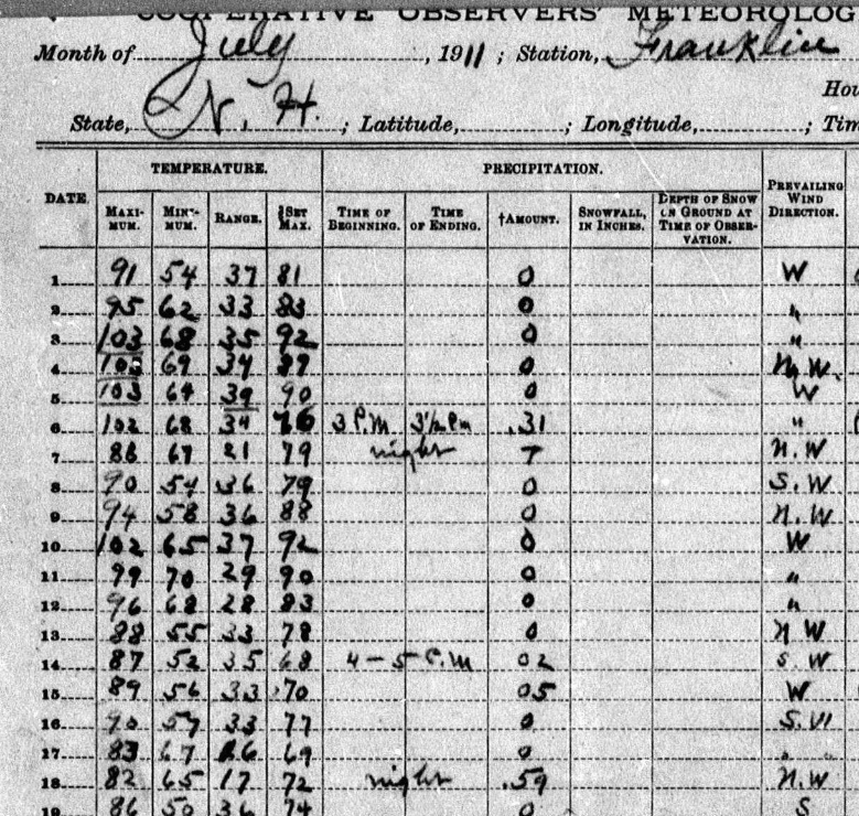
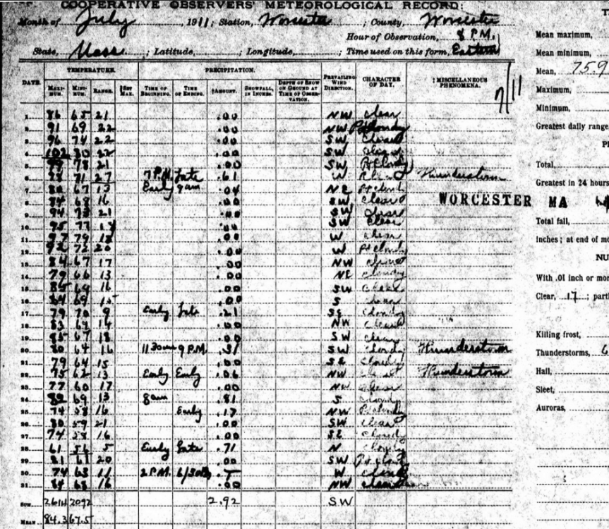
I assume there were a lot more fields back then with the abundant tree cutting. I wonder how much that helped the region heat up and radiate at night. It tended to be more arid times back then too as the poor farming practices were beginning in the plains and we had fewer GHGs. So those airmasses coming from our west had to be extremely hot and dry...sonoran for like 2 weeks. Being deep in river valleys probably helped Keene and Franklin decouple while Nashua stayed a bit mixed. Of course there’s a “yore” factor where you sometimes have to ask if the data passes the smell check. Many had differing obs times and differences in instrumentation, siting, and observing methods. Maybe Chris has access to info describing what each site used during the history of the station’s existence. But there’s enough consistency in the numbers between multiple sites in multiple states to know these days and days of 100s were legit.
-
MHT with a low of 77°. 72.3° at the casa.
-
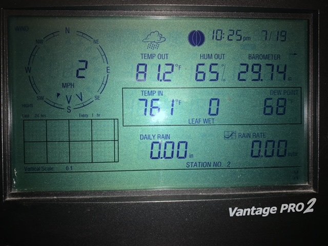
81.2° Not sure I’ve ever been this warm here at this time of night.
-
MHT 85F at 11pm. 79F here. About as bad as it gets this time of night.
-
A really strange month.

-
-
Nah I'm installed. Still 87F at MHT 935p...gah. That's not as bad as July 1995, but it's pretty close.
-
Jesus. Temp shot up to 83° when the wind picked back up. Heat burst?
-
Can't use BDL so we're onto CAR?
-
lol
-
I wonder how this would've played out at the current site.
-
7/19 100 7/20 100 7/21 101 Now that's how you do a heat wave.
-
BDL was 1F off from the '91 record too.
-
You're fast. I've been refreshing every 10 minutes. Looks like ORH was more in the heat zone with elevation influence while BOS/PVD suffered the LIS taint.
-
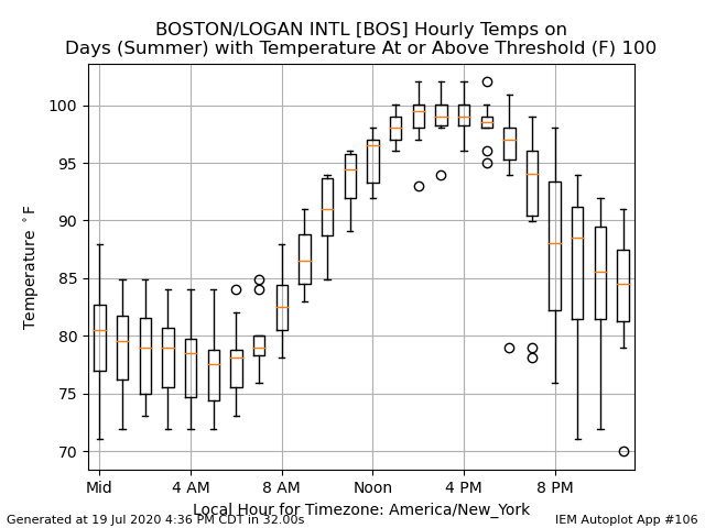
Was on the ISU site and found this. Turns out 90F @ 9am is very rare for BOS on their 100F days. 10F after 10am is more fitting.
-
Year estimate? WPB hasn't hit 100F since 1942 and FLL has nothing in their records over 100F. They did hit 100F on 6/22/09.
-
Depends where you are. For BOS, sure. Although I agree this isn’t really memorable for anyone. It was still high end over the interior.
-
GYX CLI is in. CON 96 MHT 98
-
And here comes the anvil exhaust into WNE just in time to blanket us this evening...should be a toasty night.