dendrite
-
Posts
66,758 -
Joined
Content Type
Profiles
Blogs
Forums
American Weather
Media Demo
Store
Gallery
Everything posted by dendrite
-

TS Fay - Drought ending Rains and Severe Convection
dendrite replied to weatherwiz's topic in New England
way west like the goofus -
TS Fay - Drought ending Rains and Severe Convection
dendrite replied to weatherwiz's topic in New England
Just looking at vis...that exposed llc is a bit elongated looking. there is some inflow toward the exploding convection to the NE so maybe we can drop pressures enough there to shift the main circulation eastward like a secondary triple-point low. The 3k NAM sorta does this, but hooks it more westward anyway into DE/ACY. -
TS Fay - Drought ending Rains and Severe Convection
dendrite replied to weatherwiz's topic in New England
ICON tracks right over SNE. 1-3" for most. -
TS Fay - Drought ending Rains and Severe Convection
dendrite replied to weatherwiz's topic in New England
Spoiler
- 647 replies
-
- 11
-

-

-
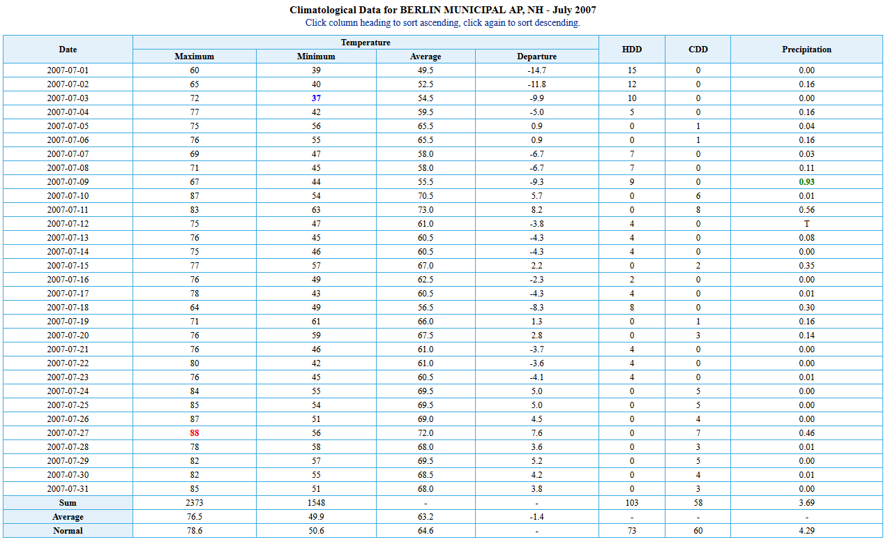
84/71...not too bad
-
TS Fay - Drought ending Rains and Severe Convection
dendrite replied to weatherwiz's topic in New England
3k is still pretty far west. GFS tiebreaker? -
TS Fay - Drought ending Rains and Severe Convection
dendrite replied to weatherwiz's topic in New England
lollis to 10? -
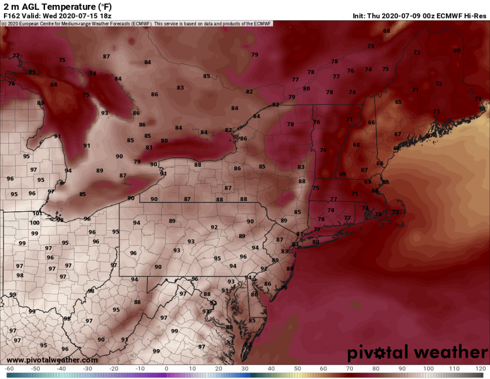
Maybe, maybe not. The GFS goes 7/1911 in the extended with 5+ days of 95-100+ in SNE. Lalaland though.
-
New England gon' New England
-
69/67 after a low of 64.8°. Finally getting the fog to dissipate.
-
TS Fay - Drought ending Rains and Severe Convection
dendrite replied to weatherwiz's topic in New England
Heh...euro is way east.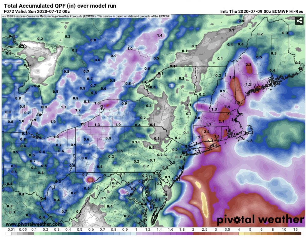
-
This wasn't even that cold, but it's funny how cold a BN July can look up...especially if we're doing it with cP airmasses.
-
I sometimes get Raynaud's if I get chilled. I used to go out and take temp readings in -20s back when I was in HS, but today I take my cold about as well as Wizzy.
-
If we go below 70F inside during the winter I fear we've run out of oil or something...lol.
-
67.7/65 May have to actually turn the fans off.
-
No sweat here. 70 out and 75 in already. We’re pretty much used to it right now with the stepping up through the season. I’m disappointed in the heat tolerance from SNEers.
-
Nonstop thunder, but I doubt much makes it to me before dissipating.
-
Have not installed the ACs yet, but considering it tonight for tomorrow. 78/69 in the bedroom right now, but I have the walmart window fans stacked and on high blowing in 71.5/68 air. This is tolerable. MEX TEXT BULLETIN K1P1 GFSX MOS GUIDANCE 7/08/2020 1200 UTC FHR 24 36| 48 60| 72 84| 96 108|120 132|144 156|168 180|192 THU 09| FRI 10| SAT 11| SUN 12| MON 13| TUE 14| WED 15|THU CLIMO N/X 63 91| 62 84| 67 82| 65 84| 63 85| 62 83| 61 82| 61 54 79 TMP 69 79| 67 76| 69 76| 69 76| 69 74| 66 74| 65 73| 67 DPT 67 70| 66 70| 67 72| 67 70| 66 69| 65 65| 63 65| 64 CLD PC PC| PC OV| OV OV| OV OV| PC OV| OV OV| OV PC| PC WND 1 3| 0 4| 4 4| 2 4| 3 4| 3 4| 2 8| 1 P12 4 2| 3 42| 89 75| 54 38| 22 52| 41 36| 31 21| 21999999 P24 5| 42| 90| 70| 67| 58| 43| 999 Q12 0 0| 0 1| 5 4| 2 1| 0 4| 1 2| | Q24 0| 0| 5| 3| 4| 3| | T12 3 4| 2 23| 23 39| 24 28| 5 29| 18 25| 17 16| 7 T24 | 5 | 30 | 50 | 36 | 36 | 34 | 20
-
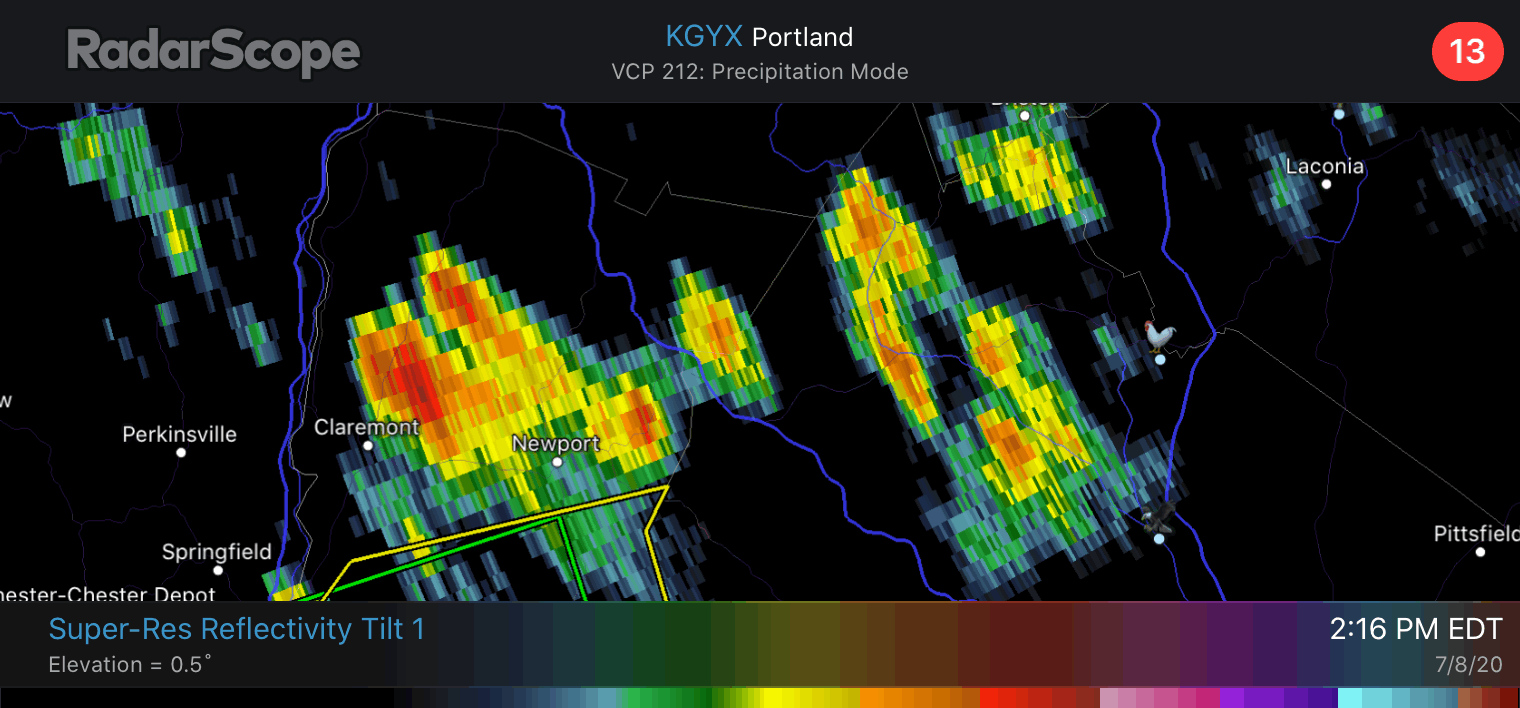
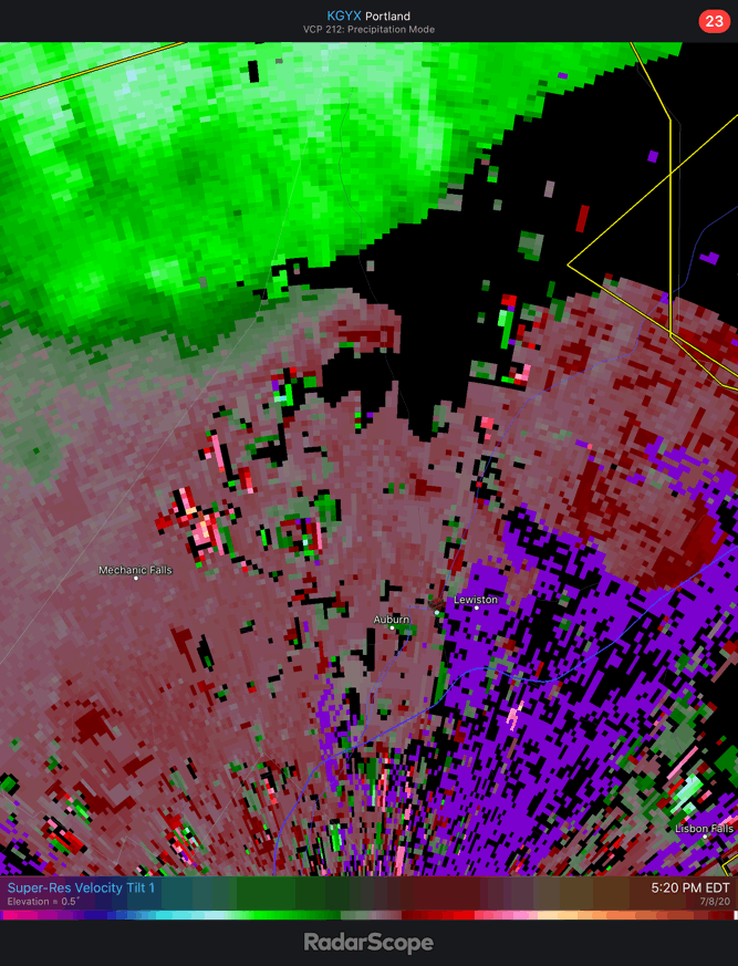
Yeah that really accelerated through LEW.
-
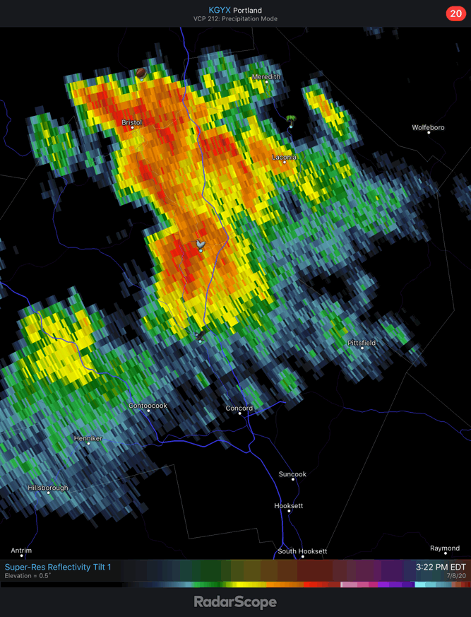
That was a quick 0.92”.
-
Looking active W of here

-
Droughtstein?
-
77/70 Not bothering me too much yet.
-
TS Fay - Drought ending Rains and Severe Convection
dendrite replied to weatherwiz's topic in New England
Strongest UVVs are in summer. -
Yeah I like being on the NE corner of that heat dome. Keep the 594-600dm garbage in the OH valley and Mid Atl.