-
Posts
73,952 -
Joined
Content Type
Profiles
Blogs
Forums
American Weather
Media Demo
Store
Gallery
Everything posted by dendrite
-
Dude is ACATT
-
Fastest thread cancel ever?
-
Good run. Don’t need a 50/50 snow to rainer here. Coat it up and dew it away.
-
NYC has had 2 daily mins colder than my coldest temp this winter. lol
-
That’s a Friday the 13th commute from hell
-
Down to 16.7°. Frigid for this winter!
-
Crushed.
-
Yeah thought I had the wrong maps when toggling back and forth.
-
Congrats of the weenie norlun.
-
GFS loses the Wed clipper
-
25 years ago we were encased up here.
-
GFS trolling taunton with 1-2ft in the mtns.
-
Doesn’t even get above freezing here. Thump of snow to IP/ZR.
-
At least it lasted longer than everyone here.
-
-
Sending out an SOS
-
It could be worse. I’m trapped under an inversion and someone’s wood stove (I assume) is bringing huge plumes of smoke this way. It’s blocking the sun and keeping it from mixing out. I’ve hit an AQI of 167 already. I feel like I’m in Donora PA out there shoveling.
-
The pattern is getting to some.
-
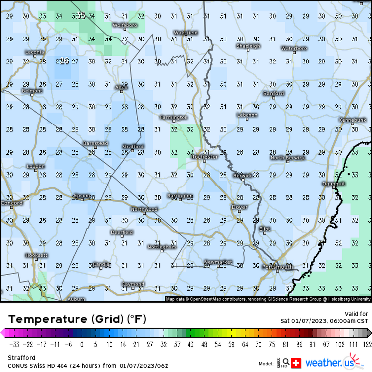
They were a little too low, but that sub 25° was for the rad pit in CON. When you look at the gfs gridpoint numbers it was about 28° around DAW, but some of that may be resolution related. The Swiss nailed it though. A little heat island around DAW with upper 20s around the area.
-
Well I’ve already used it once. Shoveled today though since I could get down close to the dirt so it can melt and clear faster.
-
2.9” and that’s my final answer.
-
Lead me to the indifferent room.
- 203 replies
-
- 3
-

-
- ratter
- regression
-
(and 1 more)
Tagged with:
-
It could be worse. You could be in Bozeman MT where they just pulled a -24/-45 day that was 54F below normal and then they had a couple of rain events a few days later. This F6 cracks me up whenever I see it. PRELIMINARY LOCAL CLIMATOLOGICAL DATA (WS FORM: F-6) STATION: BOZEMAN/GALLATIN FIELD MT MONTH: DECEMBER YEAR: 2022 LATITUDE: 45 46 N LONGITUDE: 111 9 W TEMPERATURE IN F: :PCPN: SNOW: WIND :SUNSHINE: SKY :PK WND ================================================================================ 1 2 3 4 5 6A 6B 7 8 9 10 11 12 13 14 15 16 17 18 12Z AVG MX 2MIN DY MAX MIN AVG DEP HDD CDD WTR SNW DPTH SPD SPD DIR MIN PSBL S-S WX SPD DR ================================================================================ 1 41 24 33 9 32 0 0.09 4.0 5 7.5 33 320 M M 8 12 43 320 2 26 2 14 -9 51 0 0.00 0.0 8 4.1 13 140 M M 4 16 160 3 21 -5 8 -15 57 0 0.00 0.0 8 4.8 10 180 M M 0 13 190 4 19 -10 5 -18 60 0 0.18 2.6 8 3.6 13 10 M M 5 128 14 360 5 35 13 24 2 41 0 0.13 1.4 12 6.9 21 230 M M 10 1 31 230 6 37 28 33 11 32 0 0.00 0.0 11 12.0 22 240 M M 9 29 230 7 33 0 17 -5 48 0 0.00 0.0 11 5.4 14 150 M M 1 16 140 8 18 -7 6 -16 59 0 T T 9 2.8 10 140 M M 0 18 11 10 9 31 -1 15 -6 50 0 T 0.3 9 4.2 13 80 M M 6 12 16 70 10 28 0 14 -7 51 0 0.00 0.0 8 3.3 12 160 M M 1 14 160 11 35 20 28 7 37 0 0.00 0.0 8 4.5 10 200 M M 6 14 220 12 28 13 21 0 44 0 0.01 0.3 8 5.7 13 290 M M 9 18 15 290 13 16 -4 6 -14 59 0 T 0.2 8 1.2 8 20 M M 8 18 10 20 14 22 8 15 -5 50 0 0.11 3.9 8 1.3 13 190 M M 10 128 13 180 15 22 7 15 -5 50 0 T 0.9 12 1.7 9 20 M M 10 128 11 20 16 22 0 11 -9 54 0 T T 12 2.3 9 350 M M 7 1 11 280 17 21 -3 9 -11 56 0 0.00 0.0 11 3.2 9 140 M M 4 1 11 150 18 8 -18 -5 -25 70 0 0.00 0.0 11 2.4 8 200 M M 1 18 11 140 19 -2 -20 -11 -31 76 0 T T 11 3.2 10 170 M M 3 18 12 170 20 5 -9 -2 -22 67 0 0.00 0.0 10 2.5 12 290 M M 6 14 290 21 5 -34 -14 -34 79 0 T M 14 9.7 21 190 M M 8 18 27 200 22 -24 -45 -34 -54 99 0 0.01 T 12 2.2 9 190 M M 4 128 10 190 23 8 -31 -11 -31 76 0 T M 12 0.7 7 70 M M 9 18 8 70 24 37 8 23 3 42 0 T M 12 3.2 13 140 M M 7 15 350 25 48 33 41 21 24 0 0.03 0.0 11 6.5 18 240 M M 9 23 230 26 48 27 38 18 27 0 0.00 0.0 9 4.3 14 220 M M 5 12 19 220 27 50 31 41 21 24 0 0.12 0.0 7 9.0 48 280 M M 7 1 67 290 28 41 27 34 14 31 0 0.00 0.0 6 9.8 22 230 M M 10 34 240 29 35 9 22 2 43 0 0.00 0.0 5 5.0 14 40 M M 5 17 40 30 40 11 26 6 39 0 0.00 0.0 5 5.5 16 230 M M 7 22 230 31 37 13 25 5 40 0 0.06 0.5 6 4.0 10 130 M M 9 1 13 310 ================================================================================ SM 791 87 1568 0 0.74 14.1 142.5 M 188 ================================================================================ AV 25.5 2.8 4.6 FASTST M M 6 MAX(MPH) MISC ----> 48 280 67 290
-
Benchmark where?
-
What you do is you click the link in his sig. lol


