dendrite
-
Posts
75,073 -
Joined
Content Type
Profiles
Blogs
Forums
American Weather
Media Demo
Store
Gallery
Everything posted by dendrite
-

July has arrived ... the Meteorologically defined mid summer month
dendrite replied to Typhoon Tip's topic in New England
BOX put it in the grids.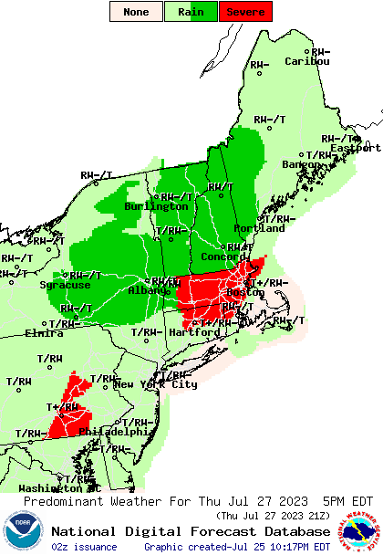
-
July has arrived ... the Meteorologically defined mid summer month
dendrite replied to Typhoon Tip's topic in New England
I had 0.00” and my ground is still damp. -
July has arrived ... the Meteorologically defined mid summer month
dendrite replied to Typhoon Tip's topic in New England
Bummer. Too bad you have a reasonable amount of appreciable rain while everyone else is flooding. -
July has arrived ... the Meteorologically defined mid summer month
dendrite replied to Typhoon Tip's topic in New England
Or not. I thought you would train a bit more. -
July has arrived ... the Meteorologically defined mid summer month
dendrite replied to Typhoon Tip's topic in New England
You’re going to get drenched -
The 2023 Lawn, Garden, Landscape Party Discussion
dendrite replied to Damage In Tolland's topic in New England
What a cutie. I would be planting it something more healthy like kale or salad greens. Maybe if you let that clover go it would leave your other plants alone. lol -
July has arrived ... the Meteorologically defined mid summer month
dendrite replied to Typhoon Tip's topic in New England
Huh? -
July has arrived ... the Meteorologically defined mid summer month
dendrite replied to Typhoon Tip's topic in New England
GFS is delayed but not denied. The euro was a nice dew breaker as well. -
July has arrived ... the Meteorologically defined mid summer month
dendrite replied to Typhoon Tip's topic in New England
All I've got on the old years is this... -
July has arrived ... the Meteorologically defined mid summer month
dendrite replied to Typhoon Tip's topic in New England
BWI -
July has arrived ... the Meteorologically defined mid summer month
dendrite replied to Typhoon Tip's topic in New England
DMH was a trash station for years. -
July has arrived ... the Meteorologically defined mid summer month
dendrite replied to Typhoon Tip's topic in New England
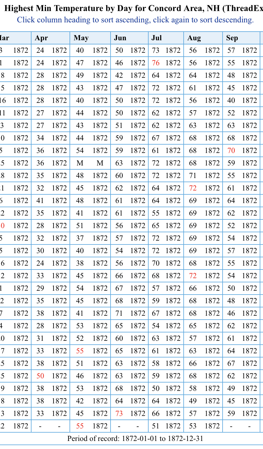
15 mins of 70+ in 1872. People would be losing their mind if this happened today. Comparatively BOS only had 8. So definitely put an asterisk next to some of that yore data.
-
July has arrived ... the Meteorologically defined mid summer month
dendrite replied to Typhoon Tip's topic in New England
My guess is some yore instrumentation, siting, or obs methods. The 1870s data for CON seems a little sketchy to me. 1938 though! -
I93 up here looking like 84 in Tolland this afternoon. Hopefully Scoot wasn’t in that traffic.
-
July has arrived ... the Meteorologically defined mid summer month
dendrite replied to Typhoon Tip's topic in New England
Looks like the >60 streak was a record at CON.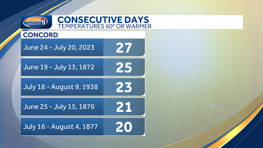
-
July has arrived ... the Meteorologically defined mid summer month
dendrite replied to Typhoon Tip's topic in New England
Euro laughing at the gfs cool down. -
July has arrived ... the Meteorologically defined mid summer month
dendrite replied to Typhoon Tip's topic in New England
For the confused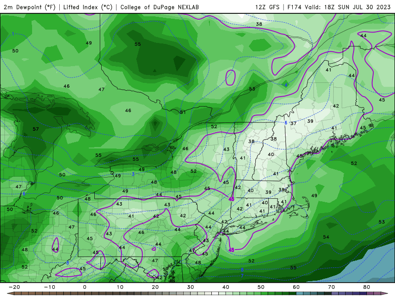
-
July has arrived ... the Meteorologically defined mid summer month
dendrite replied to Typhoon Tip's topic in New England
Goofus is really 1 hot day and then mulitple COC shots -
July has arrived ... the Meteorologically defined mid summer month
dendrite replied to Typhoon Tip's topic in New England
57.2° -
July has arrived ... the Meteorologically defined mid summer month
dendrite replied to Typhoon Tip's topic in New England
Already 63F...wtf. I want my super torchy mins back. -
July has arrived ... the Meteorologically defined mid summer month
dendrite replied to Typhoon Tip's topic in New England
Surely he’s just trolling us back now? At least I hope he is. We deserve it. -
July has arrived ... the Meteorologically defined mid summer month
dendrite replied to Typhoon Tip's topic in New England
I can picture him waking up in the middle of the night sweating and worrying about potted begonias in Wichita. -
July has arrived ... the Meteorologically defined mid summer month
dendrite replied to Typhoon Tip's topic in New England
Toss those temps for now. Looks like the GFS is overmixing at times again. It drops those dews in that 95-100 zone while keeping them up in NNE. -
July has arrived ... the Meteorologically defined mid summer month
dendrite replied to Typhoon Tip's topic in New England
Looks like ISP from years back when they had a foot of rain in one morning. -
July has arrived ... the Meteorologically defined mid summer month
dendrite replied to Typhoon Tip's topic in New England
“Only” 0.71” yesterday. The water table is back to the surface, but thankfully none of those insane totals south and west of here. We lush.