dendrite
-
Posts
75,095 -
Joined
Content Type
Profiles
Blogs
Forums
American Weather
Media Demo
Store
Gallery
Everything posted by dendrite
-
Hoodies for everyone this evening. Enjoy.
-
Probably delayed but not denied, but it's been getting pushed back.
-
-
I think I had cooler xmas eves in Naples
-
Our Dunkin got pumpkin spice in yesterday. 7/31 is a new record. Back broken.
-
Looks like 35/36 at SLK. 52.3° here. Nice morning.
-

July has arrived ... the Meteorologically defined mid summer month
dendrite replied to Typhoon Tip's topic in New England
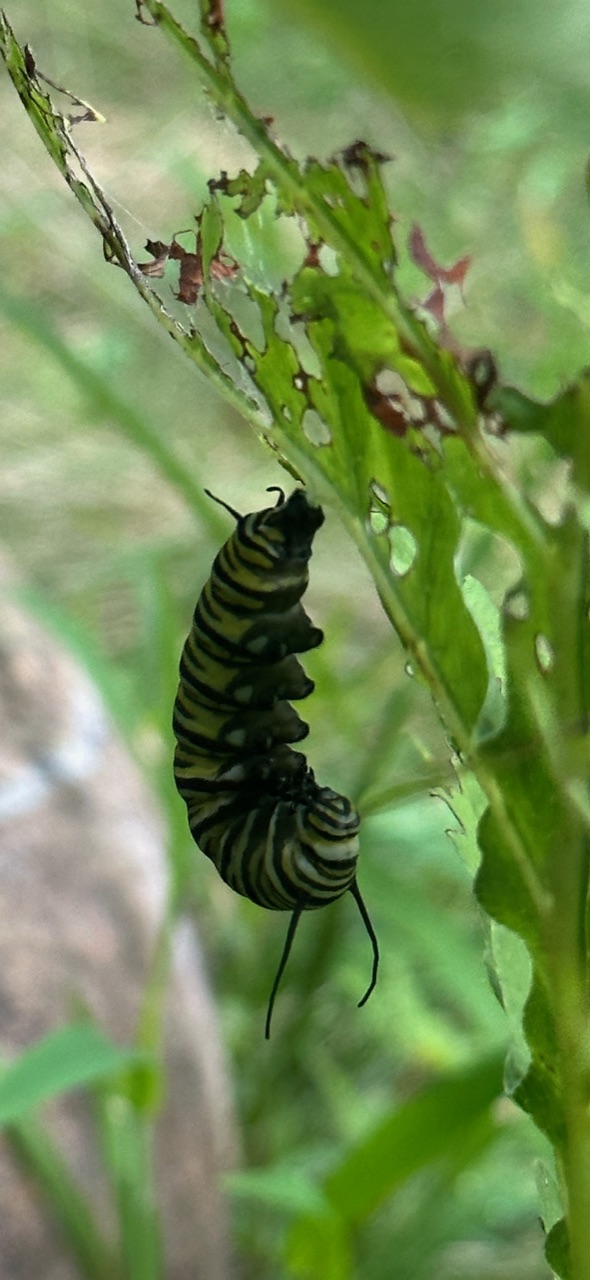
Fyi…pupa incoming
-
July has arrived ... the Meteorologically defined mid summer month
dendrite replied to Typhoon Tip's topic in New England
Not going to get into thermodynamic semantics with you, but if we’re going to have a top 5 warm July I’d like it to come with more sun and some 95+ readings. The most interesting thing about this month was the rain. A bunch of lows in the 60s doesn’t really move my needle. Congrats everyone on all of the joules though. -
So when is the swelling, rash, and pain supposed to subside?
-
July has arrived ... the Meteorologically defined mid summer month
dendrite replied to Typhoon Tip's topic in New England
CON will finish 83.8 (+0.8) / 62.8 (+3.6) Definitely a meh way to get there…especially with all of the clouds and rain. But that’s pretty much the new normal with the torching arctic and the inability to get real fronts down here in the peak of summer. -
There's lots of absolutes in this thread. In reality I like both, but I feel more alive during the warm season. Of course every season has its pros and cons and we all weigh the variables differently. I just find winter to linger too long as I age and we don't get many breaks up here like the SNEers get. While Ginxy, DIT, and Scoot are popping a 65F warm sector in Jan I'm usually 34F with 1/4sm fog. The darkness is pretty relentless up here Nov-Apr. The chickens are a lot easier to tend in the warm season and I've really gotten into the orcharding the last 5 years too. I grew up obsessed with snow, but don't care about it as much as I get older. I think we all love a good storm, but most of the events are just a PITA. Just give me enough to keep the ground insulated from the brutal cold and I'm good.
-
You really need to be near the ocean if you're in the deep south. I loved 93/75 with an ocean breeze at APF...93/75 at GNV was a different story.
-
July has arrived ... the Meteorologically defined mid summer month
dendrite replied to Typhoon Tip's topic in New England
52.4° with occasional fog. B2B 52s. Rock lobster. -
July has arrived ... the Meteorologically defined mid summer month
dendrite replied to Typhoon Tip's topic in New England
He would’ve had a freeze if he was there in 2001. -
July has arrived ... the Meteorologically defined mid summer month
dendrite replied to Typhoon Tip's topic in New England
That’s a range for the month of over 30° in July. Good luck ever seeing that again in our lifetimes. -
July has arrived ... the Meteorologically defined mid summer month
dendrite replied to Typhoon Tip's topic in New England
We’re all excited for lows under 60° and this was July of 1965 at CON. lol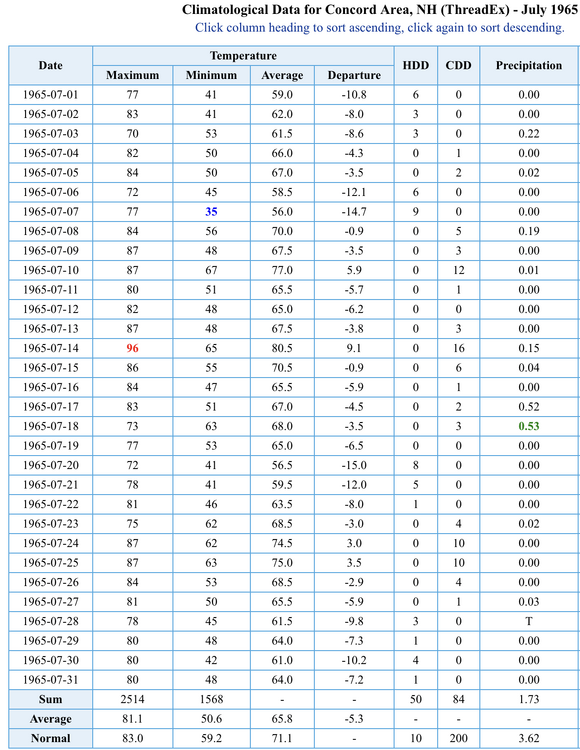
-
July has arrived ... the Meteorologically defined mid summer month
dendrite replied to Typhoon Tip's topic in New England
Nah we’re not getting below 52° by midnight. -
July has arrived ... the Meteorologically defined mid summer month
dendrite replied to Typhoon Tip's topic in New England
High of 72°. Nice breeze. Ended up with 3 HDD out of the day. -
It’s right over my septic so I’d rather not. I haven’t risked going back to get the mower yet either. I think I’ll cover up head to toe and put a mesh bug hat on as well. Little bastards.
-
Just ran over a yellow jacket nest while mowing. Got stung multiple times. I should’ve known because the ground sank in on one pass and then in the same spot on the return was when I got attacked. It must be a massive nest.
-
July has arrived ... the Meteorologically defined mid summer month
dendrite replied to Typhoon Tip's topic in New England

-
July has arrived ... the Meteorologically defined mid summer month
dendrite replied to Typhoon Tip's topic in New England
Since 6/1 is a hoot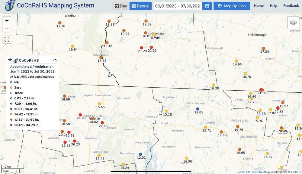
-
July has arrived ... the Meteorologically defined mid summer month
dendrite replied to Typhoon Tip's topic in New England
The heat is relative. 93 here is big and that’s pushing 98 CON-MHT-ASH. My point is we haven’t had that yet, and most of the heat we did have was earlier in the season with only modest dews. Like Tippy has said, we haven’t had anything highly anomalous like the rest of the country has seen so far. -
July has arrived ... the Meteorologically defined mid summer month
dendrite replied to Typhoon Tip's topic in New England
That’s like saying we’re over the hump with winter on 1/30. Some winters are just starting around then…lol. There’s still a lot of summer to go. We haven’t had a brutal heat day yet either. -
Yeah GEFS and EPS are still both retrograding the WAR in by 8/10. Enjoy the next week, but plan on a dog day stretch returning.