dendrite
-
Posts
67,800 -
Joined
Content Type
Profiles
Blogs
Forums
American Weather
Media Demo
Store
Gallery
Everything posted by dendrite
-

August Disco 2021. Do record dews continue?
dendrite replied to Damage In Tolland's topic in New England
Maybe the torchmac at BDL can flirt with u70s/80F on Sunday, but it'll be COC. No 80s at 1kft. -
August Disco 2021. Do record dews continue?
dendrite replied to Damage In Tolland's topic in New England
EPS looks real torchy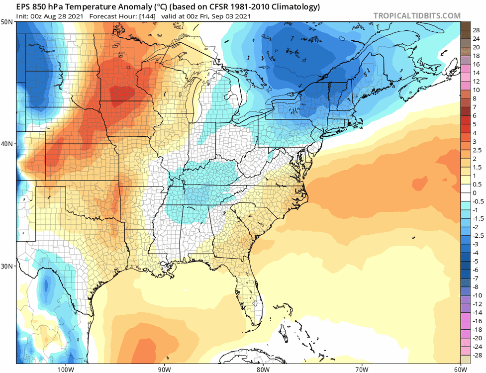
-
August Disco 2021. Do record dews continue?
dendrite replied to Damage In Tolland's topic in New England
60° is a weak threshold. We had a lot of 60-65° rain in July. 62/62 is more raw than muggy. I prefer the 65+ and 70+. -
How many gallons is your well? I think I’ve read 1gal/200gal and to dilute it with water before pouring it in to avoid any possible pipe corrosion.
-
August Disco 2021. Do record dews continue?
dendrite replied to Damage In Tolland's topic in New England
Good luck
-
August Disco 2021. Do record dews continue?
dendrite replied to Damage In Tolland's topic in New England
80ish next weekend based on what guidance? -
August Disco 2021. Do record dews continue?
dendrite replied to Damage In Tolland's topic in New England
Euro is one hot day. In and out...NBD. -
August Disco 2021. Do record dews continue?
dendrite replied to Damage In Tolland's topic in New England
MHT shot up when the front went through. Dew caved and temp jumped. 91/62 82° for the chooks right now -
August Disco 2021. Do record dews continue?
dendrite replied to Damage In Tolland's topic in New England
I appreciate the out-of-staters since without the lake and their $$$ my region would be a desolate wasteland. But around this time of year I start looking forward to the reduced traffic on 93 on Fridays/Sundays. -
August Disco 2021. Do record dews continue?
dendrite replied to Damage In Tolland's topic in New England
I'm not really ready for summer to end. I'd like 75-80F right into November. I'm just done with the dews...I've been struggling breathing through my nose and think I have a deviated septum. Time to dry it out. -
August Disco 2021. Do record dews continue?
dendrite replied to Damage In Tolland's topic in New England
Gotta get the Massholes out of the Lakes Region so our numbers can start going down. -
My lawn is probably < 50% grass.
-
August Disco 2021. Do record dews continue?
dendrite replied to Damage In Tolland's topic in New England
Monday will be hot...may linger into Tuesday especially for SNE. But otherwise it's in and out up here. Those GFS runs have been drunk lately in the extended. -
August Disco 2021. Do record dews continue?
dendrite replied to Damage In Tolland's topic in New England
Times they are a-changin' And yeah, toss that ASH dew and no one dare argue with me about that again. -
August Disco 2021. Do record dews continue?
dendrite replied to Damage In Tolland's topic in New England
Had some close ones here this afternoon despite missing the cells to the north...gotta watch those anvils for +CGs. -
August Disco 2021. Do record dews continue?
dendrite replied to Damage In Tolland's topic in New England
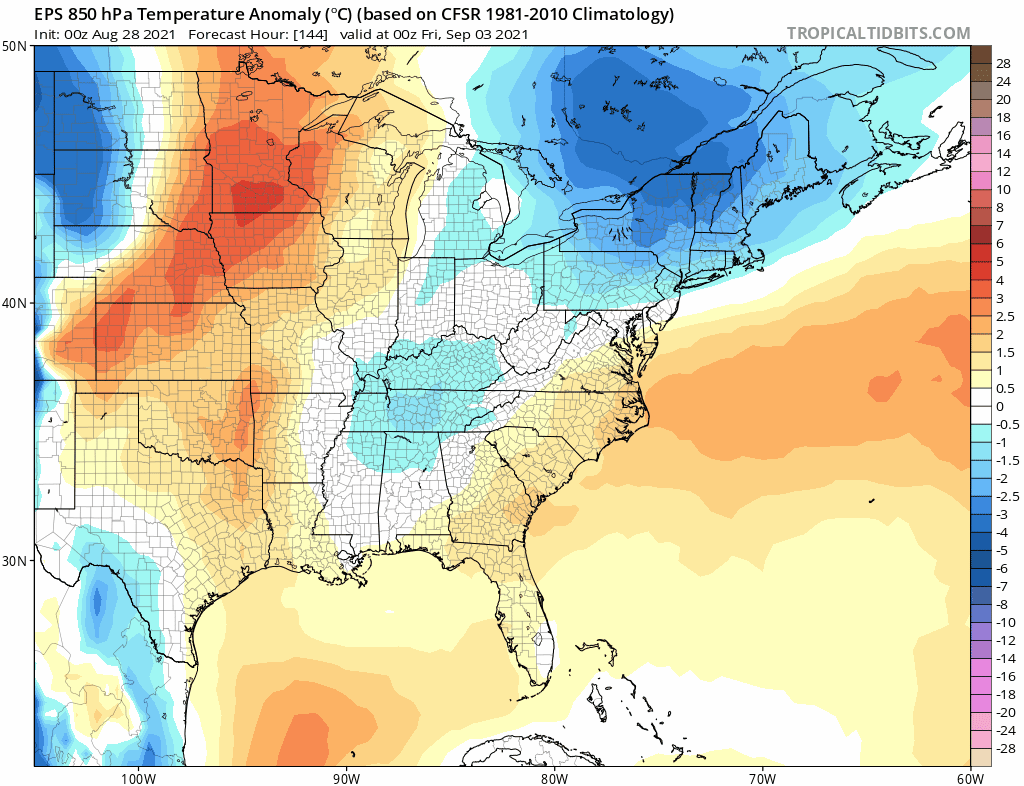
850-925 temps were warm up here.
-
August Disco 2021. Do record dews continue?
dendrite replied to Damage In Tolland's topic in New England
I mean maybe we get another day or two of excessive heat later in September, but yeah, I think I’m done with the 90/70 nonsense here. -
August Disco 2021. Do record dews continue?
dendrite replied to Damage In Tolland's topic in New England
Hit 90 here. Glad we’re done with this. 79/73 now. Dews should start dropping here overnight. Should be a beaut for NNE tomorrow, -
August Disco 2021. Do record dews continue?
dendrite replied to Damage In Tolland's topic in New England
That was an emphatic quick end of summer on that run. Too bad it's the op gfs. -
August Disco 2021. Do record dews continue?
dendrite replied to Damage In Tolland's topic in New England
Jesus....GFS drops the full arctic in for over a week. -
August Disco 2021. Do record dews continue?
dendrite replied to Damage In Tolland's topic in New England
88/73 hottest heat index in awhile -
Well I did say a brake caliper maybe not disengaging. Parking brake isn't exactly an Occam's razor possibility. I couldn't tell you the last time I used an E brake. Probably way over a decade. My wife never used hers on her old Saturn and one time when she went to get it inspected they told her it had rusted out and froze in place and it had to be replaced to be passed. It wasn't cheap and that was like a decade ago.
-
August Disco 2021. Do record dews continue?
dendrite replied to Damage In Tolland's topic in New England
Not gonna lie. I like my pool water 85F+. -
August Disco 2021. Do record dews continue?
dendrite replied to Damage In Tolland's topic in New England
I don’t recall anyone saying that either. -
August Disco 2021. Do record dews continue?
dendrite replied to Damage In Tolland's topic in New England
I’m on the prolonged uber dews being done after this week. We shall see. Still plenty of warmth and dews to go for classrooms.