dendrite
-
Posts
75,088 -
Joined
Content Type
Profiles
Blogs
Forums
American Weather
Media Demo
Store
Gallery
Everything posted by dendrite
-
Not sure. I have the same thing going on with one of my huge ones and I've never seen it previously.
-

Octorcher or Roctober 2023 Discussion Thread
dendrite replied to Damage In Tolland's topic in New England
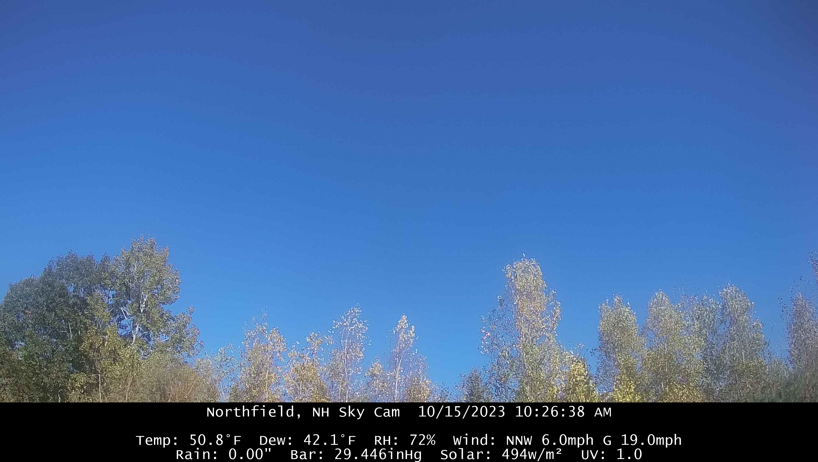
Beautiful sunny morning.
-
Octorcher or Roctober 2023 Discussion Thread
dendrite replied to Damage In Tolland's topic in New England
While visiting the wife in Uganda to chase snow in their highest peaks -
Octorcher or Roctober 2023 Discussion Thread
dendrite replied to Damage In Tolland's topic in New England
You can almost envision a few light frosts this winter and then we go right into Morch. -
Octorcher or Roctober 2023 Discussion Thread
dendrite replied to Damage In Tolland's topic in New England
Clear that search history before Alison sees it. lol -
Octorcher or Roctober 2023 Discussion Thread
dendrite replied to Damage In Tolland's topic in New England
Was this selfie right before your duet of Islands in the Stream?
-
Octorcher or Roctober 2023 Discussion Thread
dendrite replied to Damage In Tolland's topic in New England
I don’t have fruit yet on my trees, but I have fruiting buds setting for the first time this year so hopefully I get some flowers and fruit next year. I fellow grower in IL has sent me some in the past so I’ve gotten to try a bunch of varieties. I don’t think I’d freeze them because I’ve seen many people get upset stomachs from eating saved, frozen pulp. I’d probably eat some fresh, sell some, make iced cream, and offer some to the local brewery and let them experiment with a pawpaw beer.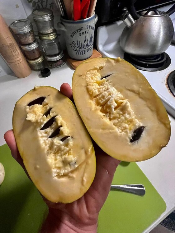
-
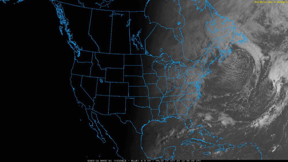
Nice look of the annular solar eclipse on vis today.
-
Octorcher or Roctober 2023 Discussion Thread
dendrite replied to Damage In Tolland's topic in New England
Like pawpaw? It’s a very tropical taste. Kinda like cherimoya, but many haven’t tasted that either. The selectively bred cultivars are generally sweet with varying intensity of pawpaw taste with a hint of other flavors with it. Some have a hint of banana, mango, melon, vanilla, coconut, or pineapple. When ripe, most have a custardy texture although there are a couple that are more firm like a marshmallow. The wild ones are full of seeds, less sweet, and tend to have a bad aftertaste. If anyone is near RI they may still have some available at Rocky Point Farm in Warwick Monday night, but check their FB first. Then tend to have a line and sell out in 10 minutes when they go on sale. -
Octorcher or Roctober 2023 Discussion Thread
dendrite replied to Damage In Tolland's topic in New England
I don’t think I’ve ever seen anyone more triggered by a topic in here than wolfie with cc. -
Octorcher or Roctober 2023 Discussion Thread
dendrite replied to Damage In Tolland's topic in New England
My pawpaw grove is loving the climate change. The more we can keep pushing back that avg first freeze the more ripe fruit I’ll get. -
Octorcher or Roctober 2023 Discussion Thread
dendrite replied to Damage In Tolland's topic in New England
Beer? I don’t think anyone here is kept up at night worrying about the warming climate. But what’s the problem with discussing possible scenarios and outcomes? If you don’t like it skip over the posts. -
Octorcher or Roctober 2023 Discussion Thread
dendrite replied to Damage In Tolland's topic in New England

-
Octorcher or Roctober 2023 Discussion Thread
dendrite replied to Damage In Tolland's topic in New England
Windows open? Don’t you have a newer house? -
Octorcher or Roctober 2023 Discussion Thread
dendrite replied to Damage In Tolland's topic in New England
Outside shot at my first November first freeze ever. CON has never made it out of October without a freeze either although I’m sure they’ll sneak one in. -
Does your stove manufacturer recommend hardwood or softwood?
-
Octorcher or Roctober 2023 Discussion Thread
dendrite replied to Damage In Tolland's topic in New England
Seems like it was around. https://old.reddit.com/r/etymology/comments/34mzsx/nsfw_did_the_movie_american_pie_coin_the_term/cqwdhwq/ -
Octorcher or Roctober 2023 Discussion Thread
dendrite replied to Damage In Tolland's topic in New England
CON 34° but I didn’t notice any frost around the area. -
Octorcher or Roctober 2023 Discussion Thread
dendrite replied to Damage In Tolland's topic in New England
38.8° with some clouds and fog. Maybe a 35° for CON. Bear Brook RAWS site is 33°. NBD really but still looking for that first freeze in the extended. -
Octorcher or Roctober 2023 Discussion Thread
dendrite replied to Damage In Tolland's topic in New England
We all still mowing. -
2 2nds and a player from Navy?
-
The post was sarcasm, but I don't disagree. There should be quite a few QB prospects entering this year that you should be able to get one with the trajectory you're on even if you trade down a bit. But our track record of drafting offensive talent has been terrible recently. Kick Trent to the curb and get a stud at LT first because any QB you bring in here is going to be running for his life with this line.
-
Octorcher or Roctober 2023 Discussion Thread
dendrite replied to Damage In Tolland's topic in New England
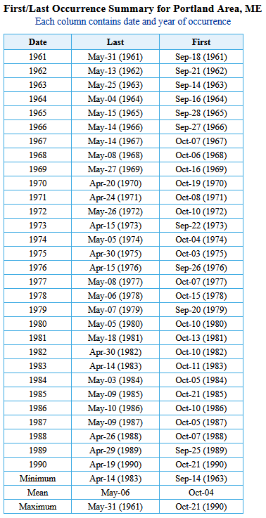
Plugging 1991-2020 into NOWdata gets Oct 11. 1961-1990 was a week earlier.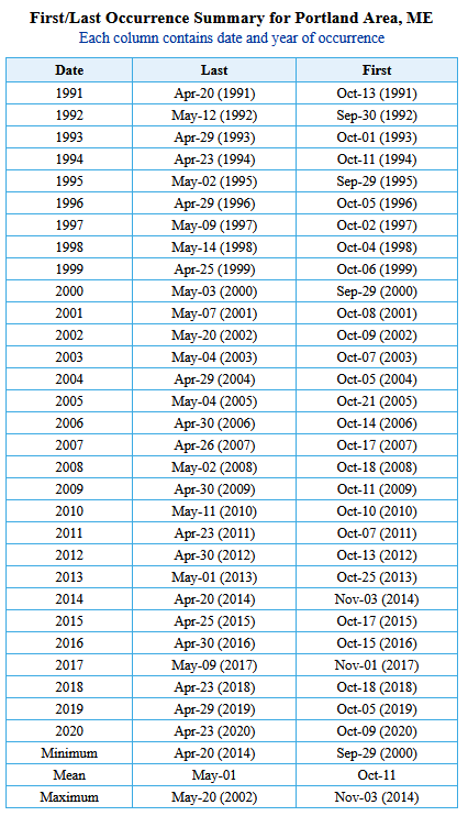
-
I can't wait to turn our high 1st into a low 1st and 2nd in 24 and another 1st in 25.
-
Octorcher or Roctober 2023 Discussion Thread
dendrite replied to Damage In Tolland's topic in New England
I’m not sure how much I trust a 110mph gust in 1804.