dendrite
-
Posts
75,090 -
Joined
Content Type
Profiles
Blogs
Forums
American Weather
Media Demo
Store
Gallery
Everything posted by dendrite
-

Octorcher or Roctober 2023 Discussion Thread
dendrite replied to Damage In Tolland's topic in New England
GFS has a little inversion there at 925. There will probably be some low to mid 70s mid to late week, but I’ll take the under on 80s. -
Octorcher or Roctober 2023 Discussion Thread
dendrite replied to Damage In Tolland's topic in New England
Yeah, the growing season will be coming to an end here about a week from now even if the airmass moderates quite a bit. -
Octorcher or Roctober 2023 Discussion Thread
dendrite replied to Damage In Tolland's topic in New England
The showers haven’t looked impressive here on radar, but man they have been brief soakers. Looks like the bodies are half submerged under 2.20” in S VT so far. -
Octorcher or Roctober 2023 Discussion Thread
dendrite replied to Damage In Tolland's topic in New England
Probably a sonic boom from a meteor -
Octorcher or Roctober 2023 Discussion Thread
dendrite replied to Damage In Tolland's topic in New England
degrees? -
Octorcher or Roctober 2023 Discussion Thread
dendrite replied to Damage In Tolland's topic in New England
Lots of lake effect rain for Houghton. -
Octorcher or Roctober 2023 Discussion Thread
dendrite replied to Damage In Tolland's topic in New England
-
Octorcher or Roctober 2023 Discussion Thread
dendrite replied to Damage In Tolland's topic in New England
That min was really anomalous like 1967. Needed that deep pack to pull that off.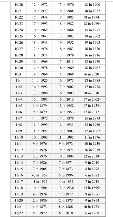
-
Octorcher or Roctober 2023 Discussion Thread
dendrite replied to Damage In Tolland's topic in New England
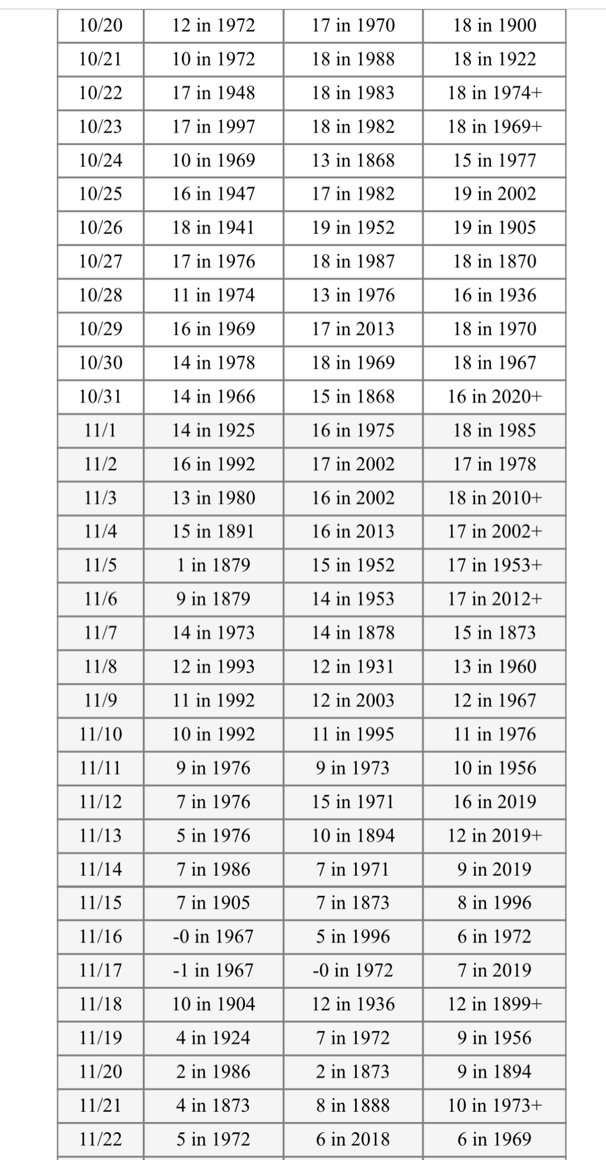
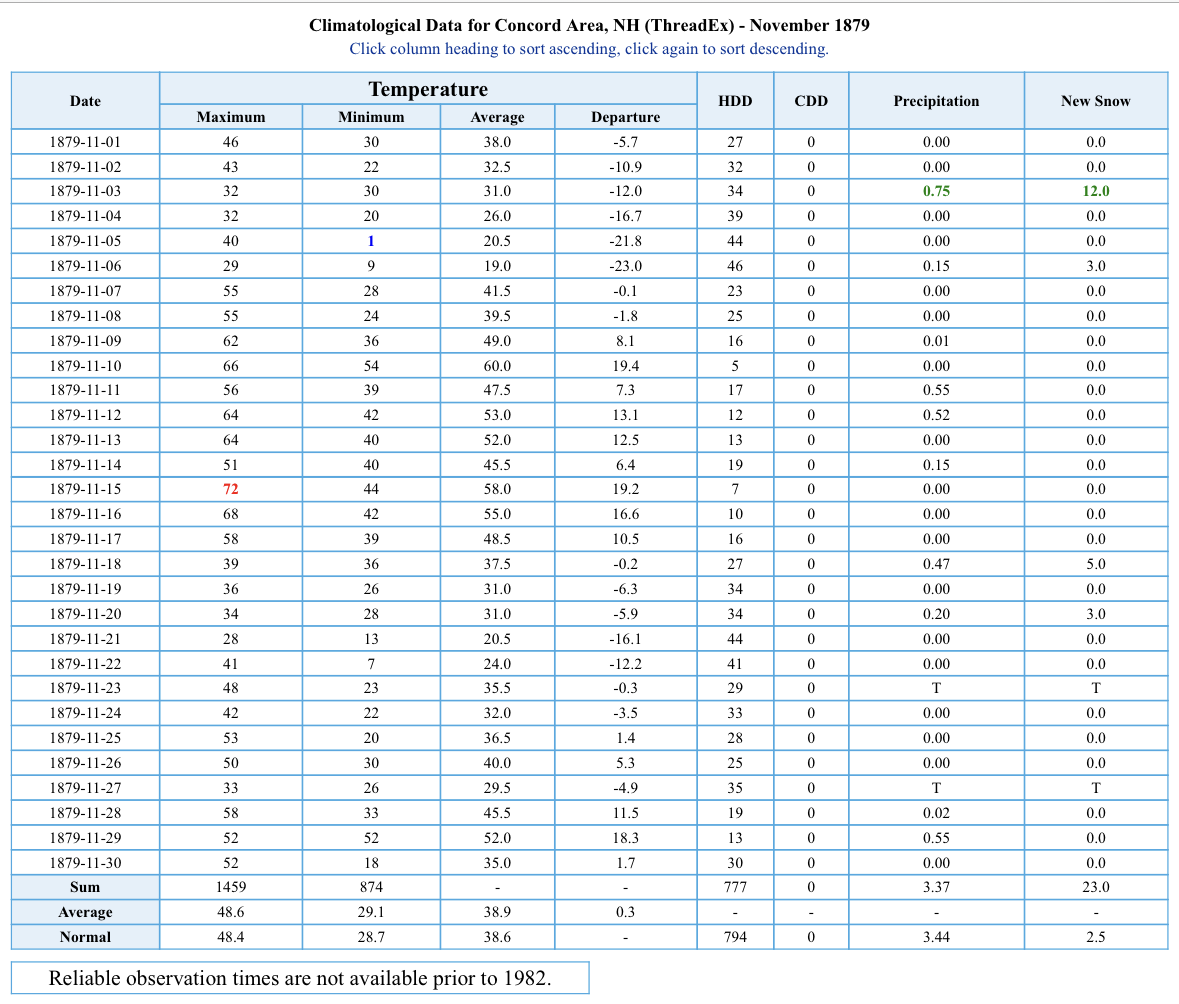
Novie 1879 was fun in CON…even with some rounded yore values. Around a foot on 11/3. 23” for the month and 4 events of 3”+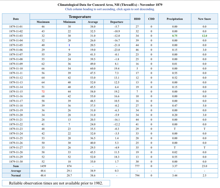
-
Octorcher or Roctober 2023 Discussion Thread
dendrite replied to Damage In Tolland's topic in New England
Lots of extra heat released by trick or treaters torching the BL? -
Octorcher or Roctober 2023 Discussion Thread
dendrite replied to Damage In Tolland's topic in New England
To be fair that all falls on 11/1 so it’s back on -
Octorcher or Roctober 2023 Discussion Thread
dendrite replied to Damage In Tolland's topic in New England
I see we’re starting clown season before we even hit freezing. -
Octorcher or Roctober 2023 Discussion Thread
dendrite replied to Damage In Tolland's topic in New England
-
Octorcher or Roctober 2023 Discussion Thread
dendrite replied to Damage In Tolland's topic in New England
Yeah looks like sensor issues based on the coop forms. -
Octorcher or Roctober 2023 Discussion Thread
dendrite replied to Damage In Tolland's topic in New England

-
Octorcher or Roctober 2023 Discussion Thread
dendrite replied to Damage In Tolland's topic in New England
MEX for BDL is 39°. A freeze will be tough. They’re already late and it’ll probably go until near Halloween. -
Octorcher or Roctober 2023 Discussion Thread
dendrite replied to Damage In Tolland's topic in New England
From 1935-1993 all of BDL’s first 41° or lower mins occurred in Aug or Sep. Now they go into Mid Oct no problem. -
Octorcher or Roctober 2023 Discussion Thread
dendrite replied to Damage In Tolland's topic in New England
Latest < 42° on record there was 10/13/2018. Shattered that. -
Octorcher or Roctober 2023 Discussion Thread
dendrite replied to Damage In Tolland's topic in New England
Toss that S. Lincoln too. -
Octorcher or Roctober 2023 Discussion Thread
dendrite replied to Damage In Tolland's topic in New England
That Northfield, VT record early freeze date looks bogus. There’s no way they pulled 32° on 8/21/2014.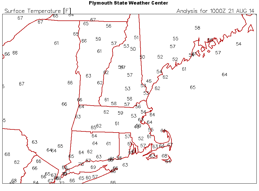
-
Octorcher or Roctober 2023 Discussion Thread
dendrite replied to Damage In Tolland's topic in New England
40.3° More days above 40° -
Octorcher or Roctober 2023 Discussion Thread
dendrite replied to Damage In Tolland's topic in New England
The early month heat was fairly impressive. -
Octorcher or Roctober 2023 Discussion Thread
dendrite replied to Damage In Tolland's topic in New England
idk...looks like the normal vis sat to me. Pretty cool how you can see the weak isolated convection (cumulus) dissipate the stratus field around them. Must be some weaker downdrafts around them that's clearing the thin low stratus out. It almost looks like that "hole punch" phenomenon but that requires ice crystals to rob the stratus of water vapor due to the vapor pressure differences. -
Octorcher or Roctober 2023 Discussion Thread
dendrite replied to Damage In Tolland's topic in New England
Can the banana in the run make it into Mowvember??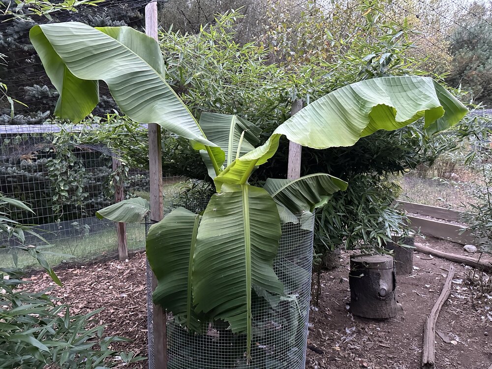
-
Octorcher or Roctober 2023 Discussion Thread
dendrite replied to Damage In Tolland's topic in New England
52 days until the sunsets start getting later. It’s hard to believe winter’s over before it even started, but here we are.