dendrite
-
Posts
75,095 -
Joined
Content Type
Profiles
Blogs
Forums
American Weather
Media Demo
Store
Gallery
Everything posted by dendrite
-
DIT not spamming his snow showers and missing out on the TV crews
-
I mean it’s not like it’s a major warm signal or anything. There’s still some neg anomalies to our north as well and we know how that can trend at the surface toward T-0.
-
What are they going to do to get you below freezing?
-
Ensembles look a little warmer overnight in the extended after a brief cool down with most of the cold staying to our west. Nothing too torchy…probably more of the same.
-
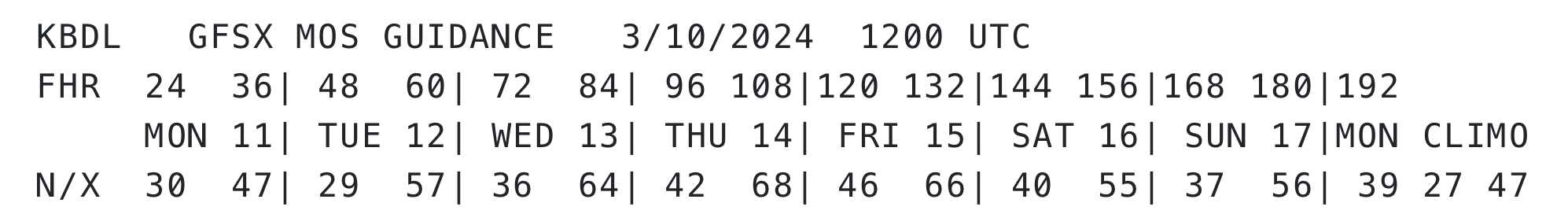
Just another typical March week at BDL
-
Silicone. What a bunch of dummies. Everyone knows you can get away with it by filling it with bird poop.
-
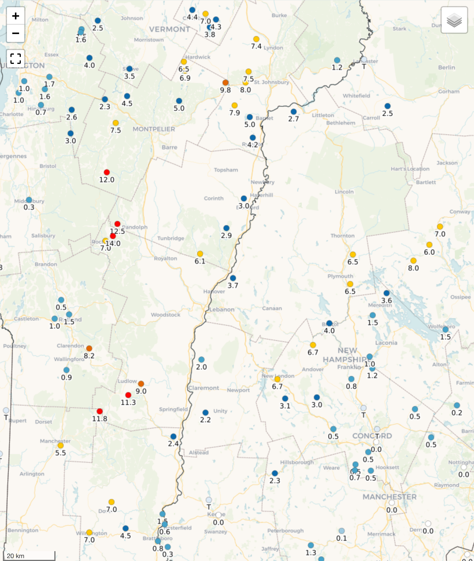
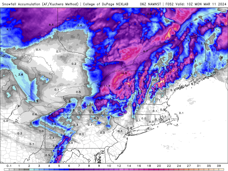
NH/VT totals

-
please come back soon
-
Looks like about 1.4” but what a mess out there. Pouring now and 34.5°. Water everywhere again.
-
32.5° SN 0.5” so far
-
Flipping back and forth now after a snow burst. Lots of sleet or refrozen flakes in there too. Just a sloppy coating so far. 33.0
-
All snow here now
-
34.4° -RA
-
Getting some sun now. Up to 40°.
-
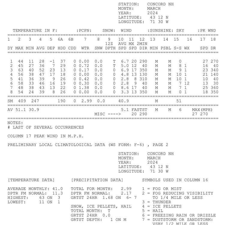
Typical +11.3 here so far
-
Yeah we need to keep normals in perspective. ORH has 4 70+ readings in their history through 3/14 and they’re all in the 2000s.
-
Won’t be much here and it has gotten warmer on guidance for late week…less marine taint. It’ll cool down beyond that, but we’ll revisit in a week to see just how much. A few days of NW flow with no pack or frost with a little BN 850s won’t result in that much cold east of the hills. I actually hope we get closer to normal because I have a lot of buds swelling and ready to open on my chestnuts.
-
Mid to late next week is looking warmer on guidance down there. No need to go out to d10-15.
-
Probably some resolution issues there with the gfs. 3k nam shows the elevation differences better
-
Euro AI 965 over BOS looks more ridiculous than Taylor Swift AI in Arrowhead.
-
Cadavers fully covered again
-
Eh. NAM and EC are fairly wintry here, but damn it is close.
-
Down to 29° Frigid!