

dendrite
-
Posts
66,943 -
Joined
Content Type
Profiles
Blogs
Forums
American Weather
Media Demo
Store
Gallery
Everything posted by dendrite
-
 I mean we’re getting to the point where the EPS doesn’t normally stray much from the op anyway.
 -
It’s the same thing as when you lived here. They’re whatever you want them to be.
-
I mean it’s not worth jumping off the Tobin over one 18z gfs run, but it’s leaving most of the southern s/w behind
-
It’s a different look in the upper levels. Apples to oranges
-
Just another possibility at this time range, but it goes to show you how a few subtle nuances in the flow can really affect things exponentially out in time.
-
Mostly northern stream this run. Still a big hit ENE. Back dat azz up.
-
Will lol if the goofus loses this to some extent
-
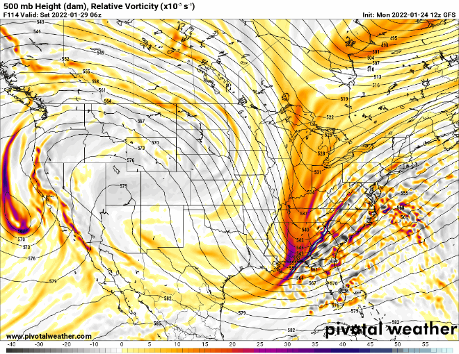
GFS is really carving the southern s/w deeper into the SW
-
idk...I feel like the lows that really go bonkers with the bombogenesis do it sooner than progged. That's all empirical from me though.
-
Everything is shifted west a bit...even the western (stronger) ridge axis this run. That late northern s/w looks potent.
-
The chickens are more agitated than normal. I think they sense something.
-
This run is gonna have a shot...
-
Anyway, hopefully the goofus is as exciting as that game.
-
Everyone should get a shot at a foot.
-
The zero blitz was over aggressive. There’s still plenty of defense played…even in the games this weekend.
-
Change it to each team has a chance and then you’ll get games where both teams score a TD, and then the team that scored first will score again. Then that will be considered unfair since the other team doesn’t get 2 shots. I mean where does it end?
-
Coin flip doesn’t decide the game…just who gets the ball first. If you can’t keep the offense from going 80 yards then tough cookies.
-
Please no. Don’t want the gimmicky college rules in the NFL. The NFL doesn’t really want long overtimes due to player safety. They’ve already reduced it to 10 mins in the reg season. The D coordinators need to keep playing aggressive and not slip into scared prevent mode.
-
Doesn’t really matter to me, but maybe someone should play some defense and get a stop…heck, even bend but don’t break works.
-
13 seconds is the new wide right.
-
Nope…doesn’t work that way. Lower res means fewer data points, different values, and different calculations. Plus you have chaos with the difference in rounding of values.
-
The control is just a lower res version of the op. The ens members are perturbed from that.


