dendrite
-
Posts
67,071 -
Joined
Content Type
Profiles
Blogs
Forums
American Weather
Media Demo
Store
Gallery
Everything posted by dendrite
-
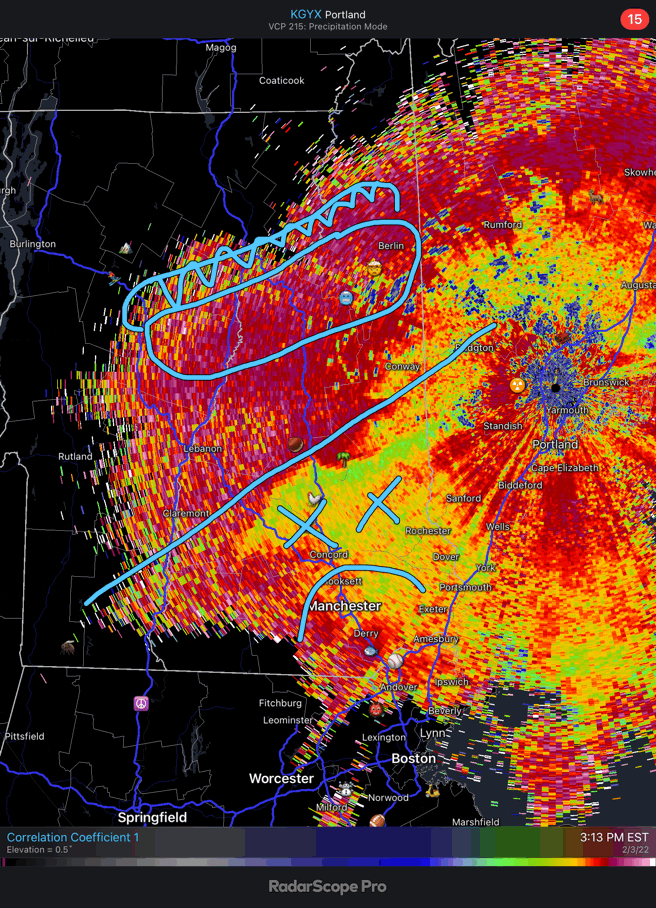
Decent push northward of low cc on ENX in the last half hour
-
It was more a product of poor resolution in the models. They used to love showing light QPF on the back side of lows when the grid spacing was large. In reality the QPF was more for upslope locations with only flurries SE of there.
-
-
Almost need a summer and winter version. Then you could just add flash freeze.
-
Hopefully it just stays mostly rain at this point. I can actually see parts of the driveway again. I don’t need it covered back up with 2” of sleet.
-
Hit 44F but down to 39F with -SHRA
-
Just going by the ptype maps and the fact there's a slight lag...at least versus 00z.
-
Euro another tick warmer in the midlvls.
-
It could get warmer from there with weak WAA ahead of the low…midlevels that is
-
I can, but it’s been awhile.
-
I mean that’s snow, but I don’t believe it.
-
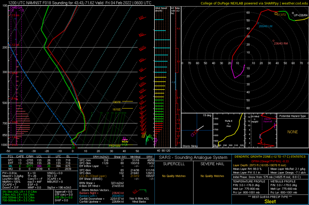
Man I hate this model Date: 18 hour GFS valid 6Z FRI 4 FEB 22 Station: 43.43,-71.62 Latitude: 43.43 Longitude: -71.62 ------------------------------------------------------------------------------- LEV PRES HGHT TEMP DEWP RH DD WETB DIR SPD THETA THE-V THE-W THE-E W mb m C C % C C deg knt K K K K g/kg ------------------------------------------------------------------------------- 0 1000 151 SFC 986 267 -1.4 -1.8 97 0.4 -1.6 11 5 272.9 273.4 272.3 282.1 3.40 2 950 559 -3.2 -3.3 99 0.2 -3.3 35 14 274.0 274.5 272.6 282.5 3.14 3 900 986 -3.3 -3.4 99 0.1 -3.3 77 19 278.1 278.7 275.3 287.3 3.31 4 850 1441 -1.0 -1.1 99 0.1 -1.0 172 18 285.1 285.8 279.9 296.8 4.15 5 800 1926 -0.1 -0.2 100 0.1 -0.1 213 51 291.1 291.9 283.3 304.7 4.73 6 750 2444 0.1 0.1 100 0.0 0.1 218 72 296.7 297.6 285.9 311.8 5.13 7 700 2995 -1.8 -1.9 99 0.1 -1.9 224 77 300.5 301.4 287.0 314.8 4.74 8 650 3582 -4.6 -4.9 98 0.3 -4.7 230 79 303.8 304.5 287.5 316.3 4.09 9 600 4209 -7.5 -7.9 97 0.4 -7.7 239 82 307.4 308.0 288.2 318.4 3.51 10 550 4883 -11.0 -11.5 96 0.5 -11.2 246 77 311.1 311.6 288.8 320.3 2.89 11 500 5610 -14.8 -15.2 97 0.4 -14.9 241 76 315.0 315.4 289.6 322.7 2.35
-
GFS trimming back the southern edge again, but still barely dumps here.
-
The truck was quite toasty yesterday afternoon.
-
Not weird at all. The low is approaching. We get a weak cold press ahead of it, then a bump back north as the low approaches, and then the CAA kicks in for good on the back side.
-
Toss the HRRR with the GFS right into the trash. Don't even bother trying to compost.
-
Are you trying to make Kevin leave the board again?
-
lol..no. 3k is a tick colder than 12k.
-
-
3k is interesting here beginning 6z tonight.
-
Warmer here
-
The problem is the midlevel press is still from the NW. 750mb dgiaf about the NE ageo flow.
-
That makes me ragey.
-
I could see the sfc verifying cooler, but I think the nam wins the mid level warmth. So I’m tossing the gfs. We’ll get the typical slow transition of RA to FZRA to PL to SN. Maybe 2-4” of frozen glop while Gene pulls over a foot in Bridgewater.
-
Man it’s so close here to a big event. Most models have little here and a foot plus just to my north, but the GFS still gets like 12-15” here. The euro had another tick north, but was still rather snowy here. Looks like it’ll come down to a nowcast.