-
Posts
65,606 -
Joined
Content Type
Profiles
Blogs
Forums
American Weather
Media Demo
Store
Gallery
Everything posted by dendrite
-
The NAM is most aggressive, but all of the models have a little something…especially a couple of counties deep along coastal ME. GYX is getting a little fancy there with the AUG local min. I like the random pixel of <1” west of MHT too. lol
-
I’d honestly rather we torch. lol Just trying to be more involved. Usually I don’t bother with anything past d4 and just contribute some memes and laugh as the weenies go up and down, but it’s the weekend, there’s good football to be viewed, and the wife is still nursing COVID so I don’t have anything better to do.
-
He’s looking at his location.
-
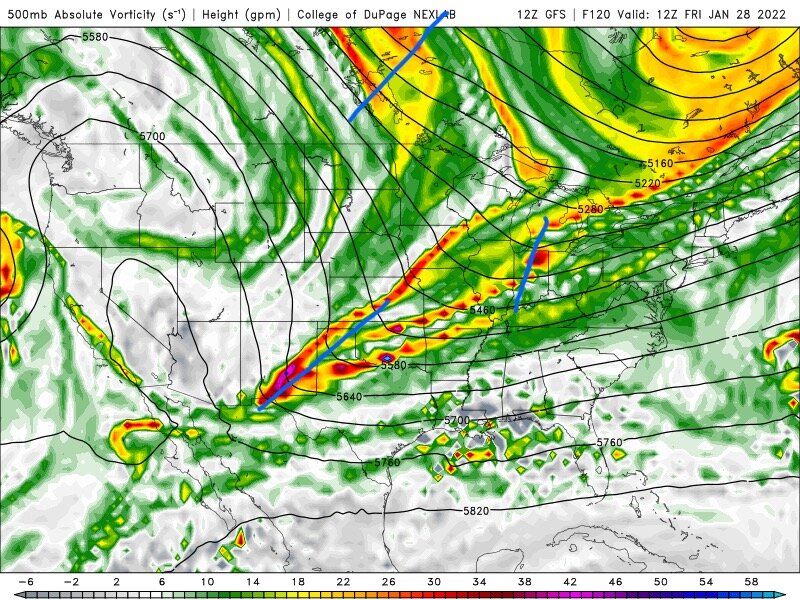
That trailing s/w coming out of Canada that phases in late to really nuke the system and tilt the trough negative is similarly timed though on both models. At 138h it’s over Lk Superior on both models. I feel like the GFS dragging that SW s/w out slower let’s that Canadian s/w phase in sooner westward whereas the wave spacing on the euro is larger and hence a later phase. The GGEM starts to really take on a different look after 102h. That western ridge really amplifies and the energy diving out of Canada comes in much steeper (N/S) and sooner and the whole system starts going bonkers early. so even though the southern s/w ejects out of the SW faster than the euro it’s getting the Canadian phasing sooner.
-
The initial s/w diving into the Plains kinda splits this run. There’s a piece to the north that runs out ahead of the stronger southern piece that really digs into and crawls through TX/NM. That northern piece that gets away seems to be flattening the heights ahead of the southern s/w and since it’s crawling to begin with there’s a major positive tilt to the trough. Eventually it starts to amplify and that northern piece dampens out. The s/w I mark in Canada eventually dives in to phase and clean everything out, but it’s just a little too late for us on this run. The models are still struggling with trying to find the little nuances in the flow which can make a big impact on the final outcome. As everyone else has said, the signal is there. Be happy with that and just keep an eye on it. It’s not worth getting emotionally invested into it right now.
-
Fizzling clipper tonight…that brought the light snow to Green Bay last night.
-
1.0° here. Couldn’t quite get below zero.


