

dendrite
-
Posts
75,088 -
Joined
Content Type
Profiles
Blogs
Forums
American Weather
Media Demo
Store
Gallery
Everything posted by dendrite
-

Blowvember - and not named for wind potential
dendrite replied to Go Kart Mozart's topic in New England
45/19 Lots to do this weekend. Was going well for an hour and then triggered bad back spasms so I'm out of commission. Anyway, ground is still moist here. The dry weather is great. -
Blowvember - and not named for wind potential
dendrite replied to Go Kart Mozart's topic in New England
CON gusted to 45mph in the past hour. It’s ripping out there. -
Blowvember - and not named for wind potential
dendrite replied to Go Kart Mozart's topic in New England
36° but it feels like below zero to me right now. -
Blowvember - and not named for wind potential
dendrite replied to Go Kart Mozart's topic in New England

-
14th Lawn and Garden Thread P Allen Smith 2024
dendrite replied to Damage In Tolland's topic in New England
Ha Gene. Looks like May there before leafout. -
Blowvember - and not named for wind potential
dendrite replied to Go Kart Mozart's topic in New England
Had a couple of showers…I swear one started with pingers. 46° now. -
Blowvember - and not named for wind potential
dendrite replied to Go Kart Mozart's topic in New England
31.1° with some frost -
Blowvember - and not named for wind potential
dendrite replied to Go Kart Mozart's topic in New England
BDL is official since the airport took over. The threaded historical obs include the old siting. That’s why all of the official climo stations have “area” since there are slight changes to the siting. BDL isn’t much different from HFD minus a little latitude. -
At least it’s still May
-
Blowvember - and not named for wind potential
dendrite replied to Go Kart Mozart's topic in New England
80s with dews CON-south today with a Groundhog Day sun angle. Surreal. -
Blowvember - and not named for wind potential
dendrite replied to Go Kart Mozart's topic in New England
This is the 3rd time BDL has hit 84° since Halloween. Previous latest 84° was last year on 10/28. Previous before that was 85° on 10/23/1947. -
Blowvember - and not named for wind potential
dendrite replied to Go Kart Mozart's topic in New England
BDL hit 84° lolol -
Blowvember - and not named for wind potential
dendrite replied to Go Kart Mozart's topic in New England
The 80° at CON is a record for the warmest for so late in the season. Previous record was 78° in 2022. lol -
Blowvember - and not named for wind potential
dendrite replied to Go Kart Mozart's topic in New England
lol holy hell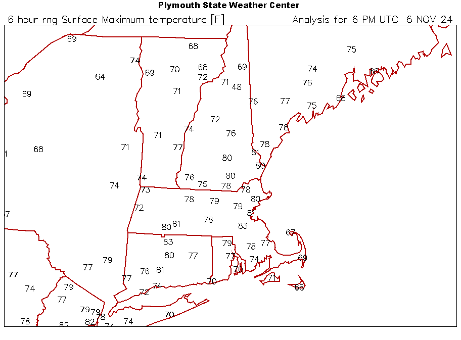
-
Blowvember - and not named for wind potential
dendrite replied to Go Kart Mozart's topic in New England
Wow. Got down to 51.5° here. Up to 64°. -
Blowvember - and not named for wind potential
dendrite replied to Go Kart Mozart's topic in New England
Legit felt like early June this morning. Unreal. -
Maybe your peppers will make it to next spring.
-
Still crickets in the yard.
-
Blowvember - and not named for wind potential
dendrite replied to Go Kart Mozart's topic in New England
MAV has 80° at BDL now tomorrow. That would be the latest 80° on record. LFG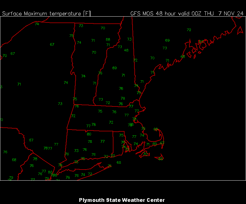
-
Blowvember - and not named for wind potential
dendrite replied to Go Kart Mozart's topic in New England
It’s the max temp for the day ending at that time. -
Blowvember - and not named for wind potential
dendrite replied to Go Kart Mozart's topic in New England
Only 60s and low 70s tomorrow. Chilly.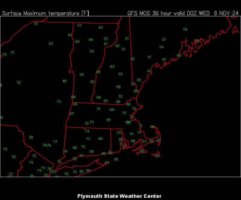
-
Blowvember - and not named for wind potential
dendrite replied to Go Kart Mozart's topic in New England
MOSGW
-
Blowvember - and not named for wind potential
dendrite replied to Go Kart Mozart's topic in New England
Honestly no thoughts. I have looked at nothing. It’s always a wild card here anyway with the amount of ways it can snow and retain pack. I don’t like looking out beyond 2-3 weeks anyway…not my thang. -
Blowvember - and not named for wind potential
dendrite replied to Go Kart Mozart's topic in New England
In a couple months the seed starting gear will be out in the box stores. -
Blowvember - and not named for wind potential
dendrite replied to Go Kart Mozart's topic in New England
Cold fail up here. Got down to 25.9°, but 29° now with some clouds. CON did sneak in a 22° though. It’s all up from here this week.


