

dendrite
-
Posts
75,073 -
Joined
Content Type
Profiles
Blogs
Forums
American Weather
Media Demo
Store
Gallery
Everything posted by dendrite
-

December 2024 - Best look to an early December pattern in many a year!
dendrite replied to FXWX's topic in New England
Looks like the warminista alter ego of Mark Moregarbage -
December 2024 - Best look to an early December pattern in many a year!
dendrite replied to FXWX's topic in New England
Sunsets start getting later after today. -
December 2024 - Best look to an early December pattern in many a year!
dendrite replied to FXWX's topic in New England
Reggie is a torch -
December 2024 - Best look to an early December pattern in many a year!
dendrite replied to FXWX's topic in New England
70-80kt at 925 inland with dews pushing 60°. -
December 2024 - Best look to an early December pattern in many a year!
dendrite replied to FXWX's topic in New England
Word of yore. It usually referred to river flooding involving heavy rain and snow melt. -
December 2024 - Best look to an early December pattern in many a year!
dendrite replied to FXWX's topic in New England
Probably not much on the main roads. We’ll likely warm up here behind the cold front with mixing. Westerly upslope spots will obviously have more efficient cooling with the onset of the CAA. -
December 2024 - Best look to an early December pattern in many a year!
dendrite replied to FXWX's topic in New England
GFS bringing the freshet to NNE -
December 2024 - Best look to an early December pattern in many a year!
dendrite replied to FXWX's topic in New England
Where have you been the last decade? -
December 2024 - Best look to an early December pattern in many a year!
dendrite replied to FXWX's topic in New England
2.1” Up to 11.4” on the season -
December 2024 - Best look to an early December pattern in many a year!
dendrite replied to FXWX's topic in New England
27.5° -SN -
December 2024 - Best look to an early December pattern in many a year!
dendrite replied to FXWX's topic in New England
The primary goes through Montreal. 925 shoots up over 12C into the interior. -
New England Winter 2024-25 Bantering, Whining, and Sobbing Thread
dendrite replied to klw's topic in New England
Tires of yore -
December 2024 - Best look to an early December pattern in many a year!
dendrite replied to FXWX's topic in New England
Looks like everyone in town felt it based on FB. Maybe a frostquake? -
December 2024 - Best look to an early December pattern in many a year!
dendrite replied to FXWX's topic in New England
Holy crap house just violently shook -
December 2024 - Best look to an early December pattern in many a year!
dendrite replied to FXWX's topic in New England
Almost the same here. 24° -SG dusting 7” depth -
December 2024 - Best look to an early December pattern in many a year!
dendrite replied to FXWX's topic in New England
Getting some snizzle right now. 18.8° -SG -
December 2024 - Best look to an early December pattern in many a year!
dendrite replied to FXWX's topic in New England
Mins were pretty early. LCI was before 6z. -
December 2024 - Best look to an early December pattern in many a year!
dendrite replied to FXWX's topic in New England
Tenths? -
December 2024 - Best look to an early December pattern in many a year!
dendrite replied to FXWX's topic in New England
Min 12.1° First single digits at a lot of sites up here. LCI 9° and maybe CON (10° so far). -
December 2024 - Best look to an early December pattern in many a year!
dendrite replied to FXWX's topic in New England
Scooter McGavin
-
New England Winter 2024-25 Bantering, Whining, and Sobbing Thread
dendrite replied to klw's topic in New England
Never used them…just all season tires. -
December 2024 - Best look to an early December pattern in many a year!
dendrite replied to FXWX's topic in New England
GFS already has me wedged by the time the cold fropa arrives. I probably won’t be feeling those sweet dews.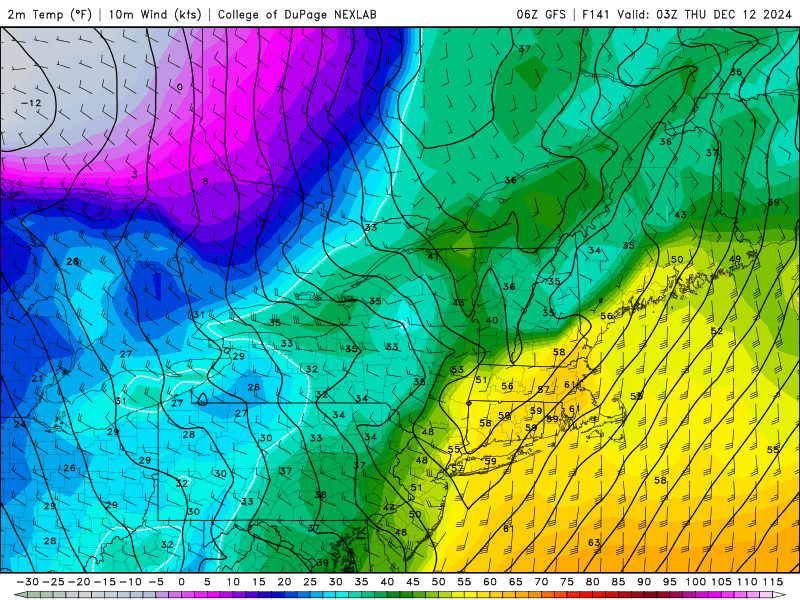
-
December 2024 - Best look to an early December pattern in many a year!
dendrite replied to FXWX's topic in New England
-
December 2024 - Best look to an early December pattern in many a year!
dendrite replied to FXWX's topic in New England
-
December 2024 - Best look to an early December pattern in many a year!
dendrite replied to FXWX's topic in New England
Were your previous ones not legit?


