dendrite
-
Posts
68,627 -
Joined
Content Type
Profiles
Blogs
Forums
American Weather
Media Demo
Store
Gallery
Everything posted by dendrite
-

July 2025 Obs/Disco ... possible historic month for heat
dendrite replied to Typhoon Tip's topic in New England
And they did. -
July 2025 Obs/Disco ... possible historic month for heat
dendrite replied to Typhoon Tip's topic in New England
It blows my mind that CON had 15 July mins in the 40s in 1965. Then they finished August that year with a 29°. We have trouble even getting 1 morning in the 40s now. Looks like if you add all of the July 40s going back from present to 2011 you get 15. Greta bringin the dews now. Guess we’ll see in a min if CON snuck in a 49°. -
July 2025 Obs/Disco ... possible historic month for heat
dendrite replied to Typhoon Tip's topic in New England
Min 51.0° -
July 2025 Obs/Disco ... possible historic month for heat
dendrite replied to Typhoon Tip's topic in New England
Cats and chickens And I don’t want the debris in my yard -
July 2025 Obs/Disco ... possible historic month for heat
dendrite replied to Typhoon Tip's topic in New England
58 and dz with low ceilings would be better. F up these firework displays. -
July 2025 Obs/Disco ... possible historic month for heat
dendrite replied to Typhoon Tip's topic in New England
102/70 is a nice comfy 36% RH too. -
Here come the redneck fireworks. So annoying.
-
July 2025 Obs/Disco ... possible historic month for heat
dendrite replied to Typhoon Tip's topic in New England
2009 rainy and raw 2007 chilly start 2001 chilly 7/4/92 nastiest 4th ever -
July 2025 Obs/Disco ... possible historic month for heat
dendrite replied to Typhoon Tip's topic in New England
67.9/52 SCT A nice change of pace, COC day. -
July 2025 Obs/Disco ... possible historic month for heat
dendrite replied to Typhoon Tip's topic in New England
The biggest anomalies in the extended could still be over SNE. Sites are already +5 to +7 coming in to today with big + anomalies Sun and Mon. BDL will probably be safe because the sensor is finally fixed but top 5 is still in play in most places. It only takes a few cool days to ruin it though. -
July 2025 Obs/Disco ... possible historic month for heat
dendrite replied to Typhoon Tip's topic in New England
Huh? Over the top can be big heat. -
July 2025 Obs/Disco ... possible historic month for heat
dendrite replied to Typhoon Tip's topic in New England
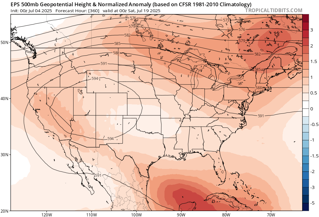
588 at d15 is torch heights. Even today will be near normal at many sites despite the COC. I just wouldn’t be slam dunking either way at this point. We’re going to come out of the first week with some relatively big + anomalies for July. -
July 2025 Obs/Disco ... possible historic month for heat
dendrite replied to Typhoon Tip's topic in New England
588dm mean over SNE d15. Is that supposed to be cold?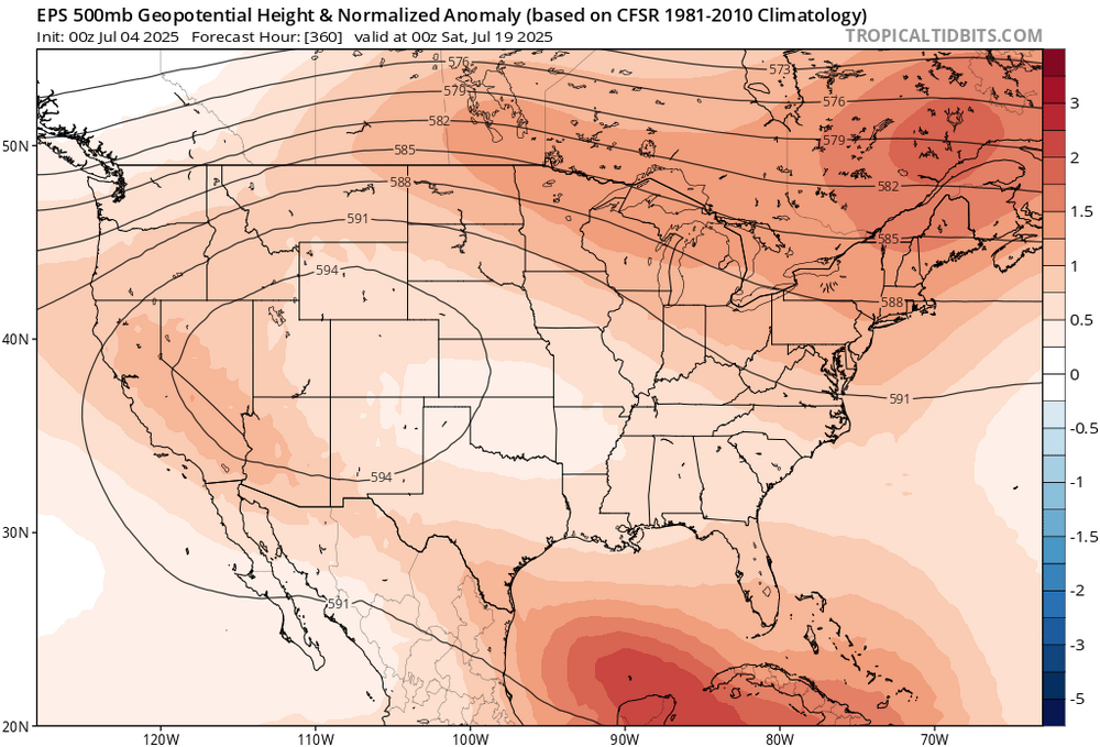
-
July 2025 Obs/Disco ... possible historic month for heat
dendrite replied to Typhoon Tip's topic in New England
I wouldn’t rule out top 5 yet. -
July 2025 Obs/Disco ... possible historic month for heat
dendrite replied to Typhoon Tip's topic in New England
114 years ago today One of the hottest New England days on record…especially north of Pike All time records for VT and NH (ME was 6 days later) BOS 104 PWM 103 CON 102 ORH 102 (old site but only 100+ on record) -
July 2025 Obs/Disco ... possible historic month for heat
dendrite replied to Typhoon Tip's topic in New England
Extended looks warm -
July 2025 Obs/Disco ... possible historic month for heat
dendrite replied to Typhoon Tip's topic in New England
Horrible. Save that shit for Christmas. -
July 2025 Obs/Disco ... possible historic month for heat
dendrite replied to Typhoon Tip's topic in New England
Hopefully better than he handles a daddy longleg. -
July 2025 Obs/Disco ... possible historic month for heat
dendrite replied to Typhoon Tip's topic in New England
63.6° -RA -
July 2025 Obs/Disco ... possible historic month for heat
dendrite replied to Typhoon Tip's topic in New England
Afternoon before the 4th…was probably at a standstill anyway. -
July 2025 Obs/Disco ... possible historic month for heat
dendrite replied to Typhoon Tip's topic in New England
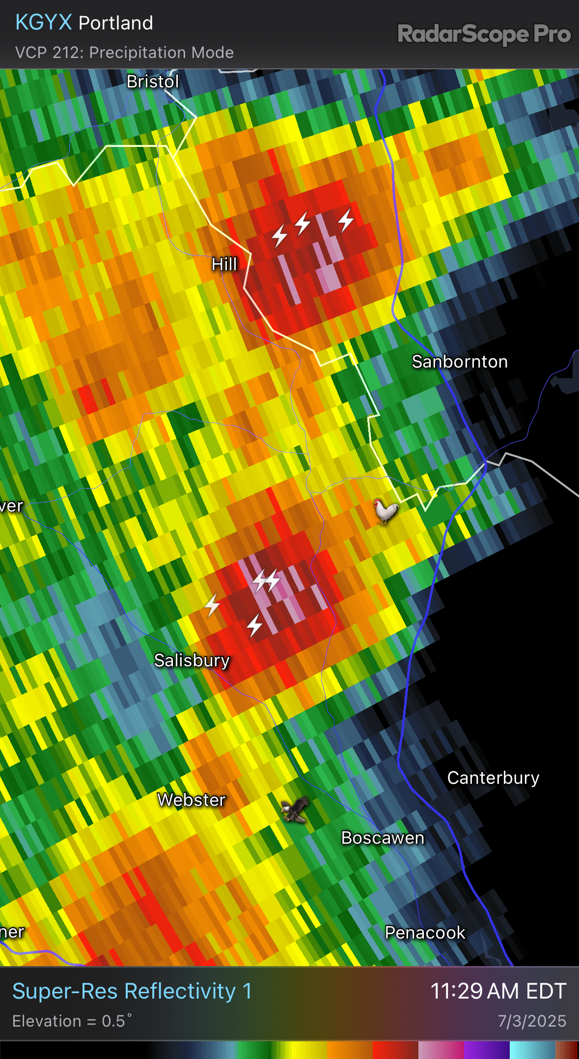
Contoocook reporting 1/2” hail again -
July 2025 Obs/Disco ... possible historic month for heat
dendrite replied to Typhoon Tip's topic in New England
Shit I don’t need hail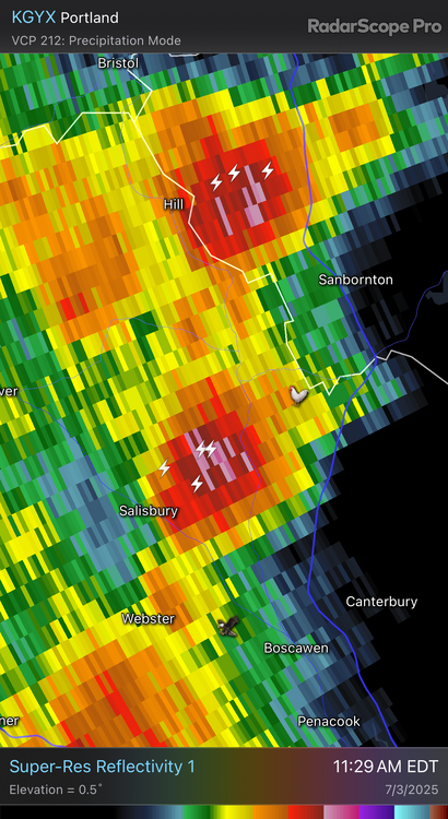
-
July 2025 Obs/Disco ... possible historic month for heat
dendrite replied to Typhoon Tip's topic in New England
Almost 80dBZ up in the county must’ve been fun -
July 2025 Obs/Disco ... possible historic month for heat
dendrite replied to Typhoon Tip's topic in New England
Let’s wash out Center Harbor and the Weirs again
-
July 2025 Obs/Disco ... possible historic month for heat
dendrite replied to Typhoon Tip's topic in New England
My trees need it. Sorry about rain on the ski bob.