dendrite
-
Posts
75,076 -
Joined
Content Type
Profiles
Blogs
Forums
American Weather
Media Demo
Store
Gallery
Everything posted by dendrite
-

-
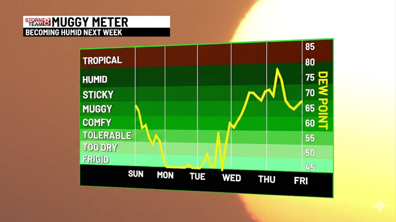
What in the sam hell am I trying to interpret here
-
Wish we could get one of the universities to run it...at least the 3k. But it would be a bad look for NCEP if everyone started flocking to Ewall or SUNY to see every NAM run while Rufus has more tumbleweeds than views. I think they've made their bed and they'll have to lie in it either way. At least they were smart enough to wait until the end of met summer/severe wx season before ending it. I wish more free models sites had the RRFS data. I like COD and Tidbits for quick and easy viewing. I get a little lost on what I'm clicking at Pivotal sometimes.
-
Min 48.8°…sucks but it’s still early June. Still looks cooler next week…maybe more like mild downs in SNE. EC tries to sneak a low under NNE which would make for a mank day. Keep the mean trough in the midwest and we’ll be okay most days.
-
-
Def cooler next week.
-
33° at Estcourt Station. Some mid 30s in N NH and W ME too.
-
Min 47.7° Hopefully some rain midweek
-
People scalp their lawns to 1” high weekly, pile on weed killer, and wonder why cold season grasses struggle after 5 days without significant rain.
-
We’re only a week in. I ended May with the 2”+ event so we’re good for now. But yeah, dry 80s for a week will have his webbed hands around my throat.
-
-
0.01” or 0.02”?
-
64/59 Breezy and a little chilly. Hoodie evening.
-
How's the fert?
-
We do 70+ dews a lot more than we used to. We deserve a 75+ category now. Gotta change with the times.
-
Clouds really fired up ahead of the boundary in S NH. Down to 69/60 here. Maybe we pop some cells if we clear out behind this line of SHRA.
-
The showers dropping in from the north look like weak sauce. 3k tries to fire some isolated convection along the boundary later…we shall see. Setting in by mid June…just like clockwork.
-
Looks good but had to edit it a bit.

-
Yeah the wind really picked up in the last half hour. 69/60 Feels chilly!
-
0.02” yesterday separated between two 0.01” showers.
-
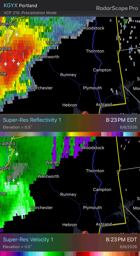
Preliminary Local Storm Report National Weather Service Gray ME 950 PM EDT Sat Jun 6 2026 ..TIME... ...EVENT... ...CITY LOCATION... ...LAT.LON... ..DATE... ....MAG.... ..COUNTY LOCATION..ST.. ...SOURCE.... ..REMARKS.. 0857 PM Tstm Wnd Dmg 1 NNE Plymouth 43.77N 71.68W 06/06/2026 Grafton NH Public Two trees down on Interstate 93 north, blocking several lanes.
-

-
It’s yellow boxed
-
Nice meso with that. In the cityyyy…city of Campton

-
Nice bow ripping through Rumney/Campton