dendrite
-
Posts
67,071 -
Joined
Content Type
Profiles
Blogs
Forums
American Weather
Media Demo
Store
Gallery
Everything posted by dendrite
-

May obs/discussion thread - Welcome to Severe Season!!
dendrite replied to weatherwiz's topic in New England
CON 25° Looks like 28.3° will do it here. I’ll probably lose a few apple blossoms, bit nothing too bad…not sure how the emerging pawpaw foliage will react. -
May obs/discussion thread - Welcome to Severe Season!!
dendrite replied to weatherwiz's topic in New England
29.3° so far. CON 26° and HIE 19° Still a couple of hours to go unfortunately -
May obs/discussion thread - Welcome to Severe Season!!
dendrite replied to weatherwiz's topic in New England
35° -
May obs/discussion thread - Welcome to Severe Season!!
dendrite replied to weatherwiz's topic in New England
39.4° -
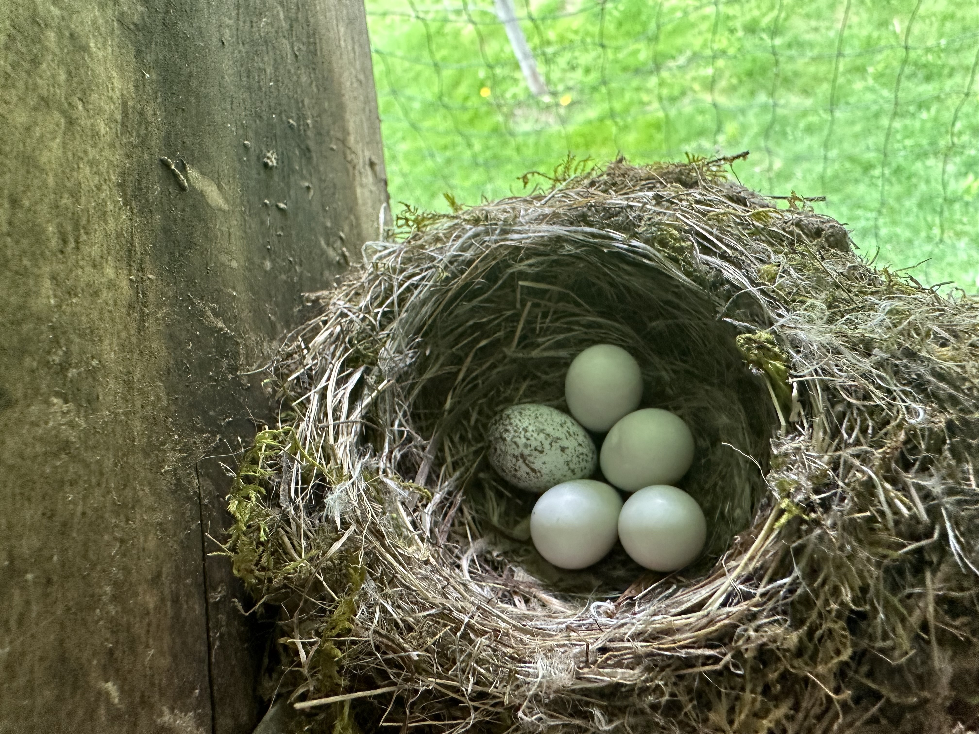
Well the cowbirds are a “parasitic” bird. The mother lays eggs in the nests of other birds and doesn’t raise them on her own until they leave the nest. The cowbird eggs tend to hatch first and grow larger more rapidly and the babies can actually toss the youngins from the other bird out of the nest. So the cowbird has a distinct advantage over the other phoebes. The cowbirds are native so this is a natural thing that has been happening for some time. But I’d rather lose 1 cowbird than risk losing 4 phoebes.
-
May obs/discussion thread - Welcome to Severe Season!!
dendrite replied to weatherwiz's topic in New England
12z MAV with a 12° for BML. lol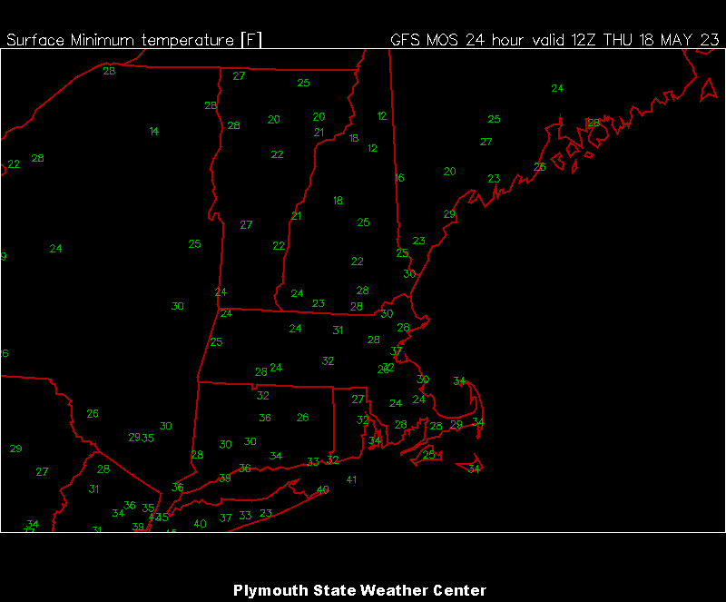
-
May obs/discussion thread - Welcome to Severe Season!!
dendrite replied to weatherwiz's topic in New England
nah they like the cooler temps. They would install in April like you if they could. -
May obs/discussion thread - Welcome to Severe Season!!
dendrite replied to weatherwiz's topic in New England
Reverse the AC and blow the hot air in? -
The 2023 Lawn, Garden, Landscape Party Discussion
dendrite replied to Damage In Tolland's topic in New England
Hoping for 30+ here and only a couple hours of it. Better yet, keep the wind up and stay above freezing. The apples and pears are pretty tough so I'm not too worried about them unless we start getting into the 20s. The orchards in the MRV may be a different story...especially CON/Loudon. I'm worried there will be no PYO peaches at Carter Hill Orchard this year. I haven't had a lot of experience with this much cold this late with my pawpaw trees, but I think they'll be fine too. It is what it is. Most of the potted plants will be coming in...even the figs and avocados. I did have the avos outside for that May 2020 snow/cold event and they survived despite a little leaf burning. -
May obs/discussion thread - Welcome to Severe Season!!
dendrite replied to weatherwiz's topic in New England
Pretty cold airmass for the 2nd half of May. Sometimes we can go a week in January higher than this.
-
May obs/discussion thread - Welcome to Severe Season!!
dendrite replied to weatherwiz's topic in New England
He'll run with his bush league high of 63F at 1am. -
May obs/discussion thread - Welcome to Severe Season!!
dendrite replied to weatherwiz's topic in New England
Sorry...the 50/21 was CON, not here. I'm only 46.8F right now at 1pm. -
May obs/discussion thread - Welcome to Severe Season!!
dendrite replied to weatherwiz's topic in New England
You’ll be ok on the hill I think if the CON min is 27°+. I’ll be borderline here. I’m leaning something like 32-34° there, 30-32° here, and 27-29° at CON. -
May obs/discussion thread - Welcome to Severe Season!!
dendrite replied to weatherwiz's topic in New England
Not a fan of seeing 50/21 right now though. -
May obs/discussion thread - Welcome to Severe Season!!
dendrite replied to weatherwiz's topic in New England
I’ll take the over on that 22° for CON. The 5/18 record is 25°, the latest 22° is 5/11/1900, and it has also never been colder than 24° past that 5/11 date. -
May obs/discussion thread - Welcome to Severe Season!!
dendrite replied to weatherwiz's topic in New England
Yikes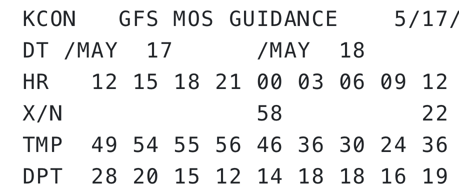
-
May obs/discussion thread - Welcome to Severe Season!!
dendrite replied to weatherwiz's topic in New England
I wish. That would at least smell like Subway. -
May obs/discussion thread - Welcome to Severe Season!!
dendrite replied to weatherwiz's topic in New England
Smells like an ash tray out here this evening. The sun has been orange-red for hours -
May obs/discussion thread - Welcome to Severe Season!!
dendrite replied to weatherwiz's topic in New England
Undulatus asperatus -
So I have an eastern phoebe brooding under the roof of my chicken run. I went up to check the eggs a bit ago and noticed a speckled egg mixed in that belongs to a brown headed cowbird. What’s the protocol on that? Should I remove the egg so that the phoebes have a better chance at survival or let nature be?

-
May obs/discussion thread - Welcome to Severe Season!!
dendrite replied to weatherwiz's topic in New England
12z MAV for Thu morning. Not a fan.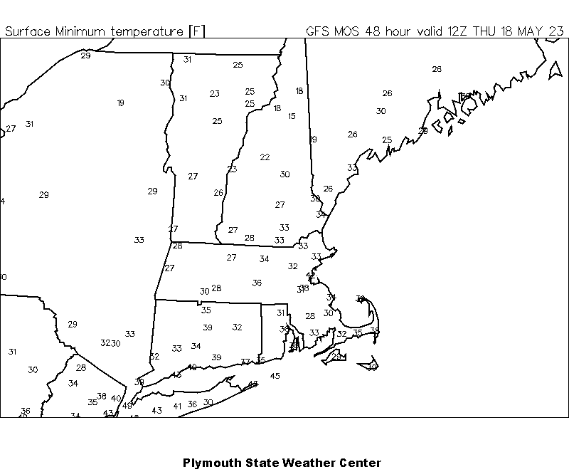
-
May obs/discussion thread - Welcome to Severe Season!!
dendrite replied to weatherwiz's topic in New England
Up to 69F It'd be nice to see the sun today. -
May obs/discussion thread - Welcome to Severe Season!!
dendrite replied to weatherwiz's topic in New England
Definitely a golden glow out there today. -
May obs/discussion thread - Welcome to Severe Season!!
dendrite replied to weatherwiz's topic in New England
Oh that was my point. Less shortwave heating during the day, but not much longwave effect at night. -
May obs/discussion thread - Welcome to Severe Season!!
dendrite replied to weatherwiz's topic in New England
In cases where it’s thinner…doesn’t it affect shortwave rad more than longwave?