dendrite
-
Posts
66,943 -
Joined
Content Type
Profiles
Blogs
Forums
American Weather
Media Demo
Store
Gallery
Everything posted by dendrite
-
Answered my own Q...looks sus DFW,1958-08-21 07:00,KDFW 210700Z AUTO 22508KT 10SM CLR CLR CLR 24/23 RMK SLP115 T02390228 IEM_DS3505 DFW,1958-08-21 08:00,KDFW 210800Z AUTO 22507KT 10SM CLR CLR CLR 23/22 RMK SLP109 T02330222 IEM_DS3505 DFW,1958-08-21 09:00,KDFW 210900Z AUTO 15807KT 10SM CLR CLR CLR 24/22 RMK SLP113 T02390217 IEM_DS3505 DFW,1958-08-21 10:00,KDFW 211000Z AUTO 31509KT 10SM CLR CLR CLR 24/22 RMK SLP126 T02390217 IEM_DS3505 DFW,1958-08-21 11:00,KDFW 211100Z AUTO 04503KT 10SM CLR CLR CLR 24/23 RMK SLP130 T02390228 IEM_DS3505 DFW,1958-08-21 12:00,KDFW 211200Z AUTO 29310KT 15SM CLR CLR CLR 24/23 RMK SLP140 T02390228 IEM_DS3505 DFW,1958-08-21 13:00,KDFW 211300Z AUTO 24806KT 10SM CLR CLR CLR 24/23 RMK SLP143 T02390228 IEM_DS3505 DFW,1958-08-21 14:00,KDFW 211400Z AUTO 20307KT 12SM CLR CLR 24/23 RMK SLP138 T02390233 IEM_DS3505 DFW,1958-08-21 15:00,KDFW 211500Z AUTO 20311KT 15SM CLR CLR CLR 26/24 RMK SLP137 T02560239 IEM_DS3505 DFW,1958-08-21 16:00,KDFW 211600Z AUTO 24809KT 6SM CLR CLR CLR 26/24 RMK SLP141 T02560239 IEM_DS3505 DFW,1958-08-21 17:00,KDFW 211700Z AUTO 24807KT 15SM CLR CLR 26/26 RMK SLP137 T02610256 IEM_DS3505 DFW,1958-08-21 18:00,KDFW 211800Z AUTO 31508KT 15SM CLR 27/27 RMK SLP137 T02720267 IEM_DS3505 DFW,1958-08-21 19:00,KDFW 211900Z AUTO 29312KT 15SM CLR 28/27 RMK SLP134 T02780272 IEM_DS3505 DFW,1958-08-21 20:00,KDFW 212000Z AUTO 33812KT 15SM CLR CLR 28/28 RMK SLP130 T02830283 IEM_DS3505 DFW,1958-08-21 21:00,KDFW 212100Z AUTO 33810KT 15SM CLR CLR 28/22 RMK SLP127 T02780222 IEM_DS3505 DFW,1958-08-21 22:00,KDFW 212200Z AUTO 33809KT 15SM CLR CLR 28/22 RMK SLP127 T02780222 IEM_DS3505 DFW,1958-08-21 23:00,KDFW 212300Z AUTO 33811KT 15SM CLR CLR 28/23 RMK SLP130 T02780228 IEM_DS3505 DFW,1958-08-22 00:00,KDFW 220000Z AUTO 31509KT 15SM CLR CLR 26/23 RMK SLP128 T02560233 IEM_DS3505
-
Is this 1958 day from a toss-worthy psychrometer?
-
I've been seeing more and more of those asian tiger mosquitos up here. I swear 90% of the ones I kill are those.
-
-
The black flies were probably the worst I've ever seen them up here back in May. They're still hanging around...just not as bad. The mosquitos were really bad a couple of weeks ago, but they've tapered off too. Now we have some noseeums creeping in. The ticks have been off the charts. I've seen over 2 dozen of them so far...pulled 3 off my leg in the past week.
-
I like how we have no problem pulling 50s in june and january now.
-
Hope so...this last period was a fail locally.
-
It won't be remembered
-
0.03” since 7am
-
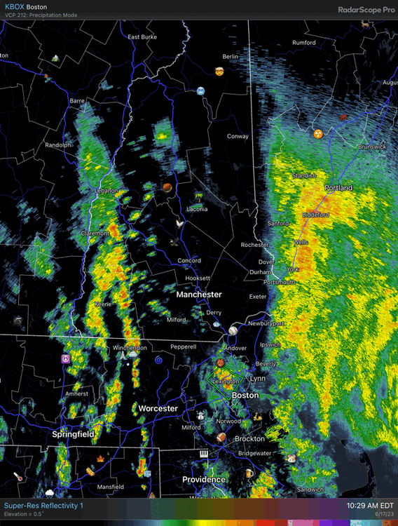
Cells to the left of me, soakers to the right Here I am stuck in the middle with
-
Missing everything again. jfc
-
0.05” of meh. We need a good soaker.
-
Getting pounded with Styx 8 tracks

-
There's still a large amount of ash here although there's spots around CON where they've been hit hard. I have seeds and seedlings popping up everywhere in the front yard including my mulched bed in the front where my large rhodies are. The Darling-58 chestnut should get federal approval this year and then we'll start seeing its availability increase over the next few years to the general public.
-
They were brought into E MA in the late 1890s and spread rapidly through the eastern half of New England over the next 20 years before rapidly receding due to multiple prevention measures. They had them knocked back to the Cape and the Casco Bay area in the 70s, but obviously they’re making another surge through Maine now.
-
It was ugly here too. https://www.wmur.com/article/apple-trees-frost-southern-new-hampshire-6223/44080251# https://www.wmur.com/article/labelle-winery-crop-damaged-frost-new-hampshire/43982251
-
Falling apart for you. I can’t wait for my 0.10” of moderate rain incoming.
-
Hopefully it doesn’t pour on the bikers.
-
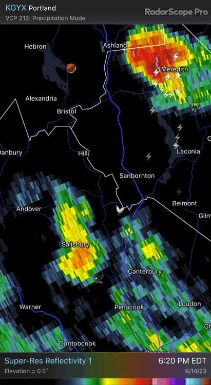
The wind raged here briefly on the outer edge
-
-
I’m reinstalling the pellet stove.
-
-

The 2023 Lawn, Garden, Landscape Party Discussion
dendrite replied to Damage In Tolland's topic in New England
They kept chewing off the tops of my seedling plants. I put water out for the robin nesting in my garage and the chippies are drinking out of it too...and surprisingly no more plants are getting destroyed. Maybe they just needed some form of hydration? lol -
The 2023 Lawn, Garden, Landscape Party Discussion
dendrite replied to Damage In Tolland's topic in New England
More just move in. You need an outdoor cat or more hawks. -
Rain with 60s dews. We take. 0.30” so far. The soil has been getting dry…pushing 50cb.