dendrite
-
Posts
75,078 -
Joined
Content Type
Profiles
Blogs
Forums
American Weather
Media Demo
Store
Gallery
Everything posted by dendrite
-

November 2025 general discussions and probable topic derailings ...
dendrite replied to Typhoon Tip's topic in New England
There’s multiple cold shots before Thanksgiving. But yeah…maybe warming up more near the 20th, but that’s 2 weeks away. -
November 2025 general discussions and probable topic derailings ...
dendrite replied to Typhoon Tip's topic in New England
Where are you getting your big warmup? Late month maybe. -
November 2025 general discussions and probable topic derailings ...
dendrite replied to Typhoon Tip's topic in New England
Yeah there’s some showers coming this way…interested to see if there’s any frozen mixed in. -
Overnight Wednesday, November 5, 2025 Wind Event
dendrite replied to weatherwiz's topic in New England
Not sure I really called anything. The only thing I didn’t like was that the peak of the wind was all overnight. We’ve had good wind at night before, but this was more of a quick in and out impulse. That and the models kept backing off on the 850/925 winds the past couple of days. It’s tough to mix down what isn’t there. -
All in fun. You have a pretty good track record for near range calls for up here.
-
Overnight Wednesday, November 5, 2025 Wind Event
dendrite replied to weatherwiz's topic in New England
Def a boundary near the NH border. The 33s up north are snow.
-
Overnight Wednesday, November 5, 2025 Wind Event
dendrite replied to weatherwiz's topic in New England
41.7° no wind We’re kinda wedged up here…may take awhile to mix down decent gusts. -
November 2025 general discussions and probable topic derailings ...
dendrite replied to Typhoon Tip's topic in New England
We take! -
November 2025 general discussions and probable topic derailings ...
dendrite replied to Typhoon Tip's topic in New England
Yeah looks like there could be some decent accums in the slightly higher terrain in Coos and adjacent ME tonight. -
Overnight Wednesday, November 5, 2025 Wind Event
dendrite replied to weatherwiz's topic in New England
The first one you mentioned was over 20 years ago. I think you kinda proved my point. I want to say there was a good one in early 06 too…Feb maybe? -
13 10 from ginxy Only 1 verifies
-
Overnight Wednesday, November 5, 2025 Wind Event
dendrite replied to weatherwiz's topic in New England
The W-NW CAA winds generally are. We can do 45-55mph no problem, but the >55kt stuff is rare. The westerly component doesn’t do as much tree damage either since the trees grow braced against that flow. Give me a mixed down raging easterly LLJ over something this. -
November 2025 general discussions and probable topic derailings ...
dendrite replied to Typhoon Tip's topic in New England
This is more riveting than dew tracking -
November 2025 general discussions and probable topic derailings ...
dendrite replied to Typhoon Tip's topic in New England
Might be toast this Fri AM. -
53/52
-
I will say 3 flood warnings and 1 6”+ rain event.
-
Overnight Wednesday, November 5, 2025 Wind Event
dendrite replied to weatherwiz's topic in New England
Looks more like a SNE deal, but it’s too bad it doesn’t go through midday vs overnight. -
2025 Lawns & Gardens Thread. Making Lawns Great Again
dendrite replied to Damage In Tolland's topic in New England
Other way around….they’re burying/planting them. -
November 2025 general discussions and probable topic derailings ...
dendrite replied to Typhoon Tip's topic in New England
Severe for little peas? -
November 2025 general discussions and probable topic derailings ...
dendrite replied to Typhoon Tip's topic in New England
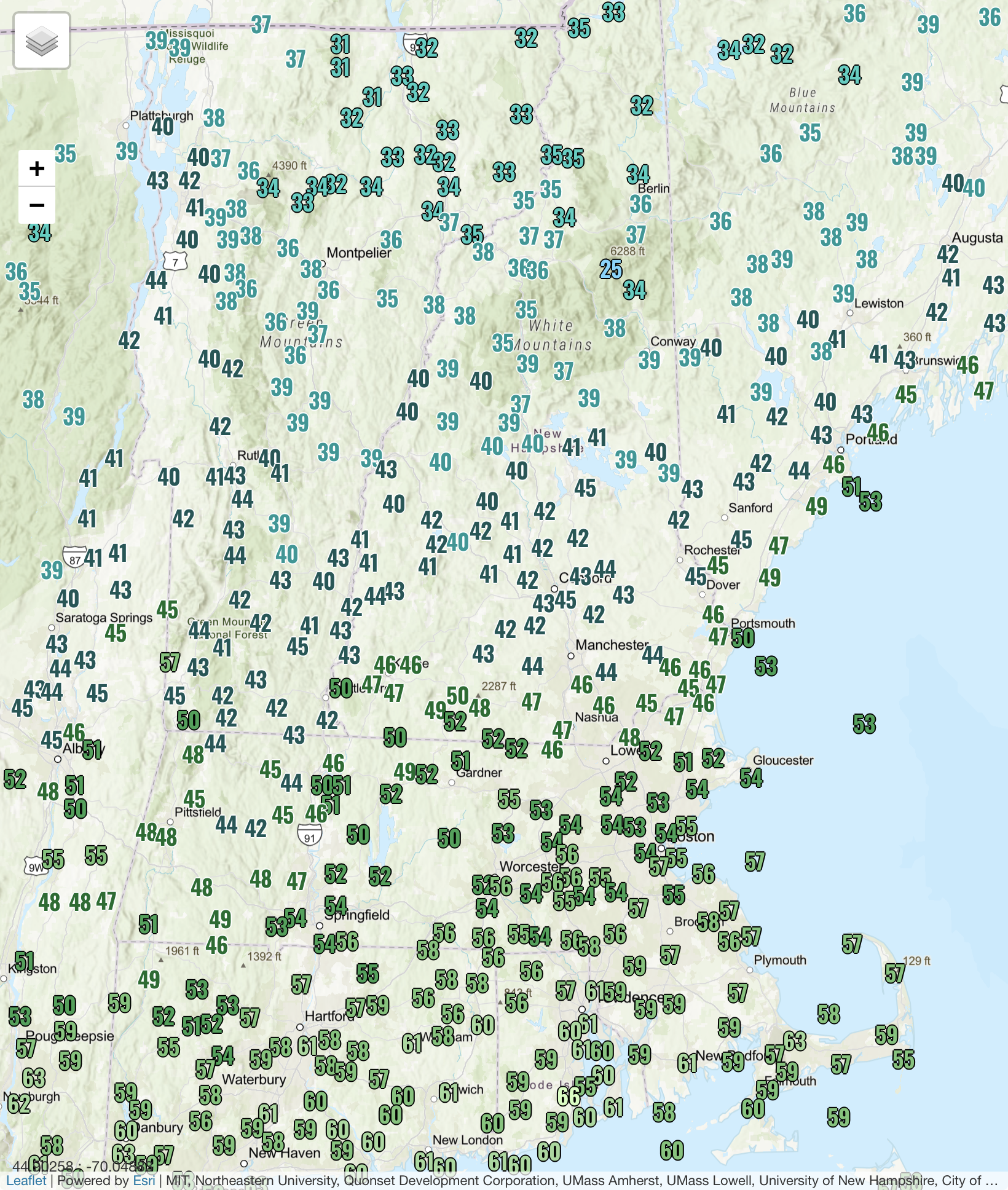
Snowing up at First Lake. 33F at the COOP. -
November 2025 general discussions and probable topic derailings ...
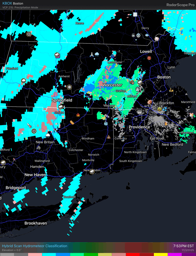
dendrite replied to Typhoon Tip's topic in New England
Yeah it’s just a color coded ptype algorithm. You can extrapolate from other dual pol products, but it’s easier for regular weenies to see. -
November 2025 general discussions and probable topic derailings ...
dendrite replied to Typhoon Tip's topic in New England
Low freezing levels and convection. Many are seeing some graupel make it to the sfc.
-
November 2025 general discussions and probable topic derailings ...
dendrite replied to Typhoon Tip's topic in New England
I’ll stop wishing when the well fully refills immediately after a load of laundry. -
November 2025 general discussions and probable topic derailings ...
dendrite replied to Typhoon Tip's topic in New England
Probably graupel/small hail? This is probably the heaviest burst of rain I had all warm season. -
November 2025 general discussions and probable topic derailings ...
dendrite replied to Typhoon Tip's topic in New England