dendrite
-
Posts
75,078 -
Joined
Content Type
Profiles
Blogs
Forums
American Weather
Media Demo
Store
Gallery
Everything posted by dendrite
-
You just love to see all of this
-
Deep, deep summer
-
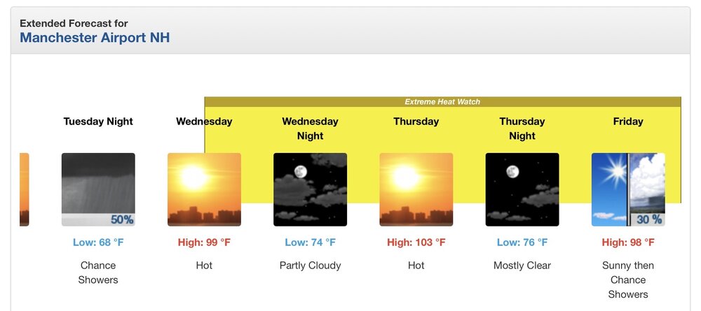
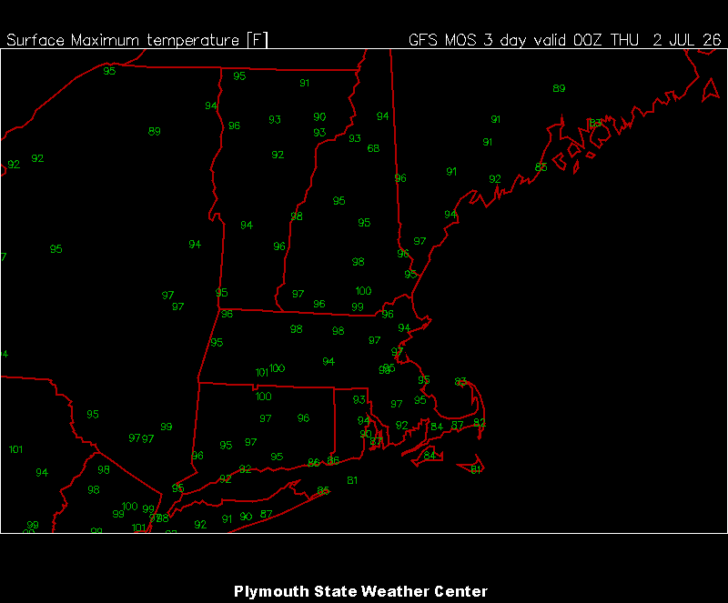
Beer? Wed is in the MOS plotting window on the Plymouth site now
-
Wow MEX has 3 straight days of 100° for BDL. B2B 100s for MHT 102° for CON, TAN, and BAF
-
He can still post. His and radarman’s temps will fit right in next winter.
-
Wow that’s quite the change. Good luck!
-
18z gfs brings the E taint late Fri into Saturday…especially eastern zones. Def gotta watch for that as the ridge relaxes just a bit and a weak s/w rounds it to our NE. Still a scorchah on Thu
-
I left guest viewing turned off, but I turned new registrations back on. Let me know if you experience slowdowns. I think it should be okay unless I get barraged with forum signups from overseas.
-

Intermittent (but frequent) Bad Gateway 502 Errors
dendrite replied to Kmlwx's topic in Forum Information & Help
I shut down guest viewing to block the 10k+ foreign IPs at once. The board instantly sped up after that. JohnWow will have to take a deeper look later. -
Can't browse while logged out
dendrite replied to JenkinsJinkies's topic in Forum Information & Help
Correct. we had over 10k "guests" from foreign IPs on the site at once and it was causing the slow forum issues. I had to shut the guest viewing down until John gets another look at it. -
I’ll stick with my upper 90s
-
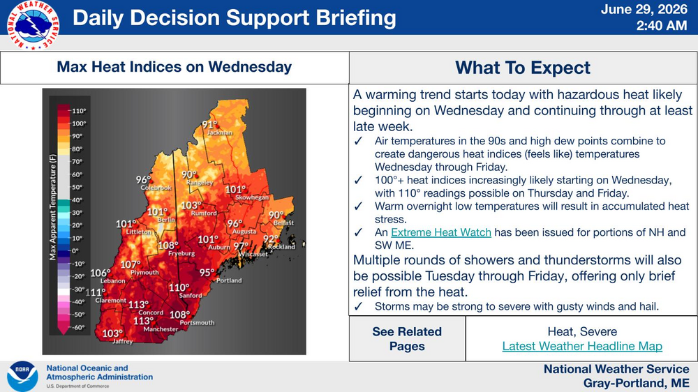
There’s really only a few days in the period of record (150+ years) where we’re pulling off widespread 102-104+ at the surface. I assume July 1911 everything went right for CNE to get all of those 102-106° readings. 850s must’ve been a solid 25-26C. With sun and no taint in the heart of warm season I just slap 15C onto the 850s this far out (for the valley hot spots) and adjust slightly upward or downward from there. I don’t see much reason to stray from upper 90s for the interior. Maybe an MCS or poorly timed cloud debris mucks it up, but not gonna overanalyze that in the mid range.
-
Sure. But it doesn’t take much sun near peak heating this time of year to tag +15C on top of those 850s at the sfc…especially away from the coast. I’d be shocked if BOS/PWM end up that cool throughout given the midlevel temps. It’s July…not May.
-
Ha…I was gonna say. You know where to find every model.
-
https://beta.pivotalweather.com/models/ecmwf_aifs/850th/us_ne?run=2026062800&forecastHour=6

-
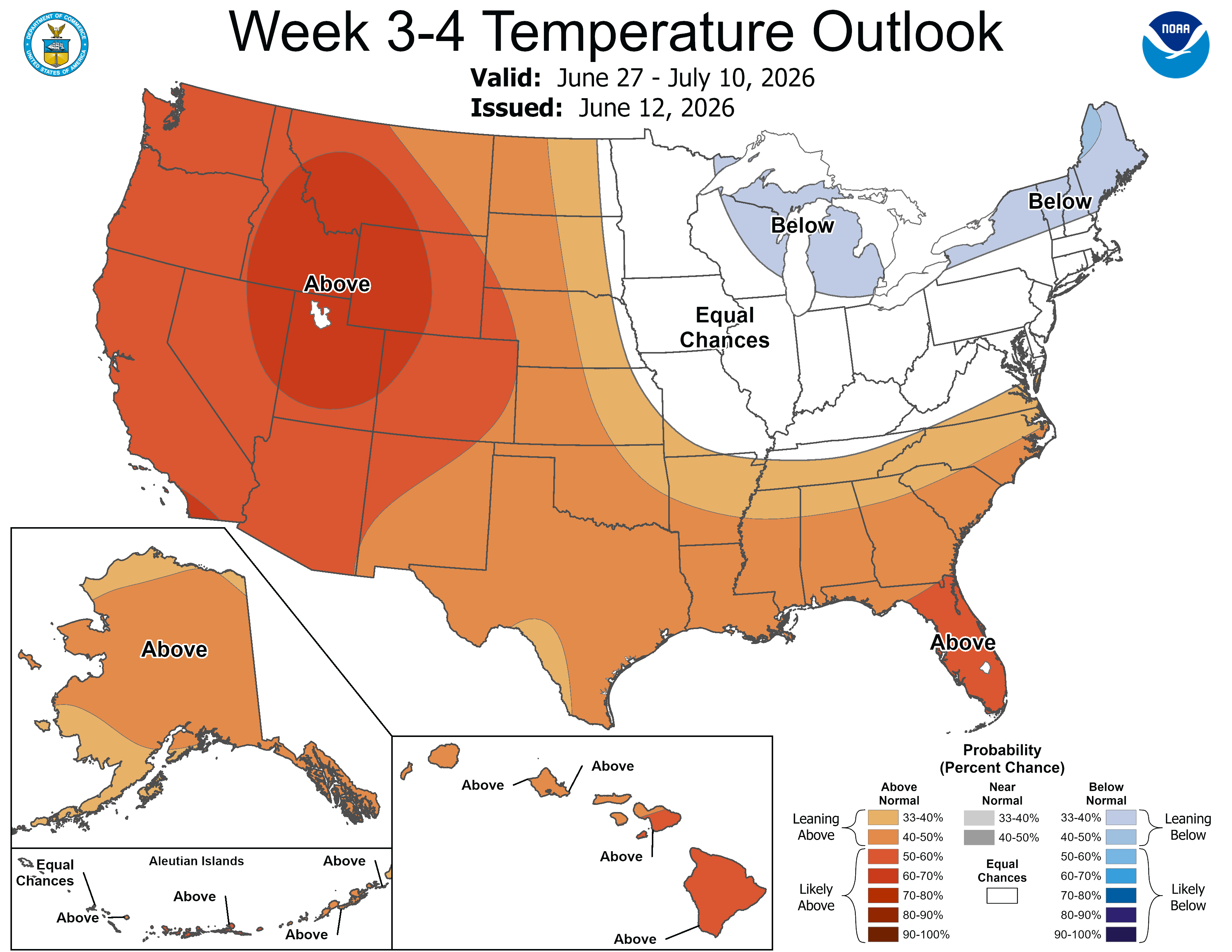
I preach that all of the time here. But you and I know what they mean by the maps. Their probabilities tend to correlate with anomalies. It takes a lot for them to paint any shade of blue on there in the 3-4 week window.
-
Inferno through Monday. What a holiday weekend. Wow.
-
I’m still feeling mostly 98-100 in the hot spots right now…not buying the 2m 103-105 stuff with 850s of only 22-23C. I’m sure EWR will drop a 104° one day over the tarmac though. Just imagine all of those sweathogs in DC later next week for the 250th. No thanks.
-
Yeah euro op is still pretty warm. Lots of 15-20C in the extended. ACATT squealing for help.
-
Hard L

-
BOX has 104° in the point click for downtown Boston. lol
-
Are you petrified?
-

-
MAAA Made AmericanWx American Again
-
The Legacy site has been slow loading images. The new one is fine.