dendrite
-
Posts
75,066 -
Joined
Content Type
Profiles
Blogs
Forums
American Weather
Media Demo
Store
Gallery
Everything posted by dendrite
-

November 2025 general discussions and probable topic derailings ...
dendrite replied to Typhoon Tip's topic in New England
18z gfs would push the 62° on Thanksgiving too if they could pop some sun in that warm sector. -
November 2025 general discussions and probable topic derailings ...
dendrite replied to Typhoon Tip's topic in New England
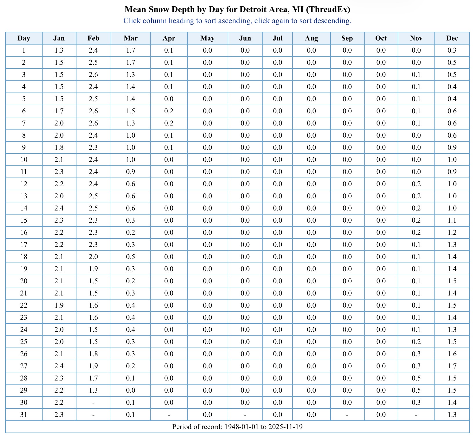
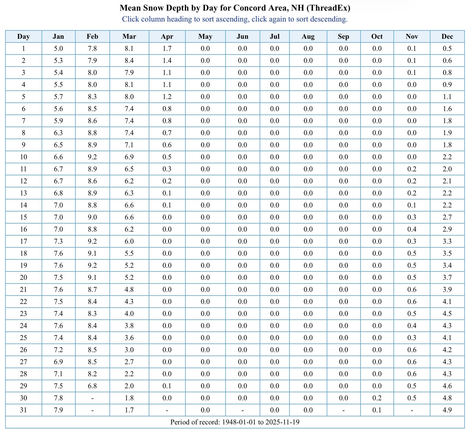
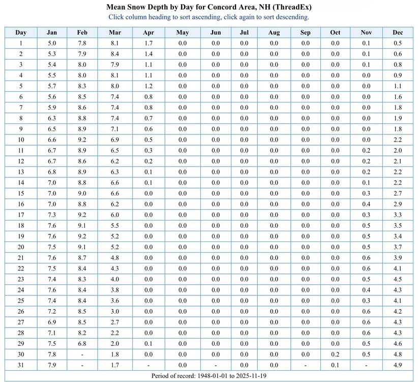
CON has historically been a hole, but they trounce DTW in avg depth.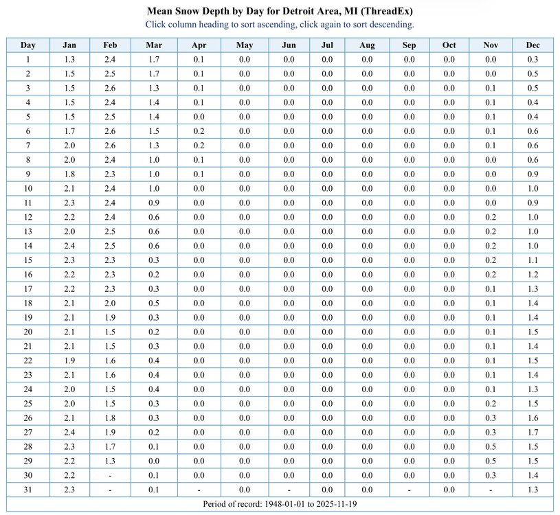
-
November 2025 general discussions and probable topic derailings ...
dendrite replied to Typhoon Tip's topic in New England
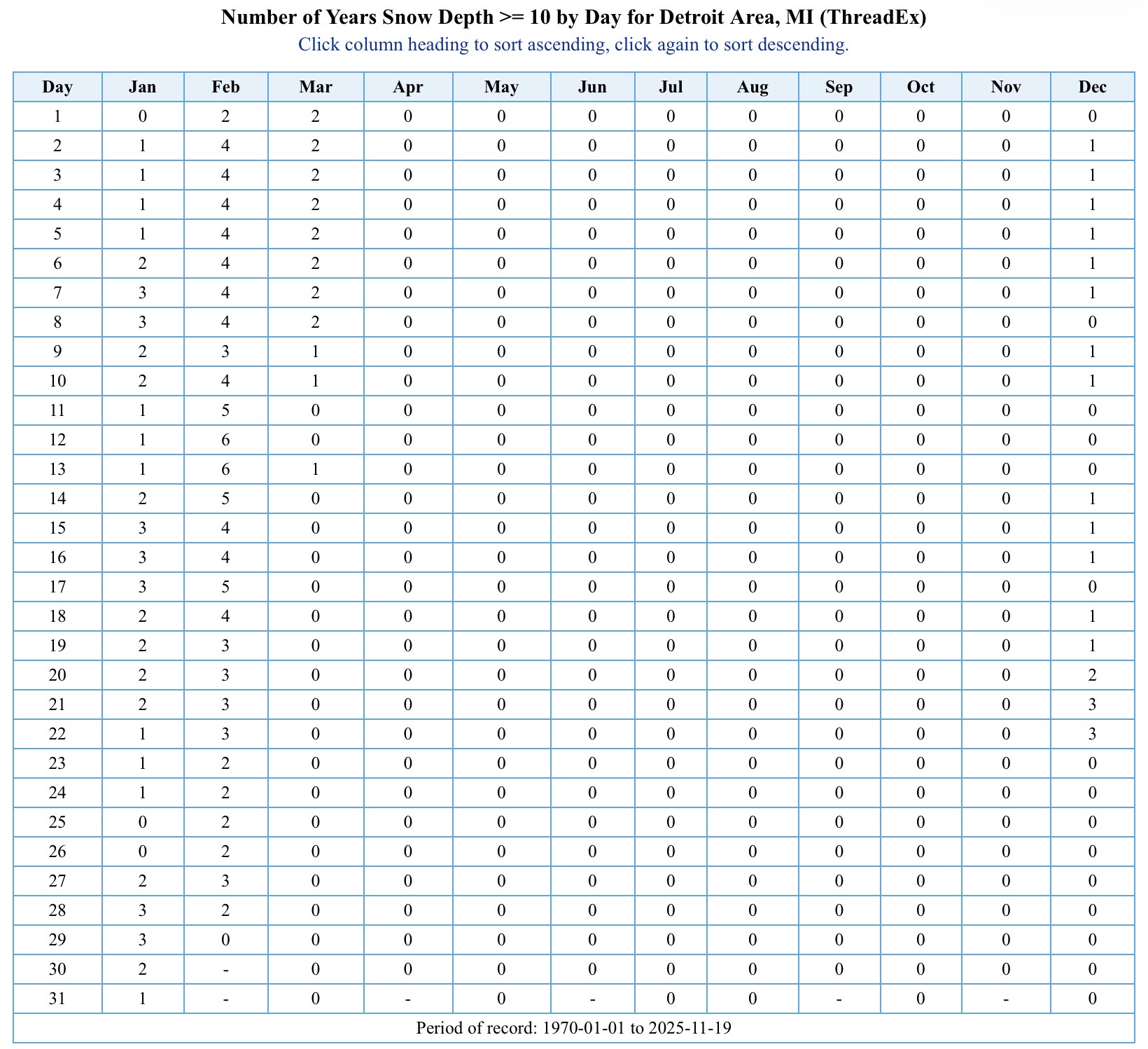
I went back to 1970 and calculated the amount of years Detroit had a 10”+ pack on each calendar day. They don’t frequently see a 10”+ pack, but it did warm my heart to see a spike the week before Christmas.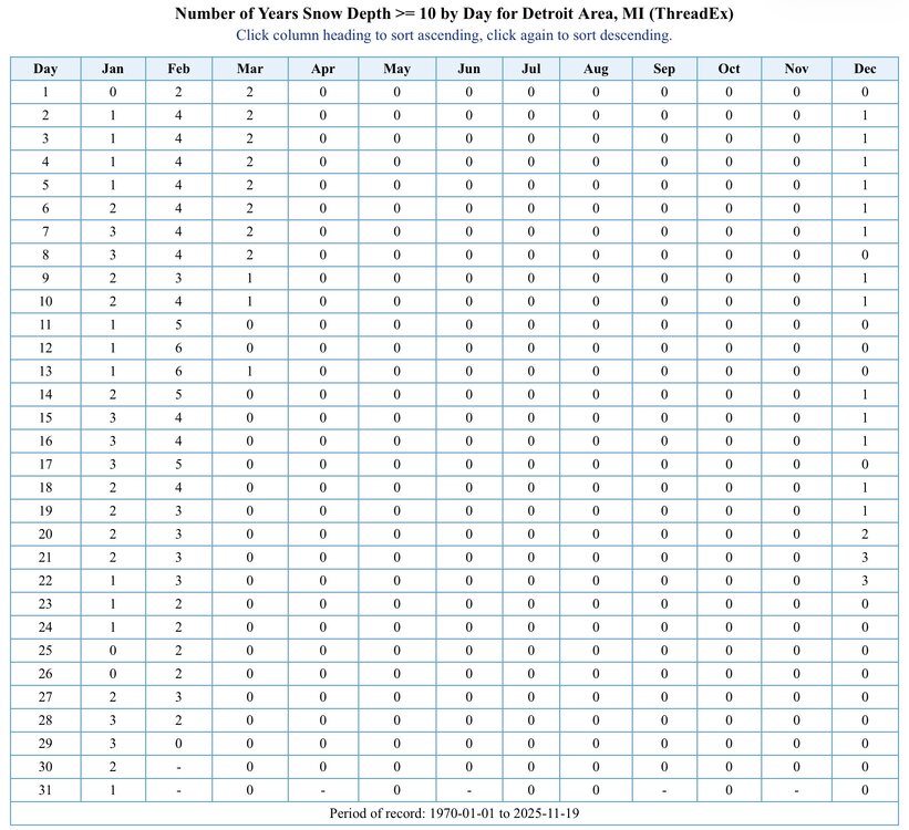
-
November 2025 general discussions and probable topic derailings ...
dendrite replied to Typhoon Tip's topic in New England
Game off?
-
November 2025 general discussions and probable topic derailings ...
dendrite replied to Typhoon Tip's topic in New England
No one has made a thread yet?
-
November 2025 general discussions and probable topic derailings ...
dendrite replied to Typhoon Tip's topic in New England
Min 21.7° 19° down in town along the river. -
November 2025 general discussions and probable topic derailings ...
dendrite replied to Typhoon Tip's topic in New England
Probably still related to Cloudflare -
November 2025 general discussions and probable topic derailings ...
dendrite replied to Typhoon Tip's topic in New England
Anyway…we’ll see. We all know these get a little overhyped before they start propagating down to the lower strat. As always, give me a decent pack before the arctic hounds arrive Looks like another chilly one tonight. Should be a lot of low 20s in CNE. -
November 2025 general discussions and probable topic derailings ...
dendrite replied to Typhoon Tip's topic in New England
Scoot: “Judah…I am your daddy” -
November 2025 general discussions and probable topic derailings ...
dendrite replied to Typhoon Tip's topic in New England
What will we get first? Epstein files GTA6 Consequential SSW -
November 2025 general discussions and probable topic derailings ...
dendrite replied to Typhoon Tip's topic in New England
Return of the Judi
-
November 2025 general discussions and probable topic derailings ...
dendrite replied to Typhoon Tip's topic in New England
I’m scared https://www.cnn.com/2025/11/19/weather/polar-vortex-cold-snowy-december-stratosphere -
Youngins
-
November 2025 general discussions and probable topic derailings ...
dendrite replied to Typhoon Tip's topic in New England
Works for temps and snow -
November 2025 general discussions and probable topic derailings ...
dendrite replied to Typhoon Tip's topic in New England
Ginxy AI coming in 3, 2, 1… -
November 2025 general discussions and probable topic derailings ...
dendrite replied to Typhoon Tip's topic in New England
Or your washer fluid froze. Do you still have the warm season blue stuff in there? -
November 2025 general discussions and probable topic derailings ...
dendrite replied to Typhoon Tip's topic in New England

-
November 2025 general discussions and probable topic derailings ...
dendrite replied to Typhoon Tip's topic in New England
EPS still looks warm for Thanksgiving…cold shot comes for the weekend -
November 2025 general discussions and probable topic derailings ...
dendrite replied to Typhoon Tip's topic in New England
Is the sensor unshielded and surrounded by Christmas trees? -
November 2025 general discussions and probable topic derailings ...
dendrite replied to Typhoon Tip's topic in New England
Basically consistent winter from beginning to end. No major breaks. I’m not sure how you’d define that down there. Up here it’s a little easier to do if you base it on snow pack streaks. Like going DJFM with at least some X value of pack. We have the ability to minimize nasty cutters here like in 07-08. -
November 2025 general discussions and probable topic derailings ...
dendrite replied to Typhoon Tip's topic in New England
I’m not up to speed…where’s that? -
November 2025 general discussions and probable topic derailings ...
dendrite replied to Typhoon Tip's topic in New England
2F at Wemby’s feet, but 20F at his head. -
November 2025 general discussions and probable topic derailings ...
dendrite replied to Typhoon Tip's topic in New England
Red flag -
November 2025 general discussions and probable topic derailings ...
dendrite replied to Typhoon Tip's topic in New England
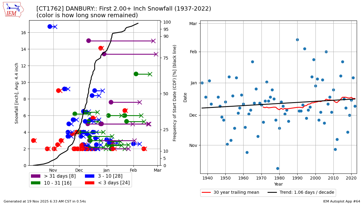
I’m not sure what the good, long-term snow COOPs are in CT, but here’s Danbury for 2”+. Maybe it’s gotten a little later, but a day per decade isn’t that big of a deal. That’s not too bad considering the background fall warming. It may look a lot different if I change it to 1” or 4” too.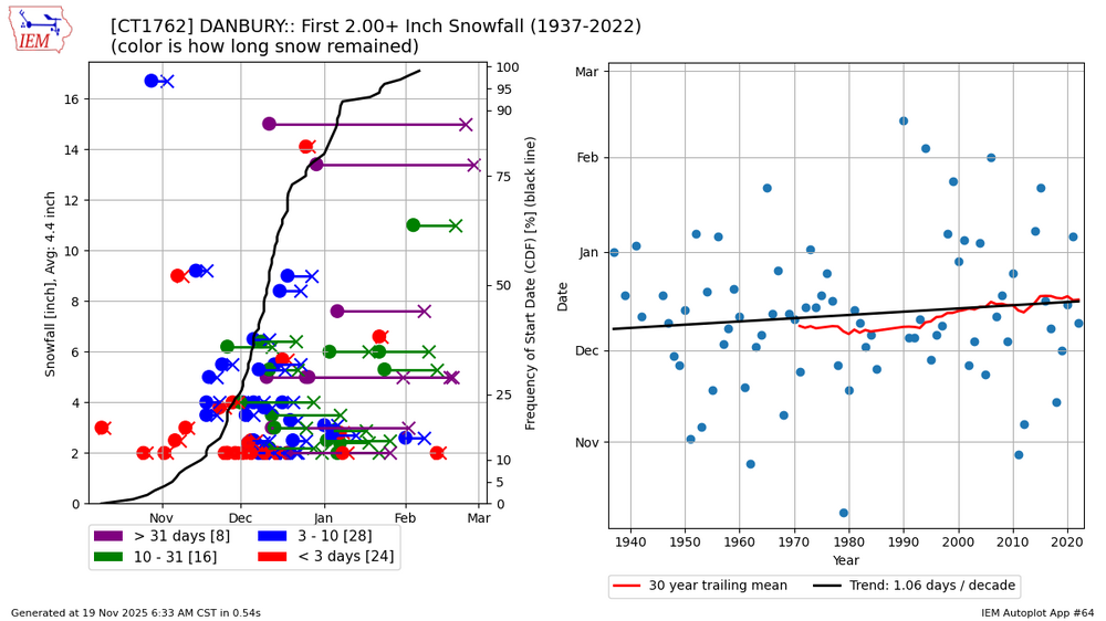
-
November 2025 general discussions and probable topic derailings ...
dendrite replied to Typhoon Tip's topic in New England
Well what do we want to define as an early snowfall? Anything measurable? 2”+? 4”+?