dendrite
-
Posts
75,095 -
Joined
Content Type
Profiles
Blogs
Forums
American Weather
Media Demo
Store
Gallery
Everything posted by dendrite
-

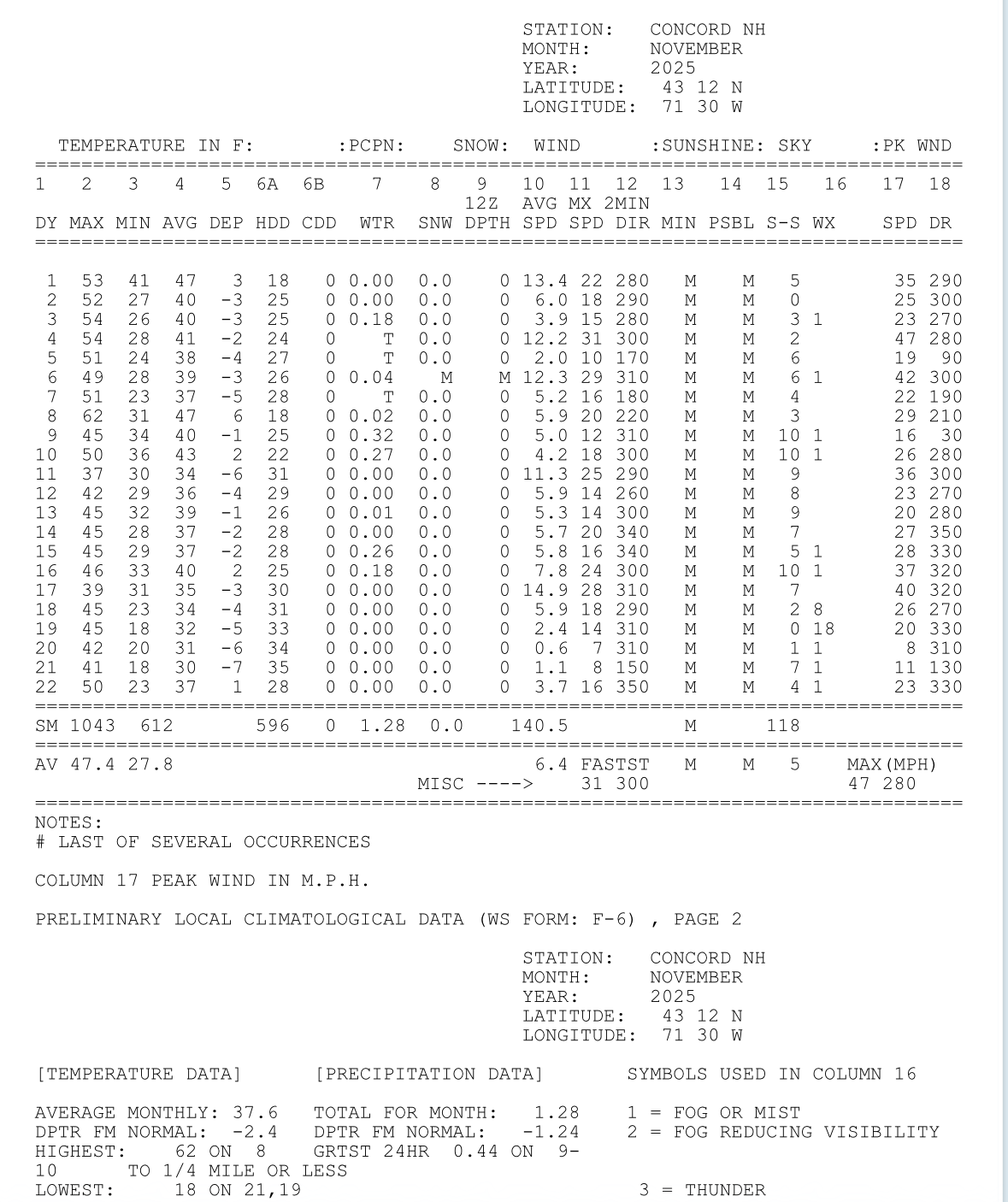
November 2025 general discussions and probable topic derailings ...
dendrite replied to Typhoon Tip's topic in New England
I was just going through my analogs and I found the dew on 12/1 is critical for the upcoming winter. If it’s 52° or over Southington averages 20” of snow. If it’s under 52° they average 70”. So this will be critical tracking. -
November 2025 general discussions and probable topic derailings ...
dendrite replied to Typhoon Tip's topic in New England
lol you’re trying to bump troll me with a d11 op run of dews that I was only trolling with to begin with. The timing may be different, but we’re in line for some warm sectors regardless. But whatev. -
November 2025 general discussions and probable topic derailings ...
dendrite replied to Typhoon Tip's topic in New England
If we got an amped up cutter it could end up 60/60. What difference does it make in the scheme of things? Either it snows or it’s some varying temp of rain over bare ground. -
November 2025 general discussions and probable topic derailings ...
dendrite replied to Typhoon Tip's topic in New England
lol. Front is through at that point, but it’s a week out. Whatever helps you sleep. A dew of 55° as we enter December isn’t the end of the world. -
November 2025 general discussions and probable topic derailings ...
dendrite replied to Typhoon Tip's topic in New England
The dews were always for a day ahead of a couple of cutters.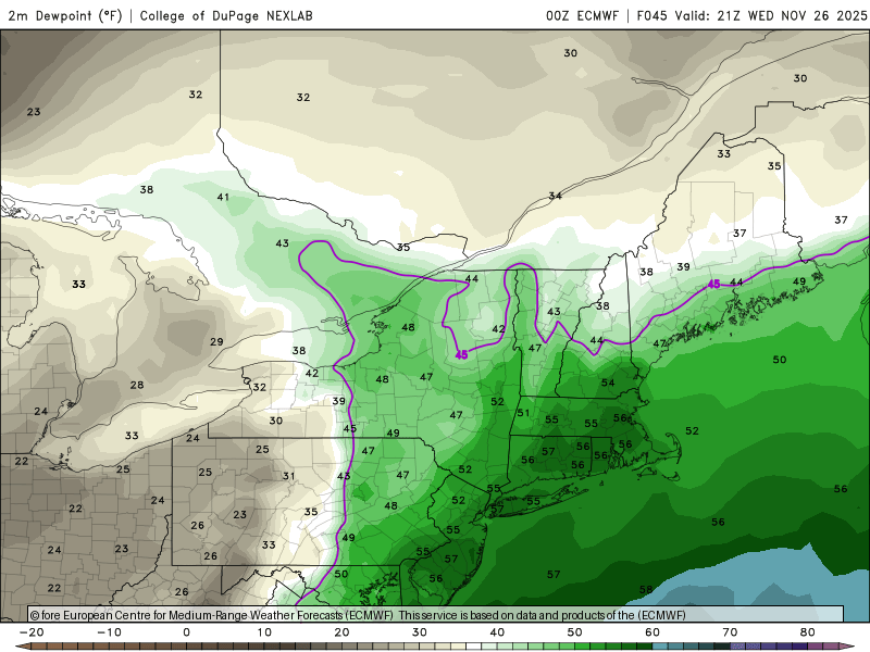
-
November 2025 general discussions and probable topic derailings ...
dendrite replied to Typhoon Tip's topic in New England
Didn’t expect it to. But it’s a couple days later now.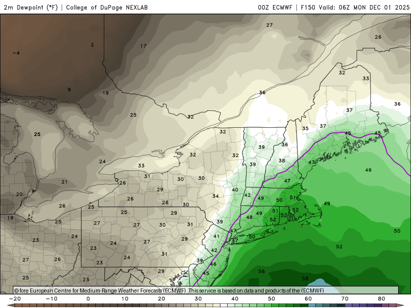
-
November 2025 general discussions and probable topic derailings ...
dendrite replied to Typhoon Tip's topic in New England
Dec 5. Just like the good ole days. -
November 2025 general discussions and probable topic derailings ...
dendrite replied to Typhoon Tip's topic in New England

-
November 2025 general discussions and probable topic derailings ...
dendrite replied to Typhoon Tip's topic in New England
Sorry but you get a for worrying about a torched SE lawn in SLK. -
November 2025 general discussions and probable topic derailings ...
dendrite replied to Typhoon Tip's topic in New England
Currently 32.3° with some snow melting. Min was 29° shortly after midnight. -
November 2025 general discussions and probable topic derailings ...
dendrite replied to Typhoon Tip's topic in New England
32.0° -SN 0.1” IMG_6993.mov -
November 2025 general discussions and probable topic derailings ...
dendrite replied to Typhoon Tip's topic in New England
33° -SN Sticking in shaded spots -
November 2025 general discussions and probable topic derailings ...
dendrite replied to Typhoon Tip's topic in New England
36° -SHSN -
November 2025 general discussions and probable topic derailings ...
dendrite replied to Typhoon Tip's topic in New England
Looks like some good bursts in the ALB area. -
November 2025 general discussions and probable topic derailings ...
dendrite replied to Typhoon Tip's topic in New England
Maybe some periods of steady snow this afternoon north of rt2 with coatings in spots? Mitch is still 26°. -
November 2025 general discussions and probable topic derailings ...
dendrite replied to Typhoon Tip's topic in New England
Warm pocket. Actually had a couple lenticulars this morn.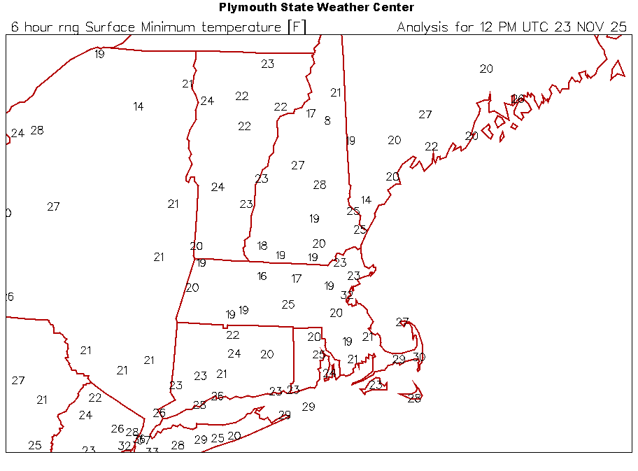
-
November 2025 general discussions and probable topic derailings ...
dendrite replied to Typhoon Tip's topic in New England
We should rename the station to that. KCO2 -
November 2025 general discussions and probable topic derailings ...
dendrite replied to Typhoon Tip's topic in New England
About as boring as you can run a -2. If we ran a +2 like this people would be saying it was faux warmth. But yeah, it’s been fairly seasonal with no real ups and downs.
-
November 2025 general discussions and probable topic derailings ...
dendrite replied to Typhoon Tip's topic in New England
Latest 17F or colder at CON is 12/12/1998. That’s pretty far out there still. -
November 2025 general discussions and probable topic derailings ...
dendrite replied to Typhoon Tip's topic in New England
Yeah…run of the mill stuff for Novie standards. -
November 2025 general discussions and probable topic derailings ...
dendrite replied to Typhoon Tip's topic in New England
Min 25.6° Lots of mid level clouds. -
November 2025 general discussions and probable topic derailings ...
dendrite replied to Typhoon Tip's topic in New England
That was a wild month. 12/20 was the big norlun…14” here -
November 2025 general discussions and probable topic derailings ...
dendrite replied to Typhoon Tip's topic in New England
You seem really optimistic and looking forward to winter this year. I wonder how long it’ll take to break you this season. -
November 2025 general discussions and probable topic derailings ...
dendrite replied to Typhoon Tip's topic in New England
Yeah let’s get a few SWFEs. Nice, low stress tracking with the wealth spread around. ineedsnow humping kuchie maps when we know it’ll be 10:1. -
November 2025 general discussions and probable topic derailings ...
dendrite replied to Typhoon Tip's topic in New England
Cold wetbulbs right off the deck.