dendrite
-
Posts
66,754 -
Joined
Content Type
Profiles
Blogs
Forums
American Weather
Media Demo
Store
Gallery
Everything posted by dendrite
-
No way. It’s the other way around for the majority of sites.
-
Hopefully everyone is staying safe tonight. Today was climatologically the lowest normal daily max temp for CON annually. It’s all up from here until July. Currently 11° with flurries.
-
That’s a nice cherry picked 354hr image. That map will change anyway after Phil doesn’t see his shadow.
-
12° with flurries Torch
-
4° and breezy. Let’s get that warmup in here.
-
Still no ice-in on Winni https://www.wmur.com/article/lake-winnipesaukee-not-fully-frozen-ice-in/46455533
-
Wtf? Did you reply to him and get your comment deleted?

-
I think the real transition day is Monday. The rad pits will probably be 0° or below Monday morning while the hills are mixed and around +10°. Then we warm up well into the 30s.
-
Thankfully this system went south. I’ve had too much snow lately…need a break.
-
7.8°
-
Meh. It’s not epic looking, but there will probably be enough cold around for some events up here. It becomes a lot more dire the further south you go. Allan is definitely more Carolina centric.
-
GWDLT
-
Eh. Never looked that warm here. A lot of NW flow and 30s to 40ish and maybe we knife in a BD colder shot here and there. Probably some snow with the WAA next week but looks like advisory or less right now. I’m just hoping to avoid any big cold. This weekend is cold enough for me.
-
6.9° Sneaky cold last night. CON hit at least 0°. Plymouth -4°.
-
9.4° First singles of the season.
-
Mar 01 was my first great snow steal on the forums. There were some great melts on WWBB.
-

At least it's something - Jan 16th Snow/Sleet/Ice OBS Thread
dendrite replied to The 4 Seasons's topic in New England
3.9”/0.31” final -
3.5”
-
At least it's something - Jan 16th Snow/Sleet/Ice OBS Thread
dendrite replied to The 4 Seasons's topic in New England
Yup. The ride home was a bear for me around 230. -
At least it's something - Jan 16th Snow/Sleet/Ice OBS Thread
dendrite replied to The 4 Seasons's topic in New England
About 3” at home. Picking back up again. 21° -
At least it's something - Jan 16th Snow/Sleet/Ice OBS Thread
dendrite replied to The 4 Seasons's topic in New England
Pushing 3.5” in CON -
At least it's something - Jan 16th Snow/Sleet/Ice OBS Thread
dendrite replied to The 4 Seasons's topic in New England
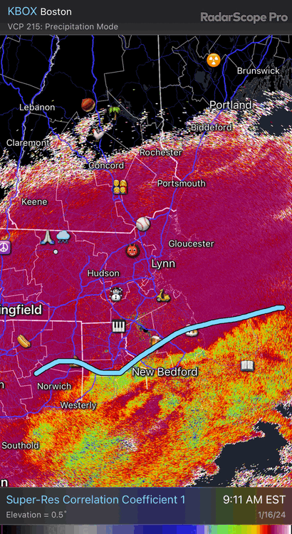
I’m in CON and it’s pounding with huge growth -
At least it's something - Jan 16th Snow/Sleet/Ice OBS Thread
dendrite replied to The 4 Seasons's topic in New England
Kinda stuck between forcing right now. Midlevel goodies back toward PF and the isentropic lift to our SE. If you loop ENX you can see the midlevel lift sliding east so we should pick up again later. -
At least it's something - Jan 16th Snow/Sleet/Ice OBS Thread
dendrite replied to The 4 Seasons's topic in New England
Current mix line